

Ha Giang Loop Budget Backpacker Guide: Doing It on $25/Day or Less
Facebook X Reddit Table of Contents Learn more: Ha Giang Loop Tours Here is the good news, and I am going to

Thúy Kiều( Grace) is a travel blogger and content contributor for Loop Trails Tours Ha Giang. She holds a bachelor’s degree in Sustainable Tourism from Vietnam National University, Hanoi, and has a strong passion for exploring and promoting responsible travel experiences in Vietnam’s northern highlands.
There are mountain roads, and then there’s Ma Pi Leng Pass. This 20-kilometer stretch of asphalt carved into the side of sheer limestone cliffs is the kind of place that makes you stop every few hundred meters just to take in what you’re seeing. The road hugs cliff faces at over 2,000 meters elevation, with drops of hundreds of meters straight down to the turquoise Nho Que River far below.
I’m not exaggerating when I say this is one of the most spectacular roads in the world. It’s consistently ranked alongside routes like Bolivia’s Death Road and Norway’s Trollstigen, except Ma Pi Leng has something those don’t: you can actually ride a motorbike along it as part of a multi-day adventure through northern Vietnam’s most dramatic landscapes.
The pass connects Dong Van and Meo Vac, two remote towns in Ha Giang province, and it’s the undisputed highlight of the Ha Giang Loop. People plan their entire trip around riding this section, and for good reason.

Learn more: Ha Giang Loop Tours
Ma Pi Leng isn’t just another scenic viewpoint or pretty mountain road. It represents something more significant: human determination carved into stone, literally.
The road you ride today was built between 1959 and 1965 by ethnic minority soldiers and local people, many of whom used only hand tools. They carved the route into vertical cliff faces, sometimes suspended by ropes while drilling holes for dynamite. The work was dangerous, the conditions were harsh, and many workers died during construction.
The name “Ma Pi Leng” comes from the H’Mong language and roughly translates to “horse’s nose bridge” or “bridge of the horse’s nose,” referring to the narrow path that once crossed these mountains. Before the road existed, travel between Dong Van and Meo Vac meant days of difficult hiking through treacherous terrain.
The pass opened up the region, connecting previously isolated communities and allowing trade, education, and development to reach areas that had been cut off for generations. Today, it’s both a functioning road for local traffic and one of Vietnam’s most famous tourist attractions.
Vietnam recognizes four mountain passes as the most spectacular and challenging in the country:
Ma Pi Leng stands out even among this group. While the others are impressive for their height and switchbacks, Ma Pi Leng combines extreme elevation with cliff-edge exposure and geological drama. The road literally hangs on the side of a mountain, with the Nho Que River canyon dropping away to one side and vertical rock walls rising on the other.
The engineering is remarkable, the views are unmatched, and the riding experience is unlike anywhere else in Vietnam. That’s why it’s not just listed among the four great passes but often cited as the greatest of them all.

Learn more: Ma Pi Leng Pass
Ma Pi Leng Pass sits in the northeastern corner of Ha Giang province, near Vietnam’s border with China. It’s part of the Dong Van Karst Plateau, a UNESCO-recognized geopark known for its dramatic limestone landscapes.
The pass connects two district towns:
The pass sits at elevations ranging from about 1,500 to over 2,000 meters above sea level. The highest point offers views extending for miles in every direction, with layer upon layer of mountains fading into blue haze toward the horizon.
The Nho Que River runs hundreds of meters below the road, carving through Tu San Canyon, one of Southeast Asia’s deepest gorges. The canyon walls are nearly vertical limestone, and the river’s distinctive turquoise color comes from minerals dissolved from the surrounding rock.
Ma Pi Leng Pass isn’t a destination you visit on a day trip. It’s part of the Ha Giang Loop, a multi-day motorcycle route that circles through the province’s northern mountains.
The standard route from Ha Giang city to Ma Pi Leng Pass is:
Day 1: Ha Giang city → Quan Ba → Yen Minh (approximately 140km)
Day 2: Yen Minh → Dong Van via Lung Cu Flag Tower (approximately 120km)
Day 3: Dong Van → Ma Pi Leng Pass → Meo Vac (approximately 80km)
This means you’ll reach Ma Pi Leng on your third day of riding, having already covered two days of beautiful but less dramatic mountain roads. The anticipation builds, and when you finally hit the pass, it delivers.
Most travelers do the loop as a 3-day or 4-day trip, with Ma Pi Leng being the highlight of day three regardless of which itinerary you choose.
The pass is one-way only in terms of traffic flow during certain hours to manage congestion and safety. However, the standard Ha Giang Loop route approaches from Dong Van heading toward Meo Vac, which is actually the preferred direction for several reasons:
Dong Van to Meo Vac (recommended):
Meo Vac to Dong Van (reverse):
If you’re joining a guided tour, the direction is predetermined. If you’re self-driving and planning your own route, stick with the standard clockwise loop that approaches Ma Pi Leng from Dong Van.

Learn more: Ha Giang Loop Itinerary
Weather and season dramatically affect the Ma Pi Leng experience. The same road can look completely different depending on whether it’s shrouded in fog, bathed in sunshine, or freshly rained on.
September to November offers the best combination of clear weather and good visibility. This is peak season for the Ha Giang Loop specifically because Ma Pi Leng is most reliably spectacular during these months.
October is the single best month. The monsoon rains have ended, the air is crisp and clear, and temperatures are comfortable for riding. Visibility often extends for miles, letting you see the full scope of the landscape. The morning fog usually burns off by mid-morning, leaving blue skies and perfect photo conditions.
November stays clear but gets cooler, with temperatures dropping to 15-20°C during the day and colder at night. The trade-off is fewer tourists than October.
December to February brings cold weather and occasional fog. Temperatures can drop to 5-10°C, especially in the early morning. Fog is more common and can last later into the day, sometimes not clearing until noon. However, when the fog does clear, visibility can be extraordinary, with incredibly clear air.
The cold season has its own beauty. Frost sometimes appears on the peaks, and the landscape takes on a stark, dramatic character. Tourist numbers drop significantly, so you might have sections of the road nearly to yourself.
March to May offers moderate temperatures and blooming flowers across the valleys. This is buckwheat flower season in some areas, adding purple to the green landscape. Rain is occasional but not constant. Visibility is generally good, though not as consistently excellent as October-November.
June to August is monsoon season. Rain is frequent, clouds sit on the mountains, and visibility can be limited. Some days are completely socked in with fog, making views impossible. However, everything is intensely green, waterfalls appear on cliff faces, and when the clouds break, the landscape is stunning.
Riding conditions during rainy season are more challenging, with wet roads and reduced visibility. If you don’t mind some rain and are a confident rider, it’s still possible, but be prepared for weather to affect your experience.
Ma Pi Leng’s weather can change quickly regardless of season. Mountain weather is unpredictable, and even during dry season you might encounter:
Check weather forecasts before your trip, but understand they’re not always accurate for mountain areas. Be flexible and prepare for changing conditions.
Ma Pi Leng gets busy during peak season, especially:
During these times, the road can feel crowded with tour groups, independent riders, and local traffic all mixing together. The viewpoints get packed with people taking photos, and the skywalk often has lines.
To minimize crowds:
If you’re on a guided tour, timing is determined by your itinerary. If you’re self-driving, you have more flexibility to adjust your schedule to avoid rush periods.
")
Learn more: Ha Giang Loop 3 Days 2 Nights
The entire 20km pass is scenic, but certain spots stand out as particularly spectacular or significant.
The Ma Pi Leng Skywalk is a modern addition to the pass, built in recent years as an official viewpoint. It’s a glass-bottomed platform that extends out from the cliff face, giving you an unobstructed view straight down to the Nho Que River hundreds of meters below.
Location: About two-thirds of the way from Dong Van to Meo Vac, clearly marked with parking and signage.
Cost: Entry fee applies (pricing can change, so check current rates when visiting).
What to expect: The platform is sturdy and safe, built to modern engineering standards. You’ll put cloth booties over your shoes before walking on the glass. The platform itself isn’t large, and during busy times there can be a wait to get onto it.
The view is impressive, particularly if you’re comfortable with heights. You can see straight down to the turquoise river, across to the opposite canyon wall, and down the valley toward Meo Vac.
Is it worth it? That depends. If you’re fascinated by glass walkways and want that specific photo, yes. If you’re indifferent to constructed viewpoints and prefer natural perspectives, you might skip it and save time for riding. The road itself offers equally dramatic views without the entrance fee.
Many tours include the skywalk in their itinerary as a scheduled stop. If you’re self-driving, the choice is yours
Beyond the skywalk, there are numerous natural viewpoints where you can safely pull over:
Heaven’s Gate Viewpoint (unofficial name): Early on the pass from Dong Van, where the road first reveals the full scope of the landscape ahead. This is where it hits you that the next 20km will be extraordinary.
Cliff-edge pullouts: Multiple spots along the route where the shoulder widens slightly, allowing bikes to park. These are informal viewpoints, often with local vendors selling drinks and snacks. The views are just as good as official spots, sometimes better.
Hairpin curves: Several dramatic switchbacks where the road doubles back on itself. From these points, you can see the road you just rode and the road ahead, all clinging to the mountainside.
Pre-Meo Vac descent: As you approach Meo Vac, there’s a section where the road descends and you get a panoramic view of the valley opening up below, with Meo Vac town visible in the distance.
Safety note: When stopping at viewpoints, park well off the road and watch for traffic. The road is narrow, and trucks or buses coming around blind curves don’t have much room to maneuver.

Learn more: Ha Giang Loop Tours
The Nho Que River is the defining feature of the Ma Pi Leng Pass landscape. Its turquoise color contrasts with the grey-brown limestone cliffs and the green vegetation, creating a striking visual.
From the pass, the river looks tiny, like a ribbon winding through the canyon floor. The scale is deceiving until you realize that what looks like a small stream is actually a substantial river, and those specks are actually boats carrying people.
The best river views are from:
Later in the itinerary, you’ll have the option to take a boat ride on the Nho Que River, experiencing it from water level instead of from hundreds of meters above.
Ma Pi Leng is one of the most photographed locations in Vietnam, and for good reason. Every angle seems to offer a compelling shot.
Best photo opportunities:
The classic Ma Pi Leng shot: Road carved into cliff with river far below, layers of mountains in background. This is the iconic image. Shoot from viewpoints facing back the way you came to capture the road in the frame.
Motorcycles on the pass: Action shots of bikes riding along the cliff edge. If you’re a passenger or have a riding companion, coordinate to capture each other riding. These photos convey the adventure aspect better than landscapes alone.
Canyon depth shots: Directly down to the river, emphasizing the vertical drop. The skywalk offers this perspective, but you can also find spots along the road where you can safely photograph straight down.
Panoramic views: Wide shots capturing the full scope of the landscape. These work best with a wide-angle lens or panorama mode on your phone.
Detail shots: Close-ups of the road surface, kilometer markers, safety signs, or interesting rock formations add variety to your collection.
Photography tips:
Drone usage: Drone flights are technically restricted in border areas like Ha Giang province. Some travelers fly drones anyway, but be aware this violates regulations. If you choose to fly, understand the risks and be respectful of local rules.

Learn more: Ha Giang Loop by Motorbike
Ma Pi Leng Pass isn’t technically difficult riding if you have genuine motorcycle experience, but it demands respect and concentration.
Surface: Variable. Recent sections have been repaved and are smooth asphalt. Older sections have cracks, potholes, and rough patches. After heavy rain, small rocks and debris can wash onto the road.
Width: The road is narrow, typically one lane in each direction with minimal shoulder. When two trucks or buses meet, there’s not much clearance on either side. When they pass each other on curves near cliff edges, it gets tight.
Curves: Numerous hairpin turns, switchbacks, and blind curves. You can’t see what’s coming around the bend, so speed control and lane positioning matter. Take curves slowly, stay on your side, and be prepared for oncoming traffic.
Elevation changes: The pass climbs and descends throughout its length. Longer descents require good brake management to avoid overheating. Longer climbs might strain smaller bikes, especially when carrying luggage and a passenger.
Traffic: Mixed. Trucks hauling goods between China and interior Vietnam, tourist buses, local motorcycles, tour groups, and independent travelers all share the road. Trucks are the main concern since they’re large, sometimes overloaded, and can’t always stop or maneuver quickly.
Guardrails: Present in some sections, completely absent in others. Where there are no barriers, the edge of the road is the edge of the cliff. A mistake means a very long fall.
Speed: Slow is appropriate. This isn’t a road for speed. The goal is experiencing the landscape, not making time. Riding at 30-40km/h gives you time to react, enjoy views, and handle unexpected situations.
Focus: Save extensive photo-taking for stopped positions. Glancing at scenery while riding is fine, but don’t get so distracted you drift in your lane or miss obstacles.
Brake management: Use both front and rear brakes, especially on descents. On long downhills, use engine braking (staying in gear rather than coasting in neutral) to avoid brake fade.
Fog riding: If you encounter fog, slow down significantly. Use your lights, stay far right, and be prepared to stop. If fog is thick enough that visibility drops below 20-30 meters, consider waiting for it to clear.
Group riding: If riding in a group, maintain spacing. Don’t ride in tight formation. Give each rider room to maneuver and react independently. Agree on hand signals before starting.
Passing: Only pass when you have clear visibility ahead and plenty of room. Don’t pass on blind curves or where the road narrows. Wait for safe straightaways.
Mechanical issues: If your bike has problems, pull over as far as possible and use hazard lights or set up warning if available. Don’t try to limp along in traffic. Call your tour operator or seek local assistance.
Weather response: If rain starts, riding becomes more challenging. Wet roads reduce traction, visibility drops, and the risk increases. Slow down, increase following distance, and ride smoothly without sudden inputs.
Mental challenge of exposure: Even if you’re an experienced rider, the cliff-edge sections with no guardrails can be psychologically difficult. Some people feel vertigo or anxiety riding past sheer drops. If this affects you, slow down, focus on the road immediately ahead (not the drop), and ride within your comfort level.
Fatigue: By the time you reach Ma Pi Leng, you’ve already ridden for two days. Mental and physical fatigue accumulate. Take breaks, stay hydrated, and don’t push beyond your limits.
Tourist distractions: Other riders stopping in the road to take photos, tour groups bunching up at viewpoints, and general tourist activity can be distracting. Stay alert and expect unpredictable behavior from others.
Altitude: At over 2,000 meters, some people feel mild altitude effects: slight breathlessness, headache, or fatigue. This is usually minor but worth being aware of. Stay hydrated and take it easy if you feel off.
Overconfidence: The scenery is so spectacular that it’s easy to get caught up in the moment and ride less carefully. The road requires consistent attention. Beautiful doesn’t mean safe.
If you’re honest with yourself about your riding ability and respect the road’s challenges, Ma Pi Leng is absolutely manageable. Thousands of tourists ride it every year without incident. The key is appropriate speed, constant attention, and conservative decisions.

Learn more: Ha Giang Loop by Jeep
How you experience Ma Pi Leng Pass depends on which type of tour you choose for the Ha Giang Loop.

Learn more: Ha Giang Loop Easy Riders
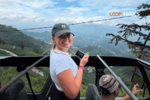
Easy rider means you ride as a passenger behind an experienced local guide who handles all the riding. This is the most popular option for Ma Pi Leng specifically because it lets you focus entirely on the experience without the stress of riding.
Advantages for Ma Pi Leng:
What it’s like: Your guide will ride at a pace that balances progress with enjoyment. They’ll point out features, stop at viewpoints, and handle all the technical riding. You’re free to look around, shoot photos (from stopped positions), and simply experience the pass.
Most easy rider guides have ridden Ma Pi Leng hundreds of times and know every curve. They’re comfortable with the road in a way that gives passengers confidence.
Cost: Easy rider tours for the full Ha Giang Loop (which includes Ma Pi Leng) typically range from 3,990,000 – 5,090,000 VND per person for a 3-4 day trip, including guide, bike, accommodation, most meals, and activities.

Learn more: Best Ha Giang Loop 2026
Self-drive means you rent a bike and ride it yourself, handling all the navigation and riding through Ma Pi Leng independently or as part of a guided group where everyone rides their own bike.
Advantages for Ma Pi Leng:
Requirements: Self-driving Ma Pi Leng requires real motorcycle experience. If you’ve only ridden scooters on flat roads, this isn’t the place to learn. The road demands skills like:
Be honest about your ability level. Ma Pi Leng is not a beginner road.
What it’s like: Riding Ma Pi Leng yourself is exhilarating but demands concentration. You’ll need to balance enjoying the scenery with watching the road, managing your speed, and handling the bike properly. The sense of accomplishment when you complete the pass is significant.
Cost: Self-drive tours for the Ha Giang Loop range from 3,390,000 – 4,190,000 VND per person for 3-4 days, including bike rental, fuel, accommodation, most meals, and activities.

Learn more: Ha Giang Cao Bang by Jeep and motorbike
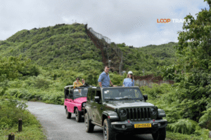
Jeep tours put you in a private vehicle with a driver who handles all the navigation and driving through Ma Pi Leng. This is the most comfortable option.
Advantages for Ma Pi Leng:
What it’s like: You’ll experience Ma Pi Leng from behind glass, which changes the feel compared to being on a motorbike. The views are just as spectacular, but you’re more removed from the environment. No wind, no engine vibration, no exposure – it’s a different type of experience.
Jeep tours can access all the same stops as motorcycle tours. You’ll visit viewpoints, the skywalk, and have opportunities to get out and photograph.
Cost: Jeep tours for the Ha Giang Loop vary by group size:
Choose easy rider if:
Choose self-drive if:
Choose jeep if:
All three options let you experience Ma Pi Leng Pass. The best choice is the one that matches your experience level, comfort, and what you want from the trip.

Learn more: How to from Ha Noi to Ha Giang
The Nho Que River and Tu San Canyon are inseparable from the Ma Pi Leng Pass experience. The pass exists because of the canyon, and the canyon’s drama is best appreciated from the pass.
Tu San Canyon was formed over millions of years by the Nho Que River cutting through limestone. The canyon walls are nearly vertical, dropping approximately 800 meters from rim to river. This makes it one of the deepest canyons in Southeast Asia.
The limestone bedrock is part of the same geological formation that creates all the karst features throughout Ha Giang: the peaks, caves, sinkholes, and dramatic topography that define the region.
The Nho Que River’s turquoise color comes from limestone minerals dissolved in the water. The intensity of the color varies depending on season, water level, and weather. After heavy rain, the river can become muddier and less vivid. During dry season, the turquoise is most pronounced.
After crossing Ma Pi Leng Pass, most Ha Giang Loop itineraries include a boat ride on the Nho Que River. This happens near Sung Trai village, where there’s a boat dock.
What to expect: Traditional wooden boats with outboard motors take small groups (usually 6-12 people) along a section of the river. The ride lasts 30-40 minutes, traveling through the canyon with vertical walls rising hundreds of meters on both sides.
The experience: From water level, the canyon’s scale becomes even more impressive. Looking up at the cliffs you viewed from above creates a completely different perspective. The water is incredibly clear, and the turquoise color is vivid up close.
The boat operator points out features along the canyon and sometimes shares stories about the area. It’s peaceful on the river, a contrast to the riding and a chance to experience the landscape from a different angle.
Cost: Boat rides are typically included in tour packages. If you’re traveling independently, tickets can be purchased at the dock. Pricing varies, so check current rates when visiting.
Timing: Most tours schedule the boat ride after crossing Ma Pi Leng and having lunch in Sung Trai or Meo Vac. It fits naturally into the day’s itinerary.
The best Tu San Canyon views are from Ma Pi Leng Pass itself. There are several viewpoints where you can see the full depth of the canyon with the river far below.
The canyon runs for many kilometers, but the deepest and most dramatic sections are visible from the pass. The geology is impressive: horizontal limestone layers stacked over millions of years, now exposed as vertical cliffs.
During the boat ride, you’re inside the canyon, so you can’t see its full scope. The view from above and the experience from within are both valuable for understanding the landscape’s scale.

Learn more: Ha Giang Loop Trails
Ma Pi Leng Pass connects two district towns that serve as bases for exploring the area.
Dong Van sits at the western end of Ma Pi Leng Pass, about 145km from Ha Giang city. It’s where most travelers spend the night before riding the pass.
What’s there: Dong Van is a small mountain town with more character than you’d expect. The old quarter has preserved traditional architecture: century-old houses with tile roofs, wooden structures, and stone walls. Walking through the old quarter in the evening is pleasant, with lanterns lighting narrow streets.
The town has basic amenities: restaurants, small shops, a Sunday market that draws ethnic minorities from surrounding villages, and accommodation ranging from simple homestays to basic hotels.
Accommodation: Most tour packages include homestay accommodation in Dong Van. These range from traditional old quarter houses to newer structures on the edges of town. Facilities are basic but adequate: beds with blankets, shared bathrooms (usually with hot water), and communal dining areas.
Sunday market: If you’re in Dong Van on Sunday, the market is worth visiting. It starts early (around 5-6am) and runs until mid-morning. Local people from H’Mong, Tay, and other ethnic minority groups come to trade livestock, vegetables, tools, and goods. It’s authentic rather than tourist-oriented, giving you a glimpse of regional commerce.
Atmosphere: Dong Van feels remote, surrounded by mountains and close to the Chinese border. At night, the town is quiet except for a few restaurants and the occasional karaoke venue. The setting is dramatic, with rocky peaks visible from most parts of town.

Learn more: Ha Giang Loop Guide
Meo Vac sits at the eastern end of Ma Pi Leng Pass, roughly 25km from the pass’s highest point. It’s smaller than Dong Van but serves as a district capital.
What’s there: Meo Vac has less tourist infrastructure than Dong Van. There are several restaurants along the main road, basic shops, and some accommodation options. Most travelers pass through Meo Vac for lunch after crossing Ma Pi Leng rather than staying overnight.
Sunday market: Like Dong Van, Meo Vac has a Sunday market that’s authentic and focused on local trade rather than tourism. Livestock, vegetables, and household goods are the main items. It starts early and finishes by mid-morning.
Love market: Meo Vac is famous for its “love market,” a cultural tradition where young H’Mong people meet potential partners. The market happens on certain dates (traditionally tied to the lunar calendar) and has become a tourist attraction. If you’re planning to visit specifically for the love market, check dates in advance and understand it’s partly traditional, partly tourist-focused now.
Accommodation: Limited compared to Dong Van. There are a few hotels and guesthouses, mostly serving local Vietnamese travelers and the occasional tourist who stays to explore further.
Most Ha Giang Loop itineraries spend night two in Dong Van (before Ma Pi Leng) and continue past Meo Vac to Du Gia or another village for night three (after Ma Pi Leng). This makes Dong Van the more relevant overnight base for experiencing the pass.

Learn more: Ha Giang Cao Bang Loop Tours
Beyond the riding and scenery, there are practical considerations that affect your Ma Pi Leng experience.
What to bring:
Clothing: Layers work best. Mornings can be cool, midday warm, and late afternoon cool again. Long sleeves provide sun protection even when temperatures rise. If you’re on a motorbike, wind chill at elevation makes it feel colder than the air temperature.
Timing your ride: Most tours hit Ma Pi Leng mid-morning to early afternoon, which is ideal. Morning fog usually clears by 9-10am, giving you clear views. Starting the pass around 10am-12pm puts you in the best light and weather window.
Bathroom facilities: Limited. There are basic facilities at the skywalk and occasionally at viewpoints with vendors. Otherwise, plan accordingly.
Food and drink: Vendors at major viewpoints sell water, soft drinks, beer, instant noodles, and snacks. Prices are higher than in towns (as expected at remote locations), but not unreasonable. Support local vendors by buying something if you stop at their viewpoint.
Phone signal: Intermittent. Some sections have signal, others don’t. Don’t rely on constant connectivity. Download offline maps before the trip.
Safety: The road is safe if you ride appropriately. Accidents happen when people ride too fast, get distracted, or attempt maneuvers beyond their skill level. Ride conservatively and you’ll be fine.
Respect for locals: This is a functioning road that local people use daily for work and transport. Be courteous, don’t block traffic unnecessarily, and be mindful that your tourist adventure is their commute or work route.
Environmental responsibility: Take your trash with you. Don’t leave water bottles, food wrappers, or anything else at viewpoints. The landscape is spectacular partly because it’s been preserved; help keep it that way.
Border area sensitivity: Ma Pi Leng is close to the Chinese border. Photography of military installations, if you see any, is not appropriate. Stick to landscape and cultural photos.
Group dynamics: If you’re on a tour, be punctual at stops. Guides have schedules to maintain, and making the group wait affects everyone. Be considerate of your fellow travelers.
The pass itself is about 20km long. Pure riding time is roughly 45 minutes to an hour, but with stops for viewpoints, photos, and possibly the skywalk, expect to spend 2-3 hours on this section. Most tours build in plenty of time because it’s the highlight of the trip and rushing through defeats the purpose.
Not safely on their own. The road requires genuine motorcycle experience: comfort with geared bikes, mountain riding skills, and the ability to handle cliff-edge exposure. If you’re a beginner or have limited experience, take an easy rider tour where you ride as a passenger, or choose a jeep tour. Attempting to self-drive without adequate skill is dangerous for you and others on the road.
It has inherent risks: cliff edges without guardrails, narrow roads, mixed traffic, and challenging conditions. However, thousands of people ride it safely every year. The danger comes from riding beyond your ability, going too fast, or not paying attention. Ride appropriately and respect the road, and it’s manageable. Easy rider and jeep options significantly reduce risk.
Mid-morning to early afternoon (10am-2pm) is ideal. Morning fog has usually cleared by 10am, giving you clear views and good light for photos. Late afternoon light can be beautiful but temperatures drop and shadows lengthen. Avoid riding the pass at dawn (fog risk) or dusk (visibility issues and cooling temperatures).
No special permits are required for tourists to visit Ma Pi Leng Pass. It’s part of the public road system. However, Ha Giang province does require foreign visitors to register their presence in certain districts. Tour operators handle this registration as part of their service. If you’re traveling independently, check current regulations about registration requirements.
Not practically. The pass is 145km from Ha Giang city with a full day of mountain riding in between. A day trip would mean leaving Ha Giang at dawn, rushing through all the scenery, crossing the pass, and immediately returning – a brutal 10+ hour riding day that defeats the purpose. The pass is best experienced as part of the multi-day Ha Giang Loop where you stay overnight in Dong Van before crossing.
If fog, rain, or other weather makes conditions dangerous, good tour operators will delay the ride until conditions improve or, in extreme cases, modify the route. Safety takes priority over schedule. If you’re self-driving, use your judgment – it’s better to wait a few hours for fog to clear than to ride blind. The flexibility of multi-day itineraries usually allows for weather delays without ruining the trip.
There’s no toll to use the road itself. The only cost is if you choose to visit the Ma Pi Leng Skywalk, which has an entrance fee. Exact pricing can change, so check current rates when visiting. If you’re on a tour package, the skywalk fee is usually included. Other viewpoints along the pass are free.
In a jeep tour, yes. Children can safely experience the pass from inside a vehicle. On motorbikes, it’s more complicated. Older children who can sit still behind a rider and hold on properly might be okay on an easy rider tour, but young children are not appropriate for motorbike touring on this road. Assess your child’s ability to safely ride as a passenger before booking.
Technically, Ha Giang province has restrictions on drone flights due to its proximity to the Chinese border and security sensitivities. Some travelers fly drones anyway, but this violates regulations. If you choose to fly despite restrictions, understand the legal risk and potential confiscation of equipment. Be respectful of local rules regarding border security.
Wet roads reduce traction and visibility. Puddles can hide potholes, and water running across the road creates slippery patches. Rocks and debris sometimes wash onto the pavement. Riding after rain requires slower speeds, gentler braking, and more careful line choice through corners. If it’s currently raining hard, waiting for it to stop is wise. Light rain that’s clearing is manageable with caution.
Minimal. Dong Van and Meo Vac have basic health clinics that can handle minor injuries or illnesses, but serious medical issues require evacuation to Ha Giang city or Hanoi. Travel insurance that covers emergency medical evacuation is essential. Tour operators should have emergency plans for serious accidents, but medical care in this remote region is limited.
Contact information for Loop Trails
Website: Loop Trails Official Website
Email: looptrailshostel@gmail.com
Hotline & WhatSapp:
+84862379288
+84938988593
Social Media:
Facebook: Loop Trails Tours Ha Giang
Instagram: Loop Trails Tours Ha Giang
TikTok: Loop Trails
Office Address: 48 Nguyen Du, Ha Giang 1, Tuyen Quang
Address: 48 Nguyen Du, Ha Giang 1, Tuyen Quang
Facebook X Reddit Table of Contents Learn more: Ha Giang Loop Tours Here is the good news, and I am going to
Facebook X Reddit Table of Contents Learn more: Ha Giang Loop Tours Most people come to Ha Giang for the adrenaline. The
Facebook X Reddit Table of Contents Learn more: Ha Giang Loop Tours Every few weeks someone messages us with a version of