
Best Time to Visit Ha Giang- Cao Bang Loop: Complete Guide
Facebook X Reddit Table of Contents Learn more: Ha Giang Motorbike Rental Deciding when to tackle the Ha Giang–Cao Bang combo

Thúy Kiều is a travel blogger and content contributor for Loop Trails Tours Ha Giang. She holds a bachelor’s degree in Sustainable Tourism from Vietnam National University, Hanoi, and has a strong passion for exploring and promoting responsible travel experiences in Vietnam’s northern highlands.
When people first hear about Ha Giang, the reaction is usually the same: “Where exactly is that?” It’s not surprising. Ha Giang doesn’t appear on most Vietnam tourist trail maps the way Hanoi, Halong Bay, or Hoi An do. That remoteness is precisely what makes it extraordinary.
Ha Giang sits at the absolute northern edge of Vietnam, pressed against the Chinese border, surrounded by some of the most dramatic mountain terrain in Southeast Asia. Getting there requires commitment—it’s not a quick day trip from Hanoi. But that distance from the well-trodden path is what has preserved the authentic mountain culture, the jaw-dropping scenery, and the kind of adventure that feels increasingly rare in modern travel.
I’ve guided people through Ha Giang countless times, and the location itself tells a story. You’re riding roads that zigzag along cliff edges, passing through valleys where ethnic minority villages have existed for centuries, crossing passes that literally mark the edge of Vietnam. Understanding where Ha Giang is helps you appreciate why this journey feels so different from anywhere else in the country.
This guide breaks down Ha Giang’s location, shows you exactly where the famous Loop takes you, and explains the best ways to get there depending on where you’re coming from.

Learn more: Best Ha Giang Loop Tours

Learn more: Ha Giang Loop Map
Ha Giang occupies the northernmost territory of Vietnam, and when I say northernmost, I mean you literally can’t go further north without crossing into China. This isn’t just geographic trivia—it shapes everything about the region.
Ha Giang Province forms the “roof” of Vietnam, sitting at the country’s extreme northern tip. If you look at a map of Vietnam, Ha Giang is where the border with China creates a jagged, irregular line following mountain ridges and river valleys.
The province shares borders with:
This border position means Ha Giang has always been a cultural crossroads. The ethnic minorities here—H’Mong, Tay, Dao, Lo Lo—have connections and similarities with communities across the border. You’ll notice this in the architecture, clothing, and languages spoken in remote villages.
Understanding distances helps you plan logistics:
From Hanoi: Approximately 300 kilometers (186 miles) north. By bus, this translates to 6-8 hours depending on road conditions and traffic. The journey starts flat through the Red River Delta, then gradually climbs into increasingly mountainous terrain.
From Sapa: Around 270 kilometers (168 miles) east, roughly 8-9 hours by road. This route cuts across the northern mountains and isn’t as frequently traveled as the Hanoi route.
From Halong Bay: Approximately 400 kilometers (248 miles) northwest, about 8-9 hours accounting for the route around the delta and into the mountains.
From Cao Bang: About 200 kilometers (124 miles) west. This becomes relevant if you’re doing the combined Ha Giang-Cao Bang Loop.
These aren’t short distances, but the remoteness is what has kept Ha Giang relatively undiscovered compared to other Vietnamese destinations.
The Chinese border isn’t just a line on a map—it’s a physical presence in Ha Giang. When you’re riding through Dong Van district or standing at Lung Cu Flag Tower (Vietnam’s northernmost point), you can literally see Chinese territory across the valley.
This proximity has historical significance. The region has seen conflicts, trade, cultural exchange, and migration over centuries. During the Vietnam War, Ha Giang’s strategic position made it significant for border defense. Today, that same position makes it a place where Vietnamese national identity feels particularly strong—you’ll see Vietnamese flags prominently displayed, especially near border areas.
The border also creates some travel restrictions. Certain areas very close to the border require permits for foreigners (though standard Loop routes don’t enter these zones). Your tour operator or rental company will know which areas are accessible.

Learn more: Ha Giang Loop 2 Days 1 Night
This distinction confuses many first-timers, so let’s clarify it before diving deeper.
Ha Giang City is the provincial capital and your starting point for the Loop. It’s a small city by Vietnamese standards—you can walk across the downtown area in 20 minutes. The population is around 60,000, and the vibe is more “large town” than bustling metropolis.
This is where you’ll:
Ha Giang City sits in a valley at a relatively low elevation (about 200 meters above sea level). It’s not particularly scenic compared to what you’ll see on the Loop, but it has the infrastructure you need: hotels, restaurants, mechanics, shops, and the starting point for the QL4C highway that begins the Loop route.
Ha Giang Province is massive—over 7,900 square kilometers of primarily mountainous terrain. The province contains numerous districts, each with its own character:
Quan Ba District: Your first stop after leaving Ha Giang City. Known for Heaven’s Gate viewpoint and the distinctive “Fairy Bosom” twin mountains.
Yen Minh District: A transition zone between the lower valleys and the high plateau. This is where terrain becomes increasingly dramatic.
Dong Van District: The heart of the Dong Van Karst Plateau Geopark (a UNESCO Global Geopark). This is where you’ll find the famous Old Quarter of Dong Van town, the H’Mong King’s Palace, and roads that wind through otherworldly karst formations.
Meo Vac District: Home to Ma Pi Leng Pass, often called one of the four greatest mountain passes in Vietnam. The Nho Que River carves through impossibly deep canyons here.
When people say they’re “doing the Ha Giang Loop,” they’re traveling through multiple districts of Ha Giang Province, starting and ending in Ha Giang City.
The standard 3-4 day Loop takes you through these main stops:
Each location has its own character, elevation, and significance along the route.

Learn more: Starting Your Loop Adventure
Understanding the geography before you go makes the experience richer. You’re not just riding randomly through mountains—you’re following a logical route that showcases different aspects of the region.
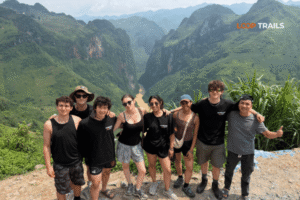
“The Loop” refers to a roughly circular route that starts and ends in Ha Giang City, traveling north and east through the most spectacular scenery before looping back. The standard route is approximately 350-400 kilometers depending on exact stops and detours.
Think of it as a clockwise circle:
The beauty of this route is that it’s naturally scenic—you’re not hunting for photo spots. The entire road is the attraction.
Here’s what makes each major location significant:
Heaven’s Gate (Quan Ba): Your first real “wow” moment, about 50 kilometers from Ha Giang City. The road climbs to this pass where you get panoramic views of the Quan Ba valley with its distinctive twin limestone peaks.
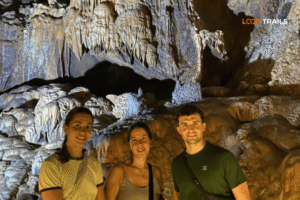
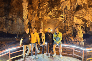
Lung Khuy Cave (Quan Ba): A short trek off the main road leads to this impressive cave system. Not everyone stops here, but it’s worth the detour if you have time.
Tham Ma Pass: One of several challenging mountain passes, this one has particularly tight switchbacks and steep gradients.
Vuong Palace (Dong Van): The former residence of the H’Mong King, this unique building shows Chinese-Vietnamese architectural fusion and tells the story of the region’s complex history.
Lung Cu Flag Tower: The northernmost accessible point in Vietnam, marked by a giant flag tower. On clear days, Chinese villages are visible across the valley.
Lo Lo Chai Village: One of the few remaining villages of the Lo Lo ethnic minority, known for their distinctive rammed-earth houses.
Ma Pi Leng Pass: The crown jewel of the Loop. This pass was hand-carved by local volunteers in the 1960s, and the road hugs cliff faces hundreds of meters above the Nho Que River. Many consider this the most spectacular mountain pass in Vietnam.
Nho Que River: The turquoise river that winds through Tu San Canyon, one of Southeast Asia’s deepest canyons. Boat tours let you experience the canyon from water level.
Du Gia Village: A peaceful village surrounded by rice terraces, with a beautiful waterfall for swimming. This is often the third night’s stop on 4-day tours.
Lung Tam Village: Known for traditional hemp and linen weaving. You can watch H’Mong women demonstrate ancient textile techniques.
The standard Loop described above is what most people do, but variations exist:
2-Day Express Loop: Covers the highlights quickly, usually going Dong Van on Day 1, then Ma Pi Leng and back on Day 2. This is rushed but possible if you’re time-constrained.
3-Day Standard Loop: The most popular option. Day 1 to Dong Van, Day 2 through Ma Pi Leng to Du Gia or Meo Vac, Day 3 back to Ha Giang.
4-Day Comprehensive Loop: Adds more stops and a more relaxed pace, often including trekking, cave visits, and more time in villages.
5-Day Ha Giang + Cao Bang: Extends east from Meo Vac into Cao Bang Province to visit Ban Gioc Waterfall and other Cao Bang highlights before returning.

Learn more: Ma Pi Leng Pass
Geography isn’t just coordinates on a map—it shapes culture, preserves traditions, and creates the conditions for extraordinary natural beauty.
Ha Giang’s location at the intersection of multiple geological zones creates incredible landscape variety. Within a few hours of riding, you’ll transition through:
Limestone Karst Terrain: The Dong Van Plateau features “tower karst” formations—vertical limestone pillars rising from valleys. This creates the otherworldly scenery that makes photos from Ha Giang so distinctive.
River Valleys: Deep valleys carved by rivers over millions of years create dramatic elevation changes. The Nho Que River canyon exemplifies this—vertical drops of 700+ meters from road level to river.
Rice Terraces: In areas with gentler slopes and more water, ethnic minorities have carved terraced rice fields into the mountainsides, creating patterns that change with seasons.
High Passes: Multiple passes exceed 1,500 meters elevation, creating cool microclimates and panoramic viewpoints.
This diversity means the Loop never feels monotonous. Every section offers something visually different.
Ha Giang’s position as frontier territory has shaped its cultural identity. The remoteness that once made governance difficult has allowed ethnic minority groups to maintain traditional lifestyles longer than in more accessible regions.
The H’Mong, Tay, Dao, and Lo Lo communities here have kept:
When you stay in homestays along the Loop, you’re not experiencing a tourism facade—these are real homes where people live according to patterns established long before tourists arrived.
Here’s the sweet spot Ha Giang occupies: it’s remote enough to have preserved authentic culture and pristine scenery, yet accessible enough that travelers can experience it without extreme expedition-level preparation.
You don’t need:
You do need:
This balance is rare. Many of the world’s most spectacular mountain regions require serious mountaineering skills or massive budgets. Ha Giang gives you 80% of the beauty and cultural authenticity with 20% of the difficulty.

Lean more: Ha Giang Sleeper Bus from Hanoi
Hanoi is the primary gateway to Ha Giang for international travelers. Most people fly into Hanoi, spend a day or two in the city, then head north to Ha Giang.
Buses are the standard choice for budget and mid-range travelers. The route is well-established with multiple daily departures.
Night Sleeper Buses: Depart Hanoi between 8 PM – 11 PM, arriving Ha Giang 4 AM – 7 AM. This saves you a night’s accommodation and arrives early enough to rest before tour briefings (usually 8-9 AM).
Prices range from 200,000 – 600,000 VND depending on bus quality:
Day Buses: Less common but available if you prefer seeing the landscape. Depart early morning, arrive mid-afternoon. You’ll need accommodation in Ha Giang City that night before starting your Loop.
Most Ha Giang Loop tour operators can arrange bus tickets as part of your package, which simplifies coordination and ensures pickup times align with your tour start.
Private cars make sense for groups of 3-4+ people when the per-person cost approaches bus prices but offers significantly more comfort and flexibility.
Prices for private transfer:
Benefits beyond comfort:
For families or groups who value comfort, this is worth considering.
Some experienced riders choose to motorbike the 300 kilometers from Hanoi to Ha Giang as part of their adventure. This takes 8-12 hours of riding depending on your pace and stops.
Only attempt this if you’re:
For most people, especially first-time Vietnam visitors, taking a bus or car to Ha Giang and starting your motorbike adventure there makes more sense. You’ll have 350+ kilometers of incredible riding ahead on the Loop—no need to add highway kilometers before you even arrive.

Learn more: Ha Giang vs Sapa 2026
Not everyone follows the standard Hanoi → Ha Giang route. If you’re building a northern Vietnam itinerary, these alternatives might fit better.
Sapa to Ha Giang direct buses save backtracking to Hanoi. The journey takes 8-10 hours through mountain roads, usually on night buses departing Sapa in the evening.
This works well if you’re doing: Hanoi → Sapa (trekking) → Ha Giang (Loop) → back to Hanoi or onward. You skip the inefficient Sapa → Hanoi → Ha Giang triangle.
Prices: 300,000 – 450,000 VND per person. Book through your Sapa hotel or online platforms.
Halong Bay or Cat Ba to Ha Giang requires planning as direct buses aren’t daily. Your options:
Most practical approach: If you’re doing Halong first, book a Ha Giang Loop tour package that includes bus coordination from Halong Bay. Tour operators handle the logistics.
Ninh Binh to Ha Giang direct buses are emerging as people realize they can skip returning to Hanoi. Departures are usually evening buses, arriving Ha Giang early morning.
Journey time: 7-8 hours Prices: 250,000 – 400,000 VND
This creates a nice flow: Hanoi → Ninh Binh (karst landscapes and temples) → Ha Giang (mountain karst and culture) → back to Hanoi.

Learn more: Ha Giang in September & October
Ha Giang’s location at high elevation and far north creates weather patterns different from Hanoi or southern Vietnam. Timing your visit matters.
September to November (Peak Season): The most popular months for good reason. After the summer rains, the rice terraces are bright green or golden (depending on specific timing), roads are in best condition, and temperatures are comfortable for riding—cool mornings around 15-18°C, pleasant afternoons 22-25°C.
The downside: More tourists, higher prices, and you’ll need to book tours and buses in advance.
March to May (Second Best): Spring in Ha Giang brings blooming flowers, clear skies, and comfortable temperatures. Fewer tourists than autumn, but still excellent riding conditions. This is when you’ll see peach blossoms, canola flowers, and other spring blooms coloring the landscape.
December to February (Cold Season): Ha Giang’s northern location means real winter. Temperatures can drop to 5-10°C, occasionally near freezing at high elevations. Some passes may have fog or ice in early morning. You’ll need proper warm gear, but the upside is very few tourists and a different, moody atmosphere.
June to August (Rainy Season): Summer brings rain—sometimes heavy, sustained downpours. Roads can be slippery or damaged, landslides are possible, and clouds obscure mountain views. However, this is also when rice is green and lush. Some experienced travelers prefer this season for the dramatic clouds and empty roads, but it’s riskier for first-timers.
Ha Giang’s elevation creates microclimates. You might start the day warm in Quan Ba, encounter fog and cold at Ma Pi Leng Pass (1,500+ meters elevation), then warm up again descending to Meo Vac.
Pack layers regardless of season. Morning temperatures at high passes are always 5-10°C cooler than valley floors.
Rain can be sudden and intense, even outside rainy season. Afternoon storms are common. Good rain gear isn’t optional—it’s essential.
The Khau Vai Love Market (usually late March/early April) is a unique cultural event where ethnic minorities gather for a traditional festival. If timing works, it’s fascinating, but expect more tourists.
Lunar New Year (Tet) in late January or February sees Vietnamese tourists, but ethnic minority communities celebrate differently with their own traditions.

Learn more: What to Expect When You Arrive in Ha Giang
Your first impressions of Ha Giang City set the stage for what’s coming.
Ha Giang City feels like a frontier town, which it essentially is. The architecture is mostly concrete block buildings from the 1980s-2000s, not traditionally charming. The downtown area clusters around a small lake and has the essential services you need.
This isn’t a beautiful city—it’s a functional base camp. Don’t expect Hanoi’s Old Quarter or Hoi An’s atmosphere. What you will find:
The real action happens at hostels that cater to Loop travelers. This is where you’ll meet other people doing the Loop, get briefed on routes, rent bikes or meet your tour group, and handle final preparations.
Ha Giang City has:
ATMs: Multiple ATMs in town center. Withdraw cash here because ATMs are rare once you’re on the Loop. Some homestays accept bank transfer, but cash is safer.
Pharmacies: Basic medications available. Bring prescription medications from Hanoi.
Mechanics: If you’re self-driving and have mechanical issues, Ha Giang City is the last place with proper bike shops until you return. Most rental companies will fix minor issues for free.
Petrol stations: Several in town. Fill up before leaving—petrol is available along the Loop but stations are spaced out.
Markets: The central market is worth visiting early morning to see local produce and ethnic minority vendors.
Phone signal: Good in town center. Buy SIM cards in Hanoi if you need data—options are limited here.
Most tours start with a morning briefing covering:
If you’re self-driving, rental companies will:
The first day’s ride to Dong Van is about 150 kilometers, taking 6-8 hours with stops. This eases you into mountain riding before the more challenging Ma Pi Leng section on Day 2.

Learn more: Day-by-Day Route Overview
Understanding the day-by-day flow helps you mentally prepare for what each section demands.
Day 1: Ha Giang City → Dong Van You’ll cover approximately 150km climbing from Ha Giang City’s low elevation through multiple passes. Key highlights:
This day establishes the pattern: long riding with frequent stops for scenery and culture. The roads are good but winding.
Day 2: Dong Van → Meo Vac/Du Gia The flagship day featuring Ma Pi Leng Pass. Approximately 100-120km but more intense:
This is the day everyone remembers. Ma Pi Leng is genuinely spectacular, but also the most dangerous section—steep drops, narrow roads, frequent traffic including trucks.
Day 3: Du Gia → Ha Giang City (3-day tour endpoint) The return journey, approximately 120-140km:
The riding is easier as you’re retracing some routes and mostly descending, but fatigue is real by Day 3.
Day 4 (if doing 4-day tour): Adds more village visits, additional trekking, or extends further east toward Cao Bang before looping back.
Beyond the major stops, smaller moments make the Loop memorable:
Roadside encounters: Old H’Mong women selling fresh corn or honey, kids waving from schoolyards, farmers with water buffalo crossing the road.
Local markets: If your timing aligns, weekend markets in places like Dong Van or Meo Vac show authentic trading culture.
Homestay meals: Evening dinners with host families often include local specialties and rice wine (happy water).
Sunset spots: Dong Van Old Quarter at dusk, Du Gia rice terraces in evening light.
Homestays are simple: basic rooms with thin mattresses, shared bathrooms (sometimes), no heating (bring a sleeping bag liner in winter), and communal meals. This isn’t roughing it by backpacking standards, but it’s not hotels either.
What you get instead: Authentic interaction with local families, meals cooked with vegetables from the garden, stories (if language allows or you have a guide), and the satisfaction of directly supporting local communities.
Some tours offer hotel upgrades in Dong Van or Meo Vac for those who prefer private bathrooms and better beds.

Learn more: Ha Giang Cao Bang 5 Days
If you have 5 days instead of 3-4, extending east to Cao Bang adds another dimension to your northern Vietnam experience.
The 5-day combined tour continues past Meo Vac into Cao Bang Province, visiting:
Ban Gioc Waterfall: Vietnam’s largest waterfall, sitting directly on the Vietnam-China border. The waterfall is genuinely impressive—multiple tiers, turquoise water, lush surroundings.
Nguom Ngao Cave: Large, well-lit cave system near Ban Gioc with impressive formations.
Khau Coc Cha Pass: Another spectacular mountain pass with 15 hairpin turns.
Pac Bo Cave: Historical site where Ho Chi Minh stayed when returning to Vietnam in 1941.
This extension means you finish in Cao Bang City instead of Ha Giang, taking a night bus from there back to Hanoi.
If you’re investing the time and effort to reach northern Vietnam’s remote areas, seeing both Ha Giang and Cao Bang makes sense. They complement each other:
The combined tour feels like a complete northern Vietnam mountain experience rather than just a sample.
That said, if you only have 3-4 days, focus on Ha Giang. It’s more spectacular, and you won’t feel rushed.

Learn more: Ha Giang Loop Jeep Tour
Ha Giang’s remoteness creates practical challenges worth preparing for.
Phone signal along the Loop is inconsistent. You’ll have coverage in:
You’ll have NO coverage in:
Download offline maps before leaving Ha Giang City. Google Maps offline works reasonably well for the main Loop route. Better yet, join a tour or rent a bike with GPS navigation provided.
Don’t count on being able to call for help if you break down in a remote section. This is why self-drivers should either:
ATMs exist only in:
Withdraw enough cash in Ha Giang City for your entire Loop plus emergency buffer. Budget for:
A reasonable budget is 500,000 – 1,000,000 VND cash beyond what you’ve paid for your tour package.
Some larger homestays accept bank transfer, but don’t rely on this. Cash is king in the mountains.
Ha Giang City has enough tourism that basic English is understood at hostels, popular restaurants, and tour companies.
On the Loop:
If you’re self-driving without a guide, learn basic Vietnamese phrases:
Or carry a translation app that works offline, since you won’t always have signal.
This language barrier is another reason many travelers choose easy rider tours over self-drive—your guide handles all communication, navigation, and problem-solving.

Learn more: Ha Giang Loop Easy Rider
Ha Giang’s location creates specific challenges: remote, mountainous, limited infrastructure. Your tour choice should match your experience level and comfort with these factors.
Easy Rider Tours: You ride as a passenger behind an experienced local guide who drives. This is ideal if you:
Easy rider tours typically cost 3,500,000 – 5,500,000 VND per person for 3-4 days, including bike, guide, accommodation, and most meals.
Self-Drive Tours: You rent and ride your own motorbike, following a guide or GPS route. Choose this if you:
Self-drive tours cost 3,000,000 – 4,700,000 VND per person for 3-4 days. You rent the bike separately (500,000 – 800,000 VND for the entire Loop depending on bike model).
Jeep Tours: You travel by 4WD jeep with a driver. Best for:
Jeep tours cost more but split among 3-4 people becomes reasonable: 8,000,000 – 11,000,000 VND per person for 3-4 days depending on group size, usually including vehicle, driver, guide, accommodation, and meals.
For first-time visitors to Ha Giang, I generally recommend easy rider tours. You get the adventure and wind-in-your-face experience of motorbike travel without the stress of navigating remote mountain roads yourself. The guides know which photo spots are worth stopping for, which restaurants serve the best food, and how to communicate with homestay hosts.
If you’re an experienced rider who’s tackled challenging terrain before, self-drive offers more freedom. Just be realistic about your skills—Ma Pi Leng Pass is not the place to discover you’re not comfortable with cliff-edge riding.
Whatever option you choose, booking with a reputable operator ensures they know Ha Giang’s terrain, have backup plans for mechanical issues or weather problems, and maintain their vehicles properly.
Ready to experience Ha Giang’s remote mountain beauty for yourself? Check out the latest Ha Giang Loop tour options that include transport from Hanoi, or reach out with questions about which tour style fits your experience level and travel preferences.
Ha Giang’s location at the edge of Vietnam makes it feel like you’re riding off the map—and that’s exactly the appeal. The journey to get there is part of the adventure, and what awaits is unlike anywhere else in Southeast Asia.

Learn more: Which Tour Option Works Best?
Ha Giang is the northernmost province of Vietnam, bordering China’s Yunnan Province. Ha Giang City, the provincial capital and Loop starting point, sits about 300 kilometers (186 miles) north of Hanoi in a valley surrounded by mountains.
Approximately 300 kilometers by road, which translates to 6-8 hours by bus depending on traffic and road conditions. Most travelers take overnight sleeper buses, departing Hanoi between 8-11 PM and arriving Ha Giang around 4-7 AM.
Yes, parts of Ha Giang Province directly border China. When you’re at Lung Cu Flag Tower (Vietnam’s northernmost point), you’re standing within a few kilometers of Chinese territory and can see Chinese villages across the valley on clear days.
The Ha Giang Loop is a roughly 350-400 kilometer circuit starting and ending in Ha Giang City. The route goes north through Quan Ba, Yen Minh, and Dong Van (near the Chinese border), then east through Ma Pi Leng Pass and Meo Vac, before returning south through Du Gia back to Ha Giang City.
No. The distance and travel time make day trips impossible. The minimum is 2 days (one night), but this is extremely rushed. Most people do 3-4 day tours to properly experience the Loop’s highlights without exhausting travel.
Ha Giang City is the small provincial capital where tours start and end. Ha Giang Province is the entire mountainous region covering 7,900+ square kilometers. When people say they’re “doing Ha Giang,” they mean touring through the province, which contains multiple districts and towns.
For most travelers, absolutely yes. Ha Giang offers some of Vietnam’s most spectacular mountain scenery, authentic ethnic minority culture, and adventurous riding through dramatic landscapes. The remoteness is what has preserved its character—if it were easy to reach, it would be overrun with tourists.
Night sleeper buses are most popular, saving accommodation costs and arriving early enough to rest before tours start. Budget travelers choose VIP sleepers (200,000-350,000 VND), while those prioritizing comfort upgrade to cabin sleepers or limousine buses (400,000-600,000 VND). Groups of 3-4+ often find private cars (2,500,000-5,000,000 VND total) comparable in per-person cost.
Yes, though less frequently than from Hanoi. Sapa to Ha Giang takes 8-10 hours with evening buses available several times weekly. Halong Bay/Cat Ba to Ha Giang requires coordination as direct buses aren’t daily—booking through tour operators simplifies this.
Most Loop travelers stay at hostels in Ha Giang City that cater to tour participants. These provide tour briefings, bike rentals, luggage storage, and early check-in for bus arrivals. Popular options include Loop Trails Hostel and similar properties clustered in the city center.
Ha Giang City sits at about 200 meters elevation. However, the Loop takes you much higher—passes like Ma Pi Leng exceed 1,500 meters, and you’ll frequently ride between 800-1,400 meters elevation. Temperature and weather vary significantly with elevation changes.
The main risks are motorbike accidents on mountain roads, particularly at Ma Pi Leng Pass where the road is narrow with steep drop-offs. Riding with experienced guides, choosing easy rider tours if you lack experience, wearing helmets, and riding cautiously minimizes risks. The region itself is safe from crime—locals are welcoming and theft is rare
Contact information for Loop Trails
Website: Loop Trails Official Website
Email: looptrailshostel@gmail.com
Hotline & WhatSapp:
+84862379288
+84938988593
Social Media:
Facebook: Loop Trails Tours Ha Giang
Instagram: Loop Trails Tours Ha Giang
TikTok: Loop Trails
Office Address: 48 Nguyen Du, Ha Giang 1, Tuyen Quang
Address: 48 Nguyen Du, Ha Giang 1, Tuyen Quang
Facebook X Reddit Table of Contents Learn more: Ha Giang Motorbike Rental Deciding when to tackle the Ha Giang–Cao Bang combo
Facebook X Reddit Table of Contents Learn more: Ha Giang Loop Tours If you’ve been dreaming about Vietnam’s limestone karst landscapes but
Facebook X Reddit Table of Contents Learn more: Ha Giang Loop Tours When I first heard about Vietnam’s cave systems, I imagined