

Ha Giang Easy Rider: The Complete Guide (2026)
Facebook X Reddit Table of Contents Learn more: Ha Giang Loop Tours There’s a moment, usually somewhere on Ma Pi Leng Pass,

Thúy Kiều( Grace) is a travel blogger and content contributor for Loop Trails Tours Ha Giang. She holds a bachelor’s degree in Sustainable Tourism from Vietnam National University, Hanoi, and has a strong passion for exploring and promoting responsible travel experiences in Vietnam’s northern highlands.
The Ha Giang Loop isn’t just another motorcycle route. It’s four days of riding through some of the most dramatic landscapes you’ll find anywhere in Southeast Asia. I’m talking about roads that wind along cliff edges hundreds of meters above emerald rivers, villages where time seems to have stopped decades ago, and mountain passes that’ll have you pulling over every few kilometers just to take it all in.
If you’re wondering whether the 4-day itinerary is worth it compared to the shorter 3-day version, here’s the straightforward answer: the extra day transforms the experience from rushed to breathtaking. You’ll have time to actually explore the places you visit instead of just snapping a quick photo and moving on.

Learn more: Ha Giang Loop 4 Days 3 Nights
The Ha Giang Loop can be done in 2, 3, 4, or even 5 days. Each option has its merits, but the 4-day itinerary hits a sweet spot that most travelers find ideal. Here’s why.
The 3-day loop is popular because it covers the main highlights without taking up too much time. But here’s what you miss: depth. On the 3-day route, you’re often riding from dawn until dusk, which means less time to wander through villages, chat with locals, or simply sit at a viewpoint without checking your watch.
The 4-day itinerary includes everything the 3-day version does, plus several experiences that make the trip more memorable. You’ll trek inside Lung Khuy Cave instead of just driving past Quan Ba. You’ll have time for a proper visit to the Vuong Palace and learn about the H’Mong king’s history. The boat ride on Nho Que River isn’t rushed. And on the final day, swimming in Du Gia waterfall and exploring Lung Tam linen village add cultural depth beyond just scenic riding.
More importantly, the pacing feels right. You’re not exhausted by day three. You actually enjoy the last day instead of just wanting to collapse at the finish line.
This itinerary works well for first-timers who want to see Ha Giang properly without feeling rushed. It’s suitable for couples looking for an adventure together, small groups of friends, or solo travelers joining a guided tour.
If you’re comfortable spending 4-5 hours in the saddle each day and appreciate having time to actually experience the places you visit rather than just photograph them, this route is for you. The daily distances range from 80km to 140km, which sounds manageable on paper but remember these are mountain roads with plenty of curves and stops along the way.
Families with kids might prefer the jeep tour option for this itinerary, which covers the same route but with more comfort and less fatigue.

Learn more: Ha Giang Loop 3 Days 2 Nights
Before you book your trip, there are some practical details worth knowing. Ha Giang isn’t like riding around Bali or cruising through Thailand. The roads are more challenging, the weather can shift dramatically, and being prepared makes a significant difference.
Ha Giang has distinct seasons that completely change the landscape and riding experience.
September to November is prime time. The rice terraces turn golden, the weather is dry and stable, and visibility is excellent for those mountain views. October gets busy because of this, so book ahead if you’re traveling then. Temperatures range from 15-25°C, perfect for riding without overheating or freezing.
December to February brings cold weather, especially at night. Temperatures can drop to 5-10°C in the mountains, and some mornings have fog that doesn’t clear until mid-morning. You’ll need warm layers. The advantage is fewer tourists and a different kind of beauty, with occasional frost on the peaks.
March to May offers comfortable temperatures and blooming flowers across the valleys. This is buckwheat flower season in certain areas, creating purple carpets across the hillsides. Rain is occasional but not constant.
June to August is the rainy season. Roads can be slippery, landslides are possible, and visibility drops when clouds sit on the mountains. That said, everything is intensely green, waterfalls are at their fullest, and prices tend to be lower. If you don’t mind some rain and are a confident rider, it’s still doable.
Most travelers start from Hanoi since that’s where international flights land. Ha Giang is about 300km north of Hanoi, roughly 6-7 hours by road.
The night sleeper bus is the most popular option. You board in Hanoi around 9-11pm and arrive in Ha Giang city early morning, around 4-6am. This saves you a day of travel and a night of accommodation. Several bus types are available: VIP sleeper buses with individual seats that recline fully, cabin sleeper buses with small compartments, and limousine buses with fewer seats and more space. Prices vary depending on the bus type.
Private car transfers are available if you prefer comfort and don’t mind paying more. The drive takes about 5-6 hours during the day, and you can leave whenever you want. This works well for small groups splitting the cost.
Some travelers take a day bus if they want to see the scenery along the way. You’ll pass through farmland, small towns, and gradually rising hills as you approach the mountains.
This is important and often misunderstood. Vietnam requires an International Driving Permit (IDP) or a Vietnamese license to legally ride a motorbike. For bikes over 50cc, you need the category A endorsement on your IDP.
In practice, enforcement varies. Many travelers ride the loop without proper documentation and don’t encounter problems. However, police checkpoints do exist, particularly on the main roads, and fines can be issued. More significantly, if you’re involved in an accident without proper licensing, your travel insurance will likely not cover you.
Easy rider tours solve this issue since you’re a passenger rather than the rider. The guide handles all the riding and has the necessary licenses. For self-drive tours, tour operators rent out bikes, but the license responsibility is on you.
Check your insurance policy before deciding. Some policies explicitly exclude motorbike riding, others require specific licensing, and a few cover it with certain conditions. Knowing this beforehand prevents unpleasant surprises if something goes wrong.
Packing light but smart makes the trip more comfortable. You’ll be carrying your bag on the motorbike or in a jeep, so space is limited.
Clothing:
Gear:
Optional but helpful:
Tour operators typically provide helmets and basic rain gear. If you’re particular about helmet quality, some travelers bring their own.

Learn more: Ha Giang Loop by Jeep
Here’s what the 4 days route actually looks like, kilometer by kilometer. This itinerary is based on the standard route most tours follow, with some flexibility depending on weather and road conditions.
Distance: 300km by bus
Riding: None
Overnight: Ha Giang City
This isn’t really a “loop day” but it’s part of the journey. You’ll board the sleeper bus from Hanoi in the evening. My Dinh bus station is the main departure point, though some buses pick up from hotels in the Old Quarter.
The bus ride itself is an experience. If you’ve never been on a Vietnamese sleeper bus, expect narrow bunks, occasional stops, and varying degrees of smoothness depending on the bus company. Bring earplugs if you’re a light sleeper.
You’ll arrive in Ha Giang city around 4-6am. Most tour operators have a hostel or hotel in the city where you can check in, shower, and rest for a few hours before the official tour briefing and departure around 8-9am.
Use this morning to grab breakfast, meet your group if you’re on a guided tour, and get oriented. Ha Giang city itself isn’t a major attraction, but it’s your launching point.

Learn more: Ha Giang Motorbike Rental guide
Riding Distance: ~140km
Riding Time: 5-6 hours with stops
Highlights: Bac Sum Pass, Heaven Gate, Lung Khuy Cave
Overnight: Yen Minh homestay
08:00 – Tour Briefing and Departure
After breakfast at your accommodation in Ha Giang, you’ll attend a briefing session. This covers the day’s route, safety guidelines, hand signals if you’re riding in a group, and what to expect at homestays. If you’re on a self-drive tour, you’ll get bike orientation and make sure everything works properly.
By 9am, you’re on the road. The first stretch out of Ha Giang city is relatively flat, giving you time to get comfortable with your bike if you’re self-driving or to settle in behind your easy rider guide.
09:30 – Bac Sum Pass and Heaven Gate
About 30km into the ride, the mountains begin properly. Bac Sum Pass is your first taste of the dramatic landscapes ahead. The road starts climbing through pine forests, and then suddenly you emerge at Heaven Gate (Cong Troi), a natural gap in the mountains that frames a spectacular view of the Quan Ba valley below.
This is one of those spots where everyone stops. The viewpoint has a small platform and usually some local vendors selling snacks. From here you can see the famous “Twin Mountains” or “Fairy Bosom Mountains” rising from the valley floor. The Tay ethnic minority legend says these are the breasts of a fairy who helped the local people.
Take your time here. The view changes depending on the clouds, and if you’re lucky enough to be there when mist is rolling through the valley, it’s absolutely surreal.
12:30 – Lunch in Tam Son Town
The riding continues through Quan Ba district, with more mountain scenery and small villages. You’ll pass H’Mong houses with their distinctive earth walls and tiled roofs, corn drying on every available surface, and locals going about their daily routines.
Lunch stop is typically in Tam Son, a small town where several restaurants serve basic Vietnamese food. Pho, fried rice, stir-fried vegetables with rice are standard options. Portions are generous and prices are reasonable.
14:00 – Trek to Lung Khuy Cave
This is where the 4-day itinerary differs from shorter versions. Instead of just passing through Quan Ba, you actually explore it. Lung Khuy Cave is about 15 minutes off the main road, requiring a short trek down a dirt path.
The cave is genuinely impressive. Stalactites and stalagmites have formed into shapes that locals have named based on what they resemble. The cave has basic lighting installed, and a local guide usually accompanies groups to point out formations and share stories.
The trek back up is steeper than going down, so take it easy if you’re not used to hiking. The whole cave visit takes about an hour including the walk.
17:00 – Arrival in Yen Minh
Yen Minh is a district town bigger than a village but smaller than Ha Giang city. It’s nestled in a valley surrounded by mountains, and this is where you’ll stay the first night.
Homestays in Yen Minh are fairly basic but clean. You’ll have a bed with blankets, shared bathrooms with hot water (usually), and communal dining areas. Some homestays have upgraded to private rooms, but most still offer dorm-style accommodation to keep costs down.
Evening – Dinner and Local Culture
Dinner is a communal affair. The homestay family prepares dishes served family-style, everyone sitting around a table or on floor mats. Expect steamed rice, stir-fried vegetables, grilled meat or fish, and soup. Vegetarian options are available if mentioned in advance.
After dinner, most tours include some form of cultural activity. This might be traditional music played on local instruments, learning a few words of the H’Mong language, or trying your hand at traditional games. The famous “happy water” (corn wine or rice wine) usually makes an appearance. It’s surprisingly strong, so pace yourself if you’re not used to spirits.

Learn more: Ha Giang Loop 2 Days 1 Night guide
Riding Distance: ~120km
Riding Time: 6-7 hours with stops
Highlights: Tham Ma Pass, Vuong Palace, Lung Cu Flag Tower, Lo Lo Chai village
Overnight: Dong Van homestay
08:00 – Breakfast and Departure
Breakfast at the homestay is usually pho or banh mi with eggs, fruit, and coffee or tea. By 8:30 or 9am, you’re back on the bikes.
Today’s route takes you deeper into the Dong Van Karst Plateau Geopark, a UNESCO-recognized area known for its geological significance and dramatic limestone landscapes.
09:30 – Tham Ma Pass
The road to Dong Van goes through Tham Ma Pass, which translates roughly to “Horse Thief Pass.” The name comes from bandits who used to hide in these mountains and ambush travelers. Today the only ambush is the view.
This pass has hairpin turns that climb steeply, and the road surface can be rough in sections. It’s challenging riding but incredibly scenic. Rocky peaks rise on all sides, and you can see for miles across the plateau.
11:00 – Lao Sa and Sung La Villages
These H’Mong villages sit close to the Chinese border. You can literally see China from here, the border marked by a river valley in the distance. The houses are built from compressed earth and wood, with stone foundations that have stood for generations.
In Lao Sa, you’ll notice the traditional architecture is well-preserved. Some families still live exactly as their grandparents did, farming corn and raising livestock. A few households have opened their homes to visitors, selling handicrafts and offering tea.
Sung La is smaller but has a similar character. The ride between these villages follows narrow roads with sheer drops on one side, so focus is essential, but the cultural immersion is worth it.
12:00 – Lunch in Lung Cu
Lung Cu is the northernmost accessible point in Vietnam, and the lunch stop here is strategic since you’ll visit the flag tower afterward. Restaurants near the base of the hill serve standard Vietnamese food, though quality varies. Set your expectations accordingly.
12:30 – Vuong Palace
Before heading to Lung Cu Flag Tower, most itineraries include a stop at the Vuong Palace, also called the H’Mong King’s Palace. This impressive structure was built in the early 1900s by Vuong Chinh Duc, who became wealthy through opium trading and was appointed by the French as the region’s administrative leader.
The palace blends French colonial architecture with traditional H’Mong elements. It’s been restored and turned into a museum, with displays about the Vuong family history and the region’s ethnic groups. The architecture alone is worth the entrance fee, with courtyards, ornate rooms, and views over the surrounding mountains.
Allow about 45 minutes here including the walk through the complex and reading the information panels.
13:30 – Lung Cu Flag Tower
From the palace, it’s a short ride to the base of Lung Cu mountain. The Vietnamese flag tower sits at the summit, marking Vietnam’s northernmost point. To reach it, you’ll climb about 400 steps up a stone stairway.
The climb takes 15-20 minutes depending on your pace. At the top, there’s a massive flagpole with the Vietnamese flag, viewpoints looking into China, and usually vendors selling drinks and snacks. On clear days, the views are expansive. You can see multiple mountain ranges extending in every direction.
This is one of those symbolic stops that feels significant. You’ve traveled to the edge of the country, both literally and figuratively.
14:30 – Lo Lo Chai Village
Descending from Lung Cu, the route heads toward Dong Van with a detour to Lo Lo Chai village. The Lo Lo are one of Vietnam’s smallest ethnic minorities, and this village is one of the few places where their traditional lifestyle is still visible.
The houses here are distinctive: low structures built from earth and stone with small windows and thick walls for insulation. The Lo Lo have unique customs and clothing, with elaborate traditional dress worn during festivals.
A local guide usually accompanies visitors through the village, explaining the architecture and customs. Some families sell handwoven textiles. The visit takes about 30 minutes.
17:00 – Arrival in Dong Van
Dong Van town is the highlight of day two’s accommodation. Unlike Yen Minh, Dong Van has more infrastructure: actual hotels, several restaurants, and a weekend market that’s famous throughout northern Vietnam.
The town sits in a valley surrounded by limestone peaks. The old quarter has traditional houses that have been preserved, giving the place character beyond the usual concrete buildings you find in Vietnamese towns.
Homestays here range from basic to relatively comfortable. Some are in the old quarter itself, housed in century-old buildings with courtyards and wooden architecture. Others are in newer structures on the edges of town.
Evening – Sunset Party and Dong Van Old Quarter
Many tour groups organize a “sunset party” on the rooftop of their accommodation or at a viewpoint near town. This usually involves snacks, drinks, and watching the sun set behind the mountains. It’s a social time when different tour groups often mix, creating a bit of a travelers’ scene.
Dinner is similar to the previous night but with more options since Dong Van has several restaurants. After dinner, walking through the old quarter is pleasant. The streets are lit with lanterns, and you can explore small shops selling local products.
If you’re here on Saturday night, the Sunday market is already setting up. It’s worth wandering through to see the preparations.

Learn more: Ha Giang Loop Trails
Riding Distance: ~80km
Riding Time: 5-6 hours with stops
Highlights: Ma Pi Leng Pass, Ma Pi Leng Skywalk, Tu San Canyon, Nho Que River boat ride
Overnight: Du Gia village homestay
08:00 – Departure for Ma Pi Leng Pass
After breakfast, you’ll set off for what many consider the best day of the entire loop. The distance is shorter today, but the concentration of spectacular sights is higher.
The ride from Dong Van toward Meo Vac starts with rolling terrain, then begins the climb toward Ma Pi Leng Pass.
09:00 – Ma Pi Leng Pass
There’s a reason Ma Pi Leng is called one of the four great passes of Vietnam. The road was literally carved into cliff faces by ethnic minority soldiers in the 1960s, sometimes using only hand tools. It took years to complete.
The pass rises to over 2000 meters elevation, and sections of the road hug cliffs with drops of hundreds of meters straight down to the Nho Que River below. There are no guardrails in many spots. It’s simultaneously thrilling and intimidating.
But the views. The views are ridiculous. On one side, sheer rock walls rise above the road. On the other side, space drops away to the green river far below. In the distance, you can see the valley opening up, layers of mountains fading into blue haze.
There are several stopping points along the pass where you can pull over safely. Take advantage of them. Photos don’t really capture the scale, but you’ll want to try anyway.
The road surface on Ma Pi Leng varies. Some sections are newly paved and smooth. Other sections have potholes, loose gravel, or are rough from weather damage. Ride carefully and don’t get so distracted by the view that you forget to watch the road.
10:00 – Ma Pi Leng Skywalk
About two-thirds of the way along the pass, there’s a modern addition: the Ma Pi Leng Skywalk. This is a glass-bottomed viewing platform that extends out from the cliff face, giving you an unobstructed view straight down to the river.
There’s an entrance fee for the skywalk, and you’ll need to put cloth booties over your shoes before walking on the glass. The platform itself is sturdy and safe, though if you’re afraid of heights it might be challenging.
From the skywalk, you get a different perspective on the canyon and river below. It’s also become a popular photo spot, so expect some crowds if you’re traveling during peak season.
The entire skywalk visit takes about 30-45 minutes including the walk down from the parking area and back.
11:30 – Tu San Canyon Viewpoint
Continuing along the pass toward Meo Vac, you’ll pass viewpoints overlooking Tu San Canyon. This is one of the deepest canyons in Southeast Asia, with vertical walls dropping 800 meters to the river below.
The Nho Que River carved this canyon over millions of years, creating the dramatic gorge you see today. The turquoise color of the water comes from limestone minerals dissolved in the river.
A short stop here is worthwhile for photos and to appreciate the geology.
12:30 – Meo Vac Town
Meo Vac is the district capital, slightly larger than Dong Van. This is where you’ll stop for lunch, with several restaurants along the main road serving typical Vietnamese dishes.
Meo Vac also has a Sunday market that’s worth visiting if you’re here on the right day. The market draws ethnic minority people from surrounding villages, selling everything from livestock to vegetables to handmade tools.
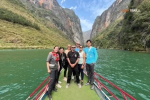
13:30 – Nho Que River Boat Ride
After lunch, the route descends from the highlands toward the Nho Que River. There’s a boat dock in Sung Trai where traditional boats take visitors along a section of the river.
This boat ride is one of the highlights that makes the 4-day itinerary special. The boats are simple wooden vessels with outboard motors, and the ride lasts about 30-40 minutes.
From the water level, you truly appreciate the scale of the canyon walls rising on both sides. The water is impossibly clear and green. The boat operator points out features along the canyon and shares stories about the area.
It’s peaceful on the river, a nice contrast to the riding. Bring a light jacket as it can be cool near the water.
15:00 – M Pass and Lung Ho Viewpoint
Leaving the river, the route continues through mountainous terrain toward Du Gia. The “M Pass” is so-named because when viewed from a distance, the road forms an M shape as it switchbacks up the mountainside.
Lung Ho viewpoint offers another angle on the karst landscape, with dramatic peaks and valleys stretching to the horizon. It’s a quick photo stop before the final stretch to Du Gia.
17:00 – Arrival in Du Gia Village
Du Gia is completely different from the previous two nights. This isn’t a town, it’s a small ethnic minority village in a valley surrounded by rice terraces and mountains.
The homestays here are the most traditional you’ll experience on the loop. They’re often family homes where you stay as a guest, sleeping on mats or simple beds, eating with the family, and experiencing daily village life.
There’s no town center, no restaurants, no shops beyond maybe one small store selling basics. It’s quiet, remote, and peaceful in a way that’s increasingly rare.
Evening – Village Life
Dinner at Du Gia homestays is home-cooked by the host family. The food is simple but genuine: rice, vegetables from the garden, maybe chicken or pork, soup. It’s not fancy but it’s authentic.
After dinner, the evening often involves sitting around talking, perhaps with rice wine being passed around. Kids from the village might come by curious about the visitors. The soundtrack is nature: wind, insects, maybe chickens settling down for the night.
Some homestays have basic electricity, others use generators that run for a few hours then shut off. Bring a headlamp or flashlight. Phone signal is weak or nonexistent in many parts of Du Gia.
This is the night where the loop feels most like an adventure rather than just a scenic motorcycle trip.
Riding Distance: ~130km
Riding Time: 6-7 hours with stops
Highlights: Du Gia waterfall, Duong Thuong valley, Lung Tam linen village
End Point: Ha Giang city
08:00 – Breakfast with a View
Breakfast at the Du Gia homestay often happens on an outdoor patio or balcony overlooking rice terraces. It’s a proper Vietnamese breakfast: pho, banh mi, eggs, fruit, coffee. The setting makes even simple food feel special.
09:00 – Du Gia Waterfall
Before leaving Du Gia, there’s time for a swim at the local waterfall. It’s about 10 minutes from the village, accessible via a short trail through rice fields.
The waterfall isn’t massive but it’s pleasant and the pool below is perfect for swimming. The water is cold, fed by mountain streams, which is refreshing after several days of riding. Bring a swimsuit if you want to swim, though some people just wade in or skip it if they’re not interested.
This swim stop takes about an hour, giving you a relaxed start to the final day rather than immediately jumping on the bikes.
10:30 – Duong Thuong Valley
Leaving Du Gia, the route passes through Duong Thuong valley, an area of H’Mong villages and terraced fields. The valley is wide and green, a contrast to the dramatic cliff-edge riding of previous days.
This is agricultural land, and depending on the season you might see planting, harvesting, or plowing. Buffalo are common sights, along with locals working the fields in traditional clothing.
The riding here is relatively easy, following valley roads with gentle curves.
12:30 – Lunch in Thai An
Thai An is a small town where the lunch stop happens. There are a few restaurants, nothing fancy, serving the usual Vietnamese dishes. By this point in the trip, you probably have your favorites figured out.
14:00 – Lung Tam Linen Village
After lunch, the route includes a stop at Lung Tam village, known for traditional linen weaving. The H’Mong women here grow flax, process it into linen, dye it with natural colors, and weave it into fabric using traditional looms.
You can watch the weaving process, see how the natural dyes are made from plants, and buy finished products like scarves, bags, or fabric by the meter. The quality is genuinely high, and prices are reasonable since you’re buying directly from the weavers.
Allow about 30-45 minutes here. It’s a cultural stop that adds depth to the trip beyond just landscapes.
15:00 – Forest Road Along Mien River
The final stretch back to Ha Giang follows a forest road along the Mien River. This section is scenic in a different way from the high mountain passes, with trees creating a canopy over the road and the river visible through the vegetation.
The riding is straightforward, mostly downhill or flat, which is welcome since by day four most people are feeling the accumulated kilometers in their legs and backsides.
16:30 – Arrival in Ha Giang City
You’ll arrive back at the starting point in Ha Giang city mid-to-late afternoon. There’s usually time to shower, pack up your stuff, and relax before either catching a night bus back to Hanoi or staying another night in Ha Giang.
Most people are tired but satisfied by the end of day four. The loop has a way of feeling like a significant accomplishment, partly because it is. You’ve covered over 450km of challenging mountain roads and experienced a part of Vietnam that’s completely different from the beaches and cities most tourists see.

Learn more: Ha Giang Loop 2 Days 1 Night
While the entire loop is scenic, certain places stand out as the absolute highlights worth special mention.

Learn more: Ha Giang Loop Tours
If you only remember one part of the Ha Giang Loop, it’ll probably be Ma Pi Leng. This 20km section of road between Dong Van and Meo Vac is consistently rated as one of the most beautiful mountain roads in the world, and the reputation is deserved.
The pass reaches over 2000 meters elevation, with the road carved directly into limestone cliffs. On a clear day, the visibility extends for miles, and you can see the Nho Que River hundreds of meters below, its turquoise water winding through the canyon.
What makes Ma Pi Leng special isn’t just the views, it’s the feeling of riding or driving along it. There’s a sense of exposure and scale that’s hard to describe. You feel small against the landscape in a way that’s humbling but also exhilarating.
Photography on Ma Pi Leng is challenging because the road is narrow and parking spots are limited. There are designated viewpoints, but sometimes the best views are from the road itself. If you’re a passenger or on an easy rider tour, you can take photos while moving. Self-drivers need to be more careful about stopping safely.
Weather dramatically affects the Ma Pi Leng experience. On foggy days, visibility drops to meters and the pass feels mysterious and slightly ominous. On clear days, it’s all about the expansive views. Both have their appeal, but most people prefer clear weather for this section.

The Dong Van Karst Plateau is a UNESCO Global Geopark, recognized for its geological significance and the way human cultures have adapted to the karst landscape.
Karst terrain is formed when water dissolves limestone over millions of years, creating distinctive features like sinkholes, caves, towers, and underground rivers. The Dong Van plateau is one of the largest karst areas in Vietnam, with formations dating back hundreds of millions of years.
What this means for travelers is a landscape unlike anywhere else. Rocky peaks rise abruptly from valleys, farmland exists in pockets between stone, and caves honeycomb the mountains.
The ethnic minorities who live here, primarily H’Mong, Tay, and Dao people, have developed unique adaptations to the difficult terrain. Villages are built on whatever flat land exists, fields are terraced into mountainsides, and houses use stone from the mountains for construction.
Riding through the geopark, you’re seeing both natural and cultural heritage. The UNESCO designation has brought some development and tourism infrastructure, but much of the plateau remains relatively unchanged from decades ago.

Read more: Ha Giang Jeep Tours comlete guide
Standing at Vietnam’s northernmost point has symbolic significance for many Vietnamese people, and for travelers, it represents reaching a geographical extreme.
The flag tower itself was built in 2010, replacing an older structure. It’s 54 meters tall, with the number representing Vietnam’s 54 ethnic groups. The Vietnamese flag at the top is massive, visible from kilometers away.
The 400-step climb to the tower is steep but manageable for most people. Along the way, there are information panels about the ethnic minorities of the region and the significance of the location.
At the summit, you can see into China across the valley. The border runs along a river visible from the tower. On the Vietnamese side, the landscape is green and farmed. The Chinese side looks similar, a reminder that political borders don’t change geography.
The Lung Cu area has developed significantly for tourism in recent years, with parking facilities, vendors, and photo opportunities. It’s more commercialized than some other stops on the loop, but the location itself remains impressive.

The Nho Que River is the defining feature of the eastern Ha Giang landscape. It flows from China, cutting through Vietnam’s northern mountains before eventually joining the Gam River.
What makes the Nho Que remarkable is its color: a bright turquoise green that seems almost artificial. This color comes from limestone minerals dissolved in the water. Depending on the season and rain levels, the color intensity varies, but it’s always distinctive.
Tu San Canyon, carved by the Nho Que River, is one of Southeast Asia’s deepest canyons at roughly 800 meters from rim to river. The canyon walls are vertical limestone cliffs, and the river far below looks tiny from the viewpoints above.
The boat ride on the Nho Que is the best way to experience the river up close. From water level, the canyon walls rise dramatically on both sides, and you appreciate the scale in a way that’s not possible from above. The boat operators know the river intimately, navigating around rocks and pointing out features along the way.
During the dry season, the river is calmer and clearer. During the wet season, it flows faster and the color can be murkier, but waterfalls appear on the canyon walls that aren’t there the rest of the year.

Learn more: Cao Bang Loop Tours Vietnam best kept secret
There are three main ways to do the Ha Giang Loop, each with different experiences, skill requirements, and price points.
An easy rider tour means you ride as a passenger behind an experienced local rider who handles all the driving. Your guide is also your rider, and they know the roads, the best stops, and the local culture.
Advantages:
Disadvantages:
Easy rider tours work well for solo travelers who want to join a group, couples where one person doesn’t ride, and anyone who’s honest about their motorcycle skills and knows they’d struggle with technical mountain riding.
The quality of easy rider experiences varies based on your guide. Good guides are knowledgeable, safe riders who balance covering the itinerary with allowing flexibility. Less experienced guides might rush through or lack the cultural knowledge that makes the trip educational beyond just scenic.
For the 4-day loop, easy rider pricing is around 3,990,000 – 5,090,000 VND per person depending on group size and season. This includes the guide/rider, bike, fuel, accommodation, most meals, and activities.
Self-drive means you rent a bike and ride it yourself, either independently or as part of a guided group where everyone rides their own bike.
Advantages:
Disadvantages:
Be honest with yourself about your riding ability. Ha Giang roads are not the place to learn. If you’ve never ridden a manual transmission bike, don’t start here. If your experience is limited to flat roads and automatic scooters, the mountains and semi-automatic bikes used here will be challenging.
That said, if you have proper riding experience, the self-drive option is incredibly rewarding. There’s something about actually handling the bike through those mountain passes that makes the accomplishment feel more personal.
Self-drive tours for the 4-day loop cost around 4,190,000 VND per person, including bike rental, fuel, accommodation, most meals, and activities. Some operators include a guide bike that leads the group, others provide GPS tracks and let you ride independently.
Jeep tours put 2-4 people in a private vehicle with a driver who handles all the navigation and driving. This is the most comfortable option and works well for families, older travelers, or those who want the itinerary without the riding.
Advantages:
Disadvantages:
Jeep tours follow the same itinerary as motorcycle tours, stopping at all the main highlights. The experience is different, less physically engaging but still scenic and cultural.
For a 4-day jeep tour, pricing starts around 22,900,000 VND for 4 passengers, which works out to about 5,725,000 VND per person. Smaller groups pay more per person since the base cost is higher.
Choose easy rider if:
Choose self-drive if:
Choose jeep if:
There’s no wrong choice. The best option is the one that matches your experience level, comfort, and what you want from the trip.

Learn more: Ha Giang Cao Bang Loop Jeep tour Guide
Understanding the actual costs helps with budgeting and avoiding surprises. Here’s what the 4-day loop costs across different tour types, plus additional expenses to factor in.
Easy Rider (4 days 3 nights):
Self-Drive (4 days 3 nights):
Private Jeep (4 days 3 nights):
All these packages are based on dorm-style accommodation at homestays. Private room upgrades are available at additional cost.
Bus Transport:
Private Room Upgrade:
Drinks and Snacks:
Souvenirs and Shopping:
Tips:
Travel Insurance:
For a complete 4-day Ha Giang Loop trip including transport from Hanoi and back, meals not included in the tour, drinks, some shopping, and miscellaneous expenses:
These are estimates assuming moderate spending. Budget travelers can do it for less, and those preferring private rooms and more comfort will spend more.

Learn more: Ha Giang Loop Tours
The Ha Giang Loop is an adventure, and like any adventure, it comes with risks. Being aware and prepared reduces those risks significantly.
Ha Giang roads are mountain roads, which means:
Surface Quality: Variable. Major sections have been repaved and are smooth asphalt. Other sections have potholes, loose gravel, or are rough from weather damage. Road conditions can change after heavy rain, with landslides possible during the wet season.
Traffic: Light compared to Vietnamese cities, but sharing the road with trucks, buses, local motorcycles, and livestock is constant. On blind curves around cliff faces, you don’t know what’s coming the other way until you’re in the turn.
Elevation: The roads climb from under 100 meters to over 2000 meters elevation. Switchbacks, hairpin turns, and sustained climbing are normal. Brake management becomes important on long descents.
Weather: Can change quickly. Morning fog is common, afternoon rain is possible during wet season, and temperature drops at higher elevations.
Guardrails: Often absent, especially on older sections of road. A mistake can mean going off a cliff.
If you’re self-driving, these conditions require genuine motorcycle skill. Slow down on unfamiliar sections, brake before turns not in them, and don’t let the scenery distract you from the road.
For easy riders and jeeps, the driver handles these challenges, but be aware of motion sickness potential on winding roads.
Overestimating Your Riding Ability: The most common mistake is people who’ve ridden scooters in Bali or Thailand thinking that’s equivalent preparation. It’s not. Ha Giang requires experience with geared bikes, mountain riding, and traffic judgment.
Riding Too Fast: Trying to keep up with experienced guides when you’re not comfortable leads to crashes. Ride at your own pace. Good guides adjust to the group’s ability level.
Inadequate Sun Protection: Mountain sun is strong, and you’re exposed for hours. Sunburn on the back of your hands, neck, and face is common if you skip sunscreen.
Drinking and Riding: The “happy water” at homestays is strong. If you’re self-driving, be careful about how much you drink the night before a riding day. Hangovers and mountain riding don’t mix well.
Skipping Travel Insurance: If you crash and need medical evacuation from Ha Giang to Hanoi or beyond, costs can be enormous. Insurance that covers motorcycle riding is essential.
Not Checking Your Bike: Before each day, check tire pressure, brakes, lights, and fuel. Small mechanical issues become bigger problems in remote areas.
Ignoring Weather Warnings: If locals or your guide say weather is bad and you should delay, listen. Fog, ice, or heavy rain makes the roads genuinely dangerous.
Peer Pressure: Don’t let group dynamics push you into riding faster or taking risks you’re uncomfortable with. It’s okay to be slower or more cautious.
Minor Crashes/Scratches: Common enough to not be surprising. If you drop your bike on gravel or have a low-speed fall, check yourself for injuries first, then the bike. Most rental bikes are expected to get scratched on the loop.
Significant Crashes: If you or someone in your group crashes seriously, assess injuries first. If medical attention is needed, contact your tour operator immediately. Evacuation from remote areas takes time.
Bike Breakdowns: Most tour operators have backup plans for mechanical failures. A support vehicle might be following the group, or they can arrange for another bike to be brought to your location.
Getting Lost: If you’re self-driving and get off route, stop and check GPS or ask locals. Most people in the region are used to helping lost tourists.
Altitude Sickness: At over 2000 meters, some people experience mild altitude symptoms: headache, nausea, fatigue. It’s usually minor. Stay hydrated, rest if needed, and descend if symptoms worsen.
The key to safety is honest self-assessment and preparation. Know your limits, choose the tour type that matches your ability, and err on the side of caution when conditions are challenging.

Learn more: Ha Giang Loop 4 Days 3 Nights
Accommodation on the Ha Giang Loop is part of the experience. You’re not staying in hotels, you’re staying in homestays with local families, experiencing their daily life and hospitality.
What to Expect from Homestays:
Sleeping Arrangements: Most tour packages include dorm-style accommodation, meaning shared rooms with multiple beds. Beds usually have mattresses and blankets, sometimes pillows. The beds aren’t luxurious but they’re adequate. Private room upgrades are available at some homestays for additional cost, though availability is limited in smaller villages like Du Gia.
Bathrooms: Shared bathrooms are standard. Most have hot water, though “hot” is relative and might be lukewarm. Toilets are squat or western-style depending on the homestay. Bring your own towel as they’re not always provided. Toilet paper is usually available but carrying your own is wise.
Electricity: Varies by location. Yen Minh and Dong Van have consistent electricity. Du Gia is more remote and may have limited electricity from generators that run certain hours. Charge your devices when you have the opportunity.
WiFi: Available in some homestays in Yen Minh and Dong Van, usually weak. Du Gia typically has no WiFi. Phone signal is inconsistent throughout the loop, strongest in towns and weakest in remote villages.
Atmosphere: Homestays are family homes. You’ll hear kids playing, chickens in the yard, conversations in local languages, dogs barking, cooking sounds from the kitchen. It’s authentic village life, not quiet like a hotel.
Cleanliness: Standards vary. Some homestays are meticulously clean, others are more basic. The definition of “clean” in a mountain farming village is different from urban standards. Set appropriate expectations.
Night One – Yen Minh:
Yen Minh homestays are relatively developed for tourism. They have multiple rooms, can accommodate larger groups, and generally have hot showers and consistent electricity. These homestays often have balconies or outdoor seating areas with mountain views.
Night Two – Dong Van:
Dong Van offers more variety since it’s a larger town. Some homestays are in traditional old quarter buildings with character and history. Others are newer structures. Comfort level is generally good, and hot showers are reliable.
Night Three – Du Gia:
Du Gia homestays are the most basic and most authentic. These are small family homes in a farming village. Accommodation is simple, electricity might be limited, and hot water isn’t guaranteed. But the experience of staying in such a remote location, with rice terraces outside your window and absolute quiet at night, is unique.

Learn more: Ha Giang Loop 4 Days 4 Nights itinerary
Booking your Ha Giang Loop tour can be done in advance or upon arrival in Ha Giang, each approach with advantages.
Booking in Advance:
The safest option is booking before you arrive, especially during high season (September-November). This guarantees availability, allows you to compare operators, and gives you time to ask questions about the itinerary and what’s included.
For Loop Trails tours, you can book directly through the website or via WhatsApp. The booking process typically involves:
Booking in advance also allows you to coordinate your Hanoi to Ha Giang bus ticket to align with your tour start time.
Booking Upon Arrival:
Some travelers prefer to book in Ha Giang city after arriving, which allows you to meet operators in person, see the bikes, and potentially negotiate prices during low season.
If taking this approach:
During peak season, same-day bookings might not be available as tours fill up.
What to Look For in a Tour Operator:
Questions to Ask Before Booking:
Deposit and Payment:
Most operators require a deposit to secure your booking, with the balance due before the tour starts. Payment methods vary – some accept card payments, others prefer cash or bank transfer. Clarify this when booking.
For Loop Trails bookings, reaching out via WhatsApp allows quick responses to questions and straightforward booking coordination.
The Ha Giang Loop is challenging for beginner riders. If your experience is limited to flat roads or automatic scooters, self-driving the loop is not recommended. The roads include steep climbs, hairpin turns, variable road surfaces, and significant traffic challenges. For beginners or less experienced riders, an easy rider tour (riding as a passenger) is the safer choice. You still experience the full loop without the riding responsibility.
Yes, the 3-day loop is possible and covers most major highlights. However, you’ll miss some experiences like Lung Khuy Cave, the extended time at Vuong Palace, Du Gia waterfall, and Lung Tam linen village. The 3-day itinerary also feels more rushed with longer daily riding distances and less flexibility for spontaneous stops. If you have the time, the 4-day version is more relaxed and comprehensive.
September through November offers the best combination of weather, scenery, and road conditions. October is peak season with golden rice terraces and clear weather. December to February is cold but less crowded. March to May has comfortable temperatures and flowering buckwheat. June to August is rainy season with green landscapes but more challenging riding conditions. Choose based on your priorities: best weather and scenery (Sept-Nov), fewer tourists (Dec-Feb), or budget travel (June-Aug).
Legally, yes. Vietnam requires an International Driving Permit with category A endorsement or a Vietnamese license for bikes over 50cc. Enforcement varies, but riding without proper licensing means your travel insurance won’t cover accidents. Easy rider tours solve this since you’re a passenger, not the rider. For self-drive tours, you’re responsible for having appropriate documentation. Check your insurance policy before deciding.
Yes, many solo female travelers complete the Ha Giang Loop without issues. Joining a guided tour (easy rider or self-drive group) provides safety in numbers and local knowledge. Homestays are family-run and generally safe. Basic precautions apply: don’t leave valuables unattended, trust your instincts about situations, and stay with your group. The bigger safety concern is riding skill rather than personal security. If you’re not comfortable riding solo, an easy rider tour offers both safety and local companionship.
Light rain doesn’t usually stop tours. You’ll be provided with rain gear, and riding continues with more caution and slower speeds. Heavy rain or dangerous conditions might cause delays or route modifications. Good operators prioritize safety over schedule. If weather is genuinely bad, waiting for it to clear is normal. The wet season (June-August) has more rain days, but the landscape is intensely green and waterfalls are at their best. Bring waterproof bags for valuables.
Yes, you can rent a bike in Ha Giang and ride independently using GPS tracks or maps. This gives maximum flexibility but requires strong navigation skills, mechanical knowledge for basic repairs, and confidence riding without support. If you break down or get lost, you’re handling it yourself. Most solo independent riders have significant motorcycle touring experience. If this is your first multi-day motorcycle trip, joining a guided tour is wiser.
Bring enough Vietnamese Dong to cover drinks, snacks, souvenirs, tips, and any additional expenses. ATMs exist in Ha Giang city and Dong Van but are unreliable in smaller towns. Card payments are rare at homestays and local shops. Budget around 500,000 – 1,000,000 VND in cash beyond your tour payment depending on your spending habits. Bring extra as a buffer since getting more cash in remote areas is difficult.
For self-drive tours, you must be old enough to legally ride a motorbike (typically 18+). Easy rider tours accept passengers of any age who can safely sit behind the rider. Jeep tours have no age restrictions and work well for families with children. Physical fitness is more relevant than age – the days are long, and accommodation is basic. Assess honestly whether you’re comfortable with the physical demands regardless of age.
For guided tours, operators usually have support systems – either a vehicle following the group or arrangements with local mechanics. If you crash, assess injuries first. For significant injuries, operators contact medical services for evacuation. Minor crashes resulting in scratches or drops are common and expected. For mechanical breakdowns, guides coordinate bike swaps or repairs. If you’re riding independently, you’re responsible for handling these situations yourself. This is why comprehensive travel insurance covering motorcycle riding is essential.
Yes, though options are limited compared to Vietnamese cities. Homestay meals are communal and family-style, but vegetarian versions can be arranged if you inform your tour operator in advance. Rice, vegetables, tofu, and eggs are readily available. Vegan options are more challenging since fish sauce and animal products are common in Vietnamese cooking, but it’s possible with advance notice. The earlier you communicate dietary requirements, the better homestays can prepare.
Phone signal is inconsistent. Ha Giang city, Yen Minh, Dong Van, and Meo Vac have reliable signal. Remote areas, mountain passes, and small villages like Du Gia often have weak or no signal. Viettel has the best coverage in northern Vietnam. Don’t rely on constant connectivity. Download offline maps before starting and inform people you’ll be out of contact for periods. WiFi at homestays is rare and usually slow where it exists
Contact information for Loop Trails
Website: Loop Trails Official Website
Email: looptrailshostel@gmail.com
Hotline & WhatSapp:
+84862379288
+84938988593
Social Media:
Facebook: Loop Trails Tours Ha Giang
Instagram: Loop Trails Tours Ha Giang
TikTok: Loop Trails
Office Address: 48 Nguyen Du, Ha Giang 1, Tuyen Quang
Address: 48 Nguyen Du, Ha Giang 1, Tuyen Quang
Facebook X Reddit Table of Contents Learn more: Ha Giang Loop Tours There’s a moment, usually somewhere on Ma Pi Leng Pass,
Facebook X Reddit Table of Contents Learn more: Ha Giang Loop Tours There’s a version of the Ha Giang Loop that people
Facebook X Reddit Table of Contents Learn more: Ha Giang Loop Tours There’s a moment on the Ma Pi Leng Pass —