

Ha Giang Easy Rider: The Complete Guide (2026)
Facebook X Reddit Table of Contents Learn more: Ha Giang Loop Tours There’s a moment, usually somewhere on Ma Pi Leng Pass,

Thúy Kiều (Grace) is a travel blogger and content contributor for Loop Trails Tours Ha Giang. She holds a bachelor’s degree in Sustainable Tourism from Vietnam National University, Hanoi, and has a strong passion for exploring and promoting responsible travel experiences in Vietnam’s northern highlands.
The Ha Giang Loop isn’t just another motorbike route—it’s the road trip that shows up in every “best of Vietnam” list for a reason. Carving through the country’s northernmost mountains, this roughly 350km circuit takes you past limestone karsts that jut into clouds, valleys where minority villages have farmed for centuries, and roads that switchback so dramatically you’ll forget which direction is north.
But here’s what those Instagram posts don’t always show: the Ha Giang Loop route requires planning. The roads shift from smooth asphalt to gravel patches, the weather can flip from sunshine to fog in an hour, and getting lost on unmarked mountain roads is easier than you’d think.
This guide breaks down the entire route—what you’ll actually see each day, where the road gets tricky, when to go, and how to choose between riding yourself or joining a tour. No fluff, just the practical info you need to plan your trip.

Learn more: Ha Giang Motorbike Rental

Learn more: Ha Giang Loop for Families & Groups
The Ha Giang Loop is a circular motorbike route through Ha Giang Province in northern Vietnam, starting and ending in Ha Giang City. The route takes you through the Dong Van Karst Plateau Geopark—a UNESCO-recognized area known for dramatic mountain landscapes, ethnic minority villages, and roads that rank among the most scenic in Southeast Asia.
Most travelers complete the loop in 3-4 days, though you could rush it in 2 or extend it to a week with side trips. The circuit runs roughly 300-350km depending on detours, passing through main stops like Quan Ba, Yen Minh, Dong Van, Meo Vac, and Du Gia before looping back to Ha Giang City.
I’ve ridden motorbike routes across Vietnam—Hai Van Pass, Central Highlands, the Mekong—and the Ha Giang Loop still stands apart. Here’s why it earns that reputation:
The landscapes actually change. You’re not staring at the same scenery for hours. One minute you’re winding through rice terraces in the Quan Ba Valley, the next you’re climbing into barren karst formations that look more like Mars than Vietnam. Then you drop into the Nho Que River canyon where the water runs turquoise between sheer cliffs.
It’s remote without being inaccessible. You’ll pass through Hmong, Tay, and Lo Lo villages where locals still wear traditional clothing daily—not for tourists, just because that’s life. Yet there’s guesthouses, phone signal (mostly), and mechanics in the main towns. It’s the sweet spot of adventure and infrastructure.
The roads are genuinely fun to ride. The Ma Pi Leng Pass alone justifies the trip. Twenty kilometers of clifftop switchbacks carved into the mountainside, with drops so steep you’ll white-knuckle the brakes even if you’re confident on a bike.
It hasn’t been completely overrun yet. Sure, tourism has grown, especially in October and November. But you’ll still have long stretches where it’s just you, the mountains, and maybe a water buffalo blocking the road.
Standard answer: 3 days, 2 nights. This is what most tours run and what works for most people. You’re riding 100-120km per day, which sounds short but takes 4-6 hours once you factor in photo stops, rough road sections, and getting turned around in villages.
Comfortable pace: 4 days, 3 nights. Add an extra day and you can explore side routes, visit the Sunday market in Dong Van or Meo Vac, hike to viewpoints, or just ride without rushing. This is what I’d recommend if you have the time.
Rush option: 2 days, 1 night. Possible but exhausting. You’ll spend most of your time on the bike and miss half the scenery because you’re focused on making it to the next town before dark. Only worth it if you’re truly short on time.
Extended route: 5-7 days. Combine the Ha Giang Loop with nearby areas like Cao Bang (Ban Gioc Waterfall, Nguom Ngao Cave) or add northern detours to less-traveled roads around Hoang Su Phi or Bac Ha. This turns it into a proper northern Vietnam adventure.

Learn more: Ha Giang Loop 3 Days 2 Nights
Before diving into daily breakdowns, let’s look at the big picture. The Ha Giang Loop is a circuit, so you can technically start anywhere, but 95% of people begin and end in Ha Giang City because that’s where the bus from Hanoi drops you off.
This is the standard route that most tours and self-drive riders follow:
Total distance: Approximately 320-350km
Main route: Ha Giang City → Tam Son → Quan Ba → Yen Minh → Dong Van → Meo Vac → Ma Pi Leng Pass → Du Gia → Ha Giang City
Overnight stops:
The route follows Highway QL4C for much of the journey, which is the main road through the region. It’s mostly paved but expect sections of gravel, potholes, and ongoing construction work—especially after heavy rain.
Adding a fourth day gives you flexibility. Here are the most popular options:
Option 1: Slower pace with side trips
Option 2: Southern extension
Option 3: Cao Bang combination
The 4-day pace works better for first-time riders or anyone who wants to actually experience the places you’re passing through instead of just collecting viewpoint photos.
Here’s what the riding actually looks like. Times are estimates—your speed depends on road conditions, traffic (water buffalo count as traffic), photo stops, and how confident you are on mountain curves.
Ha Giang City → Quan Ba (Heaven’s Gate): 45km, 1.5-2 hours
Quan Ba → Yen Minh: 50km, 1.5-2 hours
Yen Minh → Dong Van: 50km, 2-3 hours (slower due to road conditions)
Dong Van → Lung Cu Flag Tower (detour): 25km each way, 1 hour each way
Dong Van → Meo Vac: 25km, 1.5-2 hours
Meo Vac → Ma Pi Leng viewpoint: 15km, 30-45 minutes
Ma Pi Leng → Du Gia: 50km, 2-2.5 hours
Du Gia → Ha Giang City: 100km, 3-4 hours
Notice how short distances take longer than you’d expect. That’s mountain riding. The 50km from Yen Minh to Dong Van can take 3 hours if you’re cautious on corners or stuck behind a truck on single-lane sections.
Pack snacks and start early. Riding after dark on these roads is both illegal and genuinely dangerous—no street lights, unpredictable livestock, and cliff edges with minimal barriers.

Learn more: Ha Giang Loop 4 Days 3 Nights
Let’s walk through what you’ll actually see and ride each day, along with where the route gets tricky and what’s worth stopping for.
Distance: 95-100km
Riding time: 3-4 hours
Difficulty: Easy to moderate
You’ll leave Ha Giang City heading north on QL4C. The first 20km is easy riding—flat roads, some traffic, nothing dramatic. Then you start climbing toward Quan Ba.
Quan Ba Heaven’s Gate (Cổng trời Quản Bạ) is your first real viewpoint, about 45km from Ha Giang City. It’s a tourist stop with a ticket booth, shops selling grilled corn, and a viewing platform overlooking the Fairy Mountain twin peaks (Núi Đôi Cô Tiên). The view is worth the stop, especially if it’s clear. Early morning gives you better chances of seeing the valley without fog.
From Quan Ba, the landscape shifts. You’re riding through terraced valleys with Hmong villages scattered on hillsides. The road quality varies—some smooth sections, some gravel patches where they’re resurfacing.
Yen Minh town is where most 3-day tours stop for the night. It’s a small mountain town with basic guesthouses, local restaurants, and not much else. Some tours push on to Dong Van for Night 1, which is a longer ride (150km total) but puts you closer to Day 2 highlights.
Stops worth making:
Road notes: Mostly paved with some gravel sections. Watch for gravel around blind corners—your tires can slip. The climb to Heaven’s Gate has steep sections but nothing terrifying.
Distance: 75-100km (depending on detours)
Riding time: 4-6 hours
Difficulty: Moderate to challenging
This is the day that earns the Ha Giang Loop its reputation. You’ll ride through the heart of the Dong Van Karst Plateau, visit the northernmost point of Vietnam, and cross some of the most dramatic mountain roads in the country.
Yen Minh → Dong Van (50km): The road gets rougher here. You’re still on QL4C but expect gravel sections, potholes, and narrow passages where onlookers have to wait for trucks to pass. The landscape is increasingly barren—towering limestone karsts, rocky fields, scattered pine trees. It feels lunar.
Dong Van town sits in a valley surrounded by karst peaks. It’s the main hub in the region with a Sunday market (huge if you’re there on the right day), an old quarter with French colonial buildings, and the Vuong family palace—a historic mansion built by a Hmong opium trader in the early 1900s.
Lung Cu Flag Tower detour (50km round trip): This is Vietnam’s northernmost point, marked by a giant flag tower on a hilltop right at the Chinese border. The detour adds 50km total (25km each way) and takes 2 hours minimum. Worth it if you care about “I reached the top of Vietnam” moments or want views of the border region. Skip it if you’re short on time or weather’s bad—the road can be treacherous in rain.
Dong Van → Meo Vac (25km): Short distance but this is where the landscape gets wild. You’re climbing through high-altitude passes with massive karst formations on all sides. The Happiness Road (Đường Hạnh Phúc) connecting Dong Van and Meo Vac was hand-carved through the mountains in the 1960s and still has sections that feel like they’re barely clinging to the cliff.
Meo Vac town is smaller than Dong Van, quieter, with a Sunday market of its own. Most tours overnight here.
Stops worth making:
Road notes: This is the most challenging day. Gravel, tight corners, steep climbs, occasional landslide debris. Ride defensively. If there’s fog, slow down—visibility drops to 20 meters and you won’t see oncoming vehicles until you’re right on them.
Distance: 150-160km
Riding time: 5-7 hours
Difficulty: Moderate
This is the long day, but also the day you ride Ma Pi Leng Pass—the crown jewel of the entire loop.
Meo Vac → Ma Pi Leng Pass (15km): You’ll climb out of Meo Vac on a road that immediately starts switchbacking up the mountainside. Within 15km you’re on top of the world, riding a road carved into a near-vertical cliff face 2,000 meters above the Nho Que River.
Ma Pi Leng Pass is legitimately one of the best stretches of road in Southeast Asia. Twenty kilometers of clifftop riding with the Nho Que River canyon dropping away to your right. There are viewing platforms where you can stop and stare. Do it. Photos don’t capture the scale—the river looks like a thin green ribbon from up here.
The pass has been improved in recent years with barriers and better asphalt, but it’s still a serious ride. Sections have sheer drops with minimal fencing. If you’re nervous about heights, this will test you. If you love mountain riding, this is the highlight of the trip.
Nho Que River viewpoint: About halfway through Ma Pi Leng, there’s a purpose-built viewpoint platform that juts out over the canyon. Costs a small fee to enter but gives you the best vantage point for photos. Tour groups cluster here around 10-11am, so arrive early or late if you want it quieter.
Du Gia town: After descending from Ma Pi Leng, you’ll reach Du Gia, a small riverside town where the road flattens out and the landscape shifts back to green. Some tours stop here for Night 2, others push through to Ha Giang City.
Du Gia → Ha Giang City (100km): The long cruise back. The road is mostly smooth here, running through valleys and alongside rivers. It’s less dramatic than the previous days but a welcome break for your arms and attention span. You’ll pass through small towns and farming communities, eventually rejoining civilization as you approach Ha Giang City.
Stops worth making:
Road notes: Ma Pi Leng is the highlight but also the hazard. Ride carefully, especially around tour buses that take up the whole lane on corners. The descent after the pass is steep—control your speed with gears, not just brakes. The road back to Ha Giang is easier but watch for gravel trucks.

Learn more: Ha Giang Cao Bang 5 Days
If you’ve got an extra day, here are the best ways to use it:
Sunday markets: If your timing works out, spend the morning at either Dong Van or Meo Vac Sunday market. These are real markets where ethnic minority groups from surrounding villages come to trade, socialize, and buy supplies. You’ll see traditional clothing, livestock trading, and food vendors selling things you won’t find anywhere else. It’s crowded, chaotic, and fascinating.
Hoang Su Phi rice terraces: From Du Gia, you can detour south to Hoang Su Phi and Xin Man to see rice terraces that rival Sapa. This adds 100km+ but gives you a completely different landscape. Best from May to September when the rice is growing.
Cao Bang combination: The most popular extension. From Ha Giang, ride east to Cao Bang Province to visit Ban Gioc Waterfall (Vietnam’s largest waterfall on the Chinese border) and Nguom Ngao Cave. This requires 2-3 additional days and adds roughly 300km to your total route.
Local village homestays: Instead of sticking to towns, arrange a homestay in a more remote village. This is easier to coordinate if you’re on a tour, but self-drive riders can ask locals or follow signs for “homestay” in villages along the route.

Learn more: Ma Pi Leng Pass
Beyond the daily route, here are the specific spots that define the Ha Giang Loop experience.
There’s a reason every Ha Giang photo gallery leads with Ma Pi Leng. This 20km stretch of road, built by ethnic minority groups in the 1960s using hand tools and dynamite, runs along a clifftop 1,200 meters above the Nho Que River.
What makes it special isn’t just the views (though those are ridiculous)—it’s the feeling of riding it. You’re navigating tight switchbacks with nothing but air to your right, following a road that seems to defy gravity as it clings to the rock face. The scale is hard to process until you see a boat on the river far below and realize it looks like a toy.
When to visit: Early morning (7-9am) gives you better light and fewer tour buses. Late afternoon works too but watch the time—you don’t want to be navigating this in fading light.
Safety notes: This is not the place to show off. Ride defensively, stay in your lane on corners, and pull over completely if you’re stopping for photos. Tour buses and trucks use this road too, and they don’t have much room to maneuver.
The entire Ha Giang Loop runs through this UNESCO-recognized geopark, which spans over 2,000 square kilometers of karst formations. You’re riding through 400-600 million-year-old limestone that’s been eroded into dramatic peaks, valleys, and caves.
From a riding perspective, this means stunning scenery but also challenging terrain. The karst landscape creates steep gradients, unstable soil (landslides after rain), and limited flat areas for towns or roads.
Geological highlights:
You don’t need to be a geology nerd to appreciate this—the landscapes speak for themselves. But understanding that you’re riding through ancient seabeds pushed up by tectonic forces adds context to why everything looks so alien.

Learn more: Lung Cu Flag Tower Guide
Vietnam’s northernmost point, marked by a giant flag tower visible for kilometers around. To reach it, you’ll detour from Dong Van on a 25km road that climbs to over 1,400 meters elevation.
The tower itself is more symbolic than architecturally interesting—it’s just a tall concrete structure with a huge Vietnamese flag on top. But the views from the hilltop are expansive, and on clear days you can see into China across the border valley.
Worth the detour? If you have time and decent weather, yes. If you’re short on time or it’s foggy/rainy, skip it. The road there and back eats 2 hours minimum and doesn’t offer much beyond the tower itself.

Learn more: Tu San Canyon & Nho Que River
The Nho Que River cuts a canyon through the mountains between Dong Van and Meo Vac, creating one of the most dramatic landscapes on the loop. The river itself is a striking jade-green color thanks to sediment from limestone erosion.
Best viewpoints:
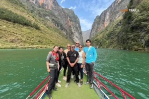
Some tour operators now offer boat trips on the river, paddling through the canyon below the pass. It’s a completely different perspective, though it adds time and cost. Check weather and water levels—the boats don’t run if the river’s too high or if there’s been heavy rain.

Learn more: Ha Giang market days
The Sunday markets in Dong Van and Meo Vac are cultural highlights that most tourists miss simply because they’re not there on the right day. If your schedule allows, plan your route so you’re in one of these towns on Sunday morning.
Dong Van Sunday Market: Larger and more famous, held in the town center. You’ll see Hmong, Tay, and other ethnic groups in traditional clothing, trading everything from livestock to vegetables to handmade textiles. Gets crowded by mid-morning.
Meo Vac Sunday Market: Smaller, more local, less touristy. Similar vibe but feels more authentic because fewer travelers make it here. The market spreads out from the main square into surrounding alleys.
What to expect: These aren’t craft markets for tourists. They’re working markets where locals buy supplies for the week. You’ll see buffalo trading, fermented corn wine in recycled vodka bottles, and foods you won’t identify. Bring cash if you want to buy anything—no one takes cards.
Photography: People are generally okay with photos but ask first, especially for portraits. Some vendors might gesture “no” if they’re not comfortable. Respect that.

Learn more: Ha Giang Cao Bang by Jeep and motorbike
The Ha Giang Loop isn’t technical single-track or extreme off-roading, but it’s also not a highway cruise. Understanding what you’re riding into helps prevent surprises.
Current state (check for updates): The main loop on QL4C is roughly 70-80% paved. The paved sections are generally good quality asphalt, though you’ll encounter potholes, cracks, and patches where road crews have made repairs.
The unpaved sections are usually hard-packed gravel or dirt, not loose sand or mud (unless there’s been heavy rain). These tend to be shorter stretches—1-5km at a time—often appearing where landslides have damaged the road or construction work is ongoing.
Where you’ll hit gravel/dirt:
Road conditions change. New sections get paved, landslides create new rough patches, construction work blocks lanes. If you’re self-driving, ask locals or check recent traveler reports for current conditions on specific sections.
Not all kilometers are created equal on the Ha Giang Loop. Here’s how the difficulty breaks down:
Easy sections:
Moderate sections:
Challenging sections:
If you’re a confident rider with some experience on mountain roads, you’ll handle the moderate sections fine. The challenging sections require focus—no phone checking, stay alert, and if you’re uncomfortable, slow down. There’s no shame in taking Ma Pi Leng at 20kph if that’s what feels safe.
If you’re a beginner or nervous rider, seriously consider an Easy Rider tour where someone else handles the bike and you ride pillion. The roads are rideable for beginners but one mistake on Ma Pi Leng isn’t forgiving.
Weather transforms the Ha Giang Loop from challenging to genuinely dangerous. Here’s what different conditions mean for riding:
Rain: Makes gravel sections slippery and reduces visibility on mountain curves. Light rain is manageable with caution. Heavy rain creates waterfalls across the road, flash flooding in valleys, and landslide risk. If there’s been sustained heavy rain, consider delaying or changing routes.
Fog: Common in early mornings and after rain, especially at high elevations around Dong Van and Ma Pi Leng. Visibility can drop to 20-30 meters. If you’re caught in fog, slow way down—you won’t see oncoming vehicles or road edges until you’re right on them.
Cold: October to March can be genuinely cold at elevation (5-10°C), especially early morning. Cold hands reduce your ability to brake and shift effectively. Pack layers and gloves even if Ha Giang City feels warm.
Wind: The high passes can have strong crosswinds that push you around. Not common but worth knowing if you’re on a lighter bike.
The safest approach: start early (6-7am), ride during daylight hours, and be flexible. If weather turns bad midday, find a guesthouse and wait it out rather than pushing through.

Learn more: Ha Giang in September & October
Timing your visit changes everything. The Ha Giang Loop is rideable year-round, but the experience varies dramatically by season.
October – November (Peak Season)
This is when everyone goes, and for good reason—the weather is reliable and the buckwheat fields turn entire valleys pink and white.
December – February (Winter)
If you can handle the cold, winter offers a completely different Ha Giang—quieter, harsher, more atmospheric.
March – May (Spring)
Solid shoulder season. You’ll avoid the October rush while still getting decent weather.
June – September (Summer/Monsoon)
Summer gets skipped by most international tourists, but it has advantages—the rice terraces are vibrant green and you’ll have viewpoints to yourself. Just be ready for wet riding conditions.
If rice terraces are your main draw, timing matters:
May – June: Planting season. Terraces are flooded, reflecting sky and mountains like mirrors. Stunning for photography.
July – August: Growing season. Everything is bright green, lush, and dramatic.
September – October: Harvest season. Terraces turn golden yellow as the rice ripens. Peak beauty.
November – April: Dry/fallow season. Terraces are brown and less photogenic, though the mountain scenery still delivers.
Late October to early November is buckwheat season, when the fields around Dong Van and Lung Cu turn pink and white with flowers. It’s Ha Giang’s signature photo op and draws massive crowds.
If you’re planning for buckwheat, book accommodations weeks in advance and expect higher prices. The flowers peak for about 2-3 weeks, usually late October, but timing varies year to year based on weather.

Learn more: Ha Giang Loop Easy Rider
You’ve got three main ways to tackle the Ha Giang Loop, each with different tradeoffs in cost, freedom, safety, and experience.
How it works: You ride pillion (back seat) on a semi-automatic motorbike while an experienced local driver handles navigation, road conditions, and all the riding. These are called “Easy Rider” tours, a term borrowed from the Central Highlands tours but now used throughout Vietnam.
Typical setup:
Who it’s for:
Pros:
Cons:
What to expect: Your driver will likely be a young local guy (Tay, Hmong, or Kinh) from the region who’s been running this route for years. Good drivers point out viewpoints, explain local culture, and get you to guesthouses safely. Less good drivers just get you from A to B. Read reviews or ask for recommendations before booking.
How it works: Rent a motorbike in Ha Giang City, ride it yourself, navigate with maps/GPS, find your own accommodation along the way. Maximum freedom, maximum responsibility.
Typical setup:
Who it’s for:
Pros:
Cons:
License reality check: Vietnam law requires an International Driving Permit (IDP) with motorcycle category or a Vietnamese license to legally ride. In practice, enforcement varies. Ha Giang has checkpoints, especially on the main roads, and police do check licenses. Getting caught without one means fines (negotiable) and potentially having the bike confiscated until you pay. Some rental shops rent to anyone, others are stricter. Your insurance (if you have travel insurance) likely won’t cover accidents if you don’t have proper license.

Learn more: Ha Giang Jeep Tours
How it works: Same route as motorbike tours but in a 4-seater jeep or car with a driver. You sit back and ride in comfort while someone else navigates.
Who it’s for:
Pros:
Cons:
Reality check: If you’re physically able to ride a motorbike and aren’t traveling with kids, the jeep option misses what makes the Ha Giang Loop special. You’re watching the landscape through a window instead of being in it. But if mobility, safety, or weather is a genuine concern, it’s a solid alternative to skipping Ha Giang entirely.
Here’s how to choose:
Go Easy Rider tour if:
Go self-drive if:
Go jeep/car if:
Still unsure? Start with a single-day Easy Rider trip from Ha Giang City to test your comfort level with the roads and riding conditions. If it feels manageable, switch to self-drive for Days 2-3. If it feels sketchy, stick with the tour.

Learn more: Ha Giang Loop Solo Travel
Let’s address the elephant on the road: licensing and police.
The law: Vietnam requires riders to have either a Vietnamese motorbike license or an International Driving Permit (IDP) with Category A (motorcycle) endorsement. Technically, your home country motorcycle license alone is not valid.
The reality: Enforcement is inconsistent. Ha Giang Province has active checkpoints, especially on the main routes, where police do check licenses and registration. They’re particularly active during peak season (October-November) and around major towns.
What happens if you’re caught without proper license:
Some travelers ride the entire loop without seeing police. Others get stopped multiple times. It’s a gamble.
Options:
My take: If you’re planning to self-drive, get the IDP. It’s cheap insurance against both fines and the stress of wondering if you’ll get stopped.
Registration: The rental bike should come with registration papers (blue card). Keep it with you. If stopped, police check both your license and the bike’s registration. Missing either causes problems.
The Ha Giang Loop isn’t wilderness camping, but you’re riding through mountains with limited shopping options. Pack accordingly.
Essential riding gear:
Clothing:
Practical items:
Photography:
What to leave behind:
Pack everything in a waterproof bag or dry bag. Even if it doesn’t rain, dust from the roads gets into everything.

Learn more: Ha Giang Loop for Couples
The Ha Giang Loop isn’t wilderness—every town along the route has guesthouses, and even small villages have homestay options.
Main towns with accommodation:
What to expect:
Quality standards: Don’t expect boutique hotels. Even the “nicer” places are simple. Beds are firm, showers are hot (usually), wifi works (sometimes). It’s functional, not luxurious.
Booking: During peak season (October-November), book ahead for Dong Van and Meo Vac—rooms fill up. During other months, you can usually find something by just showing up. Tours handle accommodation for you.
Homestays: These are in local villages, often Hmong or Tay families who’ve converted part of their home for guests. You’ll sleep on firm mattresses in shared rooms, eat family-style meals, and get a more authentic cultural experience. Facilities are basic (squat toilets, cold showers common). It’s not for everyone but can be the highlight of the trip if you’re open to it.
The Ha Giang Loop is safe in the sense that violent crime is virtually non-existent and people are friendly. It’s risky in the sense that the roads are demanding and consequences for mistakes are serious.
Riding safety:
Common riding mistakes:
Health safety:
Scam awareness: The Ha Giang Loop isn’t a scam hotspot, but a few things to watch:
Emergency contacts:
Most importantly: ride within your ability. The Instagram photo from the cliff edge isn’t worth the hospital visit.

Learn more: Ha Giang Loop Cost & Tips
Ha Giang Loop costs vary wildly depending on how you do it. Here’s realistic budgeting:
Easy Rider Tour (3 days):
Self-Drive Motorbike (3 days):
Jeep Tour (3 days):
Additional costs to factor:
Money-saving tips:
Where to spend more:
Bring cash. ATMs exist in Ha Giang City, Dong Van, and Meo Vac, but they sometimes run out during peak season. Smaller towns and villages are cash-only. Most places don’t take cards.

Learn more: Ban Gioc Waterfall Guide
If you’ve got 5-7 days, combining Ha Giang Loop with Cao Bang creates an epic northern Vietnam circuit that covers the region’s two biggest highlights.
The combined route:
What Cao Bang adds:
Logistics:
Is it worth adding?
The combination works best as a 6-7 day trip with comfortable pacing. Any shorter and you’re just collecting stamps rather than experiencing the places.
That’s the Ha Giang Loop route from end to end—what you’ll ride, what you’ll see, how to prepare, and what actually matters when you’re out there navigating mountain roads with a cliff on one side and a limestone tower on the other.
The loop earns its reputation not because it’s the most extreme or technical ride, but because it combines accessible adventure with genuinely stunning landscapes and a route that makes sense for a 3-4 day trip. You don’t need to be an expert rider, but you do need to respect the roads. You don’t need a massive budget, but you do need to plan intelligently.
Whether you’re gripping the handlebars yourself on Ma Pi Leng or riding pillion behind a local guide who knows every pothole by name, the Ha Giang Loop delivers what it promises: a road trip through mountains that look like they belong in a fantasy novel, villages where life moves at a different pace, and corners that make you simultaneously nervous and exhilarated.
Pack your helmet, check the weather, make sure your camera’s charged, and get ready for the ride that’ll dominate your Vietnam stories for years. The loop is waiting.

Learn more: Ha Giang Loop Photography
The Ha Giang Loop is challenging for true beginners but manageable if you have basic motorbike skills. The main difficulties are narrow mountain roads, gravel sections, steep climbs, and navigating Ma Pi Leng Pass with cliff-edge exposure. If you’ve never ridden before, book an Easy Rider tour where you ride as a passenger. If you have some experience on flat roads but not mountains, consider a single practice day before committing to self-drive.
Legally, yes—you need either a Vietnamese motorcycle license or an International Driving Permit with motorcycle category. Police checkpoints along the route do check licenses, especially during peak season. Getting caught without proper documentation results in fines of 500,000-1,000,000 VND. Getting an IDP before your trip is cheap and eliminates this stress. Alternatively, Easy Rider tours don’t require a license since you’re a passenger.
October and November offer the best conditions—dry weather, clear skies, comfortable temperatures, and if you time it right, buckwheat flowers in bloom. The tradeoff is crowds and higher prices. March to May is excellent shoulder season with good weather and fewer tourists. June to September has rain and landslide risk but lush green scenery. December to February is cold but beautifully quiet if you can handle the temperatures.
Budget $85-180 USD for a 3-day trip depending on your approach. Self-drive costs $85-145 (bike rental $24-45, fuel $10-15, accommodation $20-40, food $30-45). Easy Rider tours run $100-180 all-inclusive. Jeep tours cost $70-120 per person if you split a vehicle among 4 people. Add extra for entrance fees, tips, and any side trips.
The roads are safe if you ride responsibly. The main risks are rider error on mountain roads, particularly on Ma Pi Leng Pass where mistakes have serious consequences. Weather conditions (fog, rain) increase difficulty. Crime and scams are minimal—the region is genuinely safe from that perspective. Thousands of travelers complete the loop annually without incident by riding within their abilities and respecting the conditions.
Physically yes, but it’s rushed and exhausting. You’d ride 150-180km per day with minimal time for stops beyond quick photo breaks. You’ll miss markets, cultural experiences, and the ability to actually absorb the scenery. The loop is best experienced over 3-4 days at a comfortable pace that lets you enjoy why you came in the first place.
For self-drive, a Honda XR150 or similar manual bike offers the best power and control for mountain roads. Semi-automatic bikes (Honda Wave, Yamaha Sirius) work fine if you’re experienced with them but struggle more on steep climbs. Avoid basic scooters—they don’t have the power or stability for these roads. Rental shops can advise based on your experience level and the current road conditions.
During peak season (October-November), absolutely book Dong Van and Meo Vac at least a week ahead—rooms fill up fast. During other months, you can usually find accommodation by showing up, though having backup options helps. Easy Rider tours handle accommodation booking. Self-drive riders should have at least your first night booked and phone numbers for guesthouses in your planned stops.
Main towns (Yen Minh, Dong Van, Meo Vac) have mechanics who can handle common issues like flat tires, brake problems, and minor repairs. Your rental shop should provide a contact number for breakdown assistance. In remote areas between towns, flag down local riders or villagers—people are generally helpful. Most rental agreements include basic roadside assistance. Serious breakdowns might require a truck to collect you and the bike.
If you have 4-5 days to spare, yes—the Ha Giang Loop is one of Vietnam’s standout experiences and worth prioritizing. If you only have 2-3 days, you’ll spend most of your time traveling to/from Hanoi with limited time actually on the loop. In that case, consider whether a rushed version serves you better than spending that time more thoroughly exploring other regions. The loop rewards those who can dedicate proper time to it.
You can absolutely ride solo. Many self-drive travelers do the loop alone and either enjoy the solitude or naturally meet other travelers at guesthouses each night. Solo riding gives you complete control over pace and stops. The downsides are eating alone, no one to share costs with, and handling any problems independently. Solo riders should be especially careful about safety since there’s no backup if things go wrong.
Most travelers ride counter-clockwise (Ha Giang → Dong Van → Meo Vac → Ha Giang) because it saves Ma Pi Leng Pass for Day 2 or 3 when you’re more comfortable with the roads. Riding clockwise hits Ma Pi Leng on Day 1, which can be intimidating. The counter-clockwise direction also has better lighting for photography on key sections. Either direction works, but counter-clockwise is recommended for first-timers.
Contact information for Loop Trails
Website: Loop Trails Official Website
Email: looptrailshostel@gmail.com
Hotline & WhatSapp:
+84862379288
+84938988593
Social Media:
Facebook: Loop Trails Tours Ha Giang
Instagram: Loop Trails Tours Ha Giang
TikTok: Loop Trails
Office Address: 48 Nguyen Du, Ha Giang 1, Tuyen Quang
Address: 48 Nguyen Du, Ha Giang 1, Tuyen Quang
Facebook X Reddit Table of Contents Learn more: Ha Giang Loop Tours There’s a moment, usually somewhere on Ma Pi Leng Pass,

Facebook X Reddit Table of Contents Learn more: Ha Giang Loop Tours There’s a version of the Ha Giang Loop that people
Facebook X Reddit Table of Contents Learn more: Ha Giang Loop Tours There’s a moment on the Ma Pi Leng Pass —