
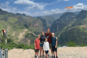
Ha Giang Loop with Toddlers & Very Young Children: Family Jeep Guide
Facebook X Reddit Table of Contents Learn more: Ha Giang Loop Tours Most people picture the Ha Giang Loop as a motorbike

Thúy Kiều (Grace) is a travel blogger and content contributor for Loop Trails Tours Ha Giang. She holds a bachelor’s degree in Sustainable Tourism from Vietnam National University, Hanoi, and has a strong passion for exploring and promoting responsible travel experiences in Vietnam’s northern highlands.

Learn more: Ha Giang Loop Tours
Before you book anything, there’s one question that actually shapes your entire Ha Giang experience: how far are you riding each day?
It sounds simple. It isn’t.
The Ha Giang Loop covers somewhere between 300 and 350 kilometres of mountain road depending on your exact route — but distance here is almost beside the point. What matters is what those kilometres contain. Tight switchbacks. Passes that climb several hundred metres in a few kilometres of road. Viewpoints you’ll pull over at ten times before lunch. Village markets that appear from nowhere and absorb two hours of your morning. A bowl of pho at a roadside stop that turns into a conversation with a Hmong family that you’ll remember longer than any vista.
The question isn’t just “how many km?” — it’s “how many km at what pace, in what conditions, with how many days?”
This guide answers all of it.

Learn more: Quan Ba Heaven Gate
Here’s the headline summary before we break it down:
| Route | Total Distance | Recommended Days |
|---|---|---|
| Classic Loop (Ha Giang → Dong Van → Meo Vac → Ha Giang) | ~300–350 km | 3–4 days minimum |
| Extended Loop (includes Du Gia / southern section) | ~380–430 km | 4–5 days |
| Ha Giang + Cao Bang Combined | ~600–700+ km | 6–8 days |
Note: Distances vary depending on specific stops, detours, and route variations used by different guides and operators. Use these as planning estimates.
The “loop” in Ha Giang Loop isn’t a perfect circle — it’s more of a rough horseshoe. You leave Ha Giang city heading north and east, climb into the Dong Van Karst Plateau, cross through Dong Van town, drop down toward Meo Vac and the dramatic Nho Que River canyon, then swing back south and west toward the city. Some routes add a southern detour through Du Gia and the waterfalls before returning.
Three days is the minimum most operators offer. Four days is what most experienced travelers recommend. Five or more days is for people who want to breathe.

Learn more: Ma Pi Leng Pass
Three days is tight. You can do it — plenty of people do — but you’ll be moving at a pace that doesn’t leave much room for spontaneity. Here’s what the daily distances look like on the most common 3-day structure.
This is the longest day by distance, and it’s where most travelers get their first real sense of what Ha Giang roads actually are.
You leave Ha Giang city and head north through Quan Ba District, passing the famous Twin Mountains viewpoint (Núi Đôi — the “Fairy Bosom” hills) and the Quan Ba Heaven Gate pass. From there, the road continues through Yen Minh town — a low-key district capital that serves as a fuel and food stop — before climbing toward Dong Van through increasingly dramatic karst terrain.
The road conditions on this stretch vary. Parts are smooth and well-paved; others are narrow, cracked, or being actively repaired. You’ll gain and lose significant elevation multiple times.
What takes the time:
Arriving in Dong Van in the late afternoon is normal. Arriving in the dark because you spent too long at every viewpoint is also normal — so on a 3-day trip, pace yourself on Day 1.
Distance-wise, Day 2 is shorter. Time-wise, it can easily be the longest day.
The morning takes you from Dong Van to Meo Vac via Ma Pi Leng Pass — arguably the most spectacular section of the entire loop, and one of the most dramatic mountain roads in Vietnam. The pass itself is only around 20 kilometres, but it includes steep drops into the Nho Que River gorge below, multiple viewpoints, and the famous Ma Pi Leng Skywalk (check current status before visiting, as access conditions occasionally change).
After Ma Pi Leng, you drop into Meo Vac town. If timing works, the Sunday market here is one of the best ethnic minority markets in the region — Hmong, Lolo, Giay, and other groups come down from surrounding villages. Even on non-market days, Meo Vac has a grittier, more local feel than Dong Van.
From Meo Vac, the route heads back southwest toward Yen Minh for the overnight stop on a 3-day route. The road through here is less dramatic but still beautiful — rolling hills, terraced rice fields (in season), and small Hmong villages.
What takes the time:
The final day brings you back south through Bac Me District and along the Lo River valley toward Ha Giang city. This section is generally the least dramatic of the three days — which isn’t saying much, because it’s still beautiful — but it’s more about winding down than peak scenery.
Some 3-day routes bypass Yen Minh and spend Night 2 in Meo Vac, which reshuffles the Day 3 kilometres slightly but covers similar total distance.
By Day 3, you’ll have a better feel for the roads and your own riding pace, which makes the return feel faster. Most people are back in Ha Giang city by mid-afternoon to late afternoon.

Learn more: Ha Giang Loop 4 Days 3 Nights
The 4-day structure covers the same core route as 3 days but adds one extra overnight, which opens up the experience significantly.
| Day | Route | Approx. KM |
|---|---|---|
| Day 1 | Ha Giang → Quan Ba → Yen Minh | ~80–90 km |
| Day 2 | Yen Minh → Dong Van (with detours) | ~60–80 km |
| Day 3 | Dong Van → Ma Pi Leng → Meo Vac | ~45–60 km |
| Day 4 | Meo Vac → Bac Me → Ha Giang City | ~110–130 km |
Distances approximate and vary by specific stops taken.
Notice what happens to the daily kilometres: they drop, the stops increase, and the experience deepens. Day 2 becomes a full day with time for the Lung Khuy Cave detour or the Dong Van Old Quarter in the evening without rushing. Day 3 becomes entirely dedicated to Ma Pi Leng — one of the world’s great mountain roads — rather than treating it as a morning commute on the way somewhere else.
Ask almost anyone who’s done both: the 3-day loop feels rushed, and the 4-day loop feels right.
The mathematics are clear enough. At 300–350 km over 3 days, you’re averaging roughly 100+ km of mountain road per day — which sounds manageable until you’re navigating switchbacks, stopping at viewpoints, and arriving at your homestay at dusk wondering where the afternoon went. Over 4 days, that same distance becomes far more breathable.
There’s also a fatigue factor. Mountain riding is mentally and physically tiring in ways that flat road riding isn’t. Constant focus on curves, road surface variation, elevation changes, and occasional gravel or rough patches adds up. Building in slower days protects both your safety and your enjoyment.
If you’re booking with Loop Trails, all our tour formats — Easy Rider, self-drive, and jeep — are available in 3-day and 4-day versions. [→ See the full Ha Giang Loop tour options here] and compare what’s included before you decide.

Learn more: Ha Giang Cao Bang 5 Days
For travelers with more time, the loop expands considerably — and so does the quality of the experience.
The “short loop” (Quan Ba → Yen Minh → Dong Van → Meo Vac → back) is the one most people mean when they say “Ha Giang Loop.” But there’s a longer southern section that swings through Du Gia — a lush, quieter valley area with a waterfall, river swimming spots, and a different landscape register entirely from the northern karst.
Adding Du Gia typically adds one day and roughly 80–100 km to the route, usually integrated as an extension of the return leg. If you’re doing 5 days, Du Gia fits naturally.
This is also where the route gets more varied in terms of road conditions — some sections toward Du Gia are more rural and less maintained, which makes it better suited to experienced riders or guided formats.
[→ Check our motorbike rental options if you’re planning the extended southern loop]

Learn more: Ban Gioc Waterfall Guide
For travelers who want to go deep into northern Vietnam, combining Ha Giang with Cao Bang Province is one of the most extraordinary road trips in Southeast Asia.
The combined route typically runs:
Ha Giang city → (full Ha Giang Loop) → Bao Lac → Cao Bang city → Ban Gioc Waterfall → Nguom Ngao Cave → Trung Khanh → (optional: Phia Oac) → return to Hanoi or reverse
Total distance for the combined route runs somewhere in the range of 600–700+ km depending on exact itinerary and return logistics. This is a 6–8 day commitment at minimum to do it justice.
Ban Gioc Waterfall — on the Chinese border — is one of the largest waterfalls in Southeast Asia and one of the legitimate highlights of northern Vietnam. Phia Oac National Park adds altitude, cloud forest, and a completely different ecological zone. The Cao Bang Loop also passes through Pac Bo Historical Site (significant in Vietnamese revolutionary history) and the stunning Ngoc Con Valley.
[→ See our Ha Giang + Cao Bang combined tour options for full route details]
This isn’t a route for people in a hurry. But for people with a week to ten days and a taste for adventure, it’s hard to beat.

Learn more: Meo Vac Town
This is worth saying plainly, because it changes everything about how you plan:
100 km in Ha Giang is not 100 km on a flat highway.
On a good expressway, 100 km might take 60–70 minutes. On the Ha Giang Loop — with its elevation changes, switchbacks, blind corners, narrow sections, and frequent stops — 100 km can easily take 4–6 hours or more. Some sections average 20–30 km/h by necessity, not by choice.

Learn more: Ha Giang Road Conditions 2026
The Dong Van Karst Plateau sits at elevations ranging from roughly 1,000 to over 1,500 metres above sea level. The roads that climb and descend through this terrain are not engineered for speed — they’re engineered to exist at all, which in some sections is already an achievement.
Road conditions across the loop vary significantly:
After heavy rain, some sections can become slippery or partially blocked by small landslides — particularly in the rainy season (roughly May through September). Rules and conditions change, so always check with your guide or local contacts before setting out in wet weather.
A useful mental model: when planning your day, think in hours, not kilometres. A 90 km day on the Ha Giang Loop can take anywhere from 3.5 to 6+ hours of riding time depending on:
Plan your days with a generous buffer. Leaving early is smart — not because there’s a strict schedule, but because arriving before dark at your homestay, with time to settle in and eat dinner properly, makes the whole experience better.

Learn more: Ha Giang Loop Self-Drive & Motorbike Rental
The route kilometres are largely the same regardless of how you travel — but the experience of those kilometres varies significantly by format.
Self-drive gives you the most control over your daily pace. You stop when you want, for as long as you want. This is genuinely freeing, but it also puts all the navigation, mechanical responsibility, and decision-making on you.
For the daily KM, self-drive riders often cover the same distances as guided formats but may spend more time at stops or take detours that guided groups skip. Conversely, getting lost (GPS and mountain roads don’t always cooperate) can add unplanned kilometres to your day.
Best for: Experienced motorbike riders, people who want true independence, those comfortable with self-navigation in remote areas.
[→ Check what’s available on our Ha Giang motorbike rental page]

Learn more: Ha Giang Loop Easy Rider
On an Easy Rider tour, your local guide drives the motorbike and you ride pillion. The guide controls the pace and knows exactly how long each section takes, which means daily distances are managed efficiently. You’ll cover the same route kilometres but with less stress — the guide handles navigation, chooses lunch stops, and generally ensures you arrive at homestays at a sensible hour.
The guides on a good Easy Rider tour also dramatically improve the cultural experience. That roadside stop isn’t just a lunch spot — it’s a place where your guide knows the family, can translate, and opens a conversation you’d never have on your own.
Best for: Solo travelers, first-timers, people who want the riding experience without the riding responsibility, anyone who wants genuine local insight.

Learn more: Ha Giang Loop by Jeep for Families & Groups
Jeep tours cover the same core loop route but from the comfort of an off-road vehicle with a driver and guide. The daily KM are identical, but jeeps move through tight switchbacks more slowly than motorbikes — which means slightly longer travel times on technical sections, but more comfort and stability overall.
Jeep tours are also better equipped for bad weather, making them the more sensible choice if you’re traveling outside the peak dry season.
Best for: Couples, small groups, older travelers, anyone who prefers comfort over the motorbike experience, travelers in shoulder or rainy season.
[→ Browse our Ha Giang Jeep Tour options here]

Learn more: Ha Giang Loop route and itinerary
Here’s a direct breakdown to help you decide:
Choose 3 days if:
Choose 4 days if:
Choose 5+ days if:
Not sure? That’s exactly what we’re here to help with. [Drop us a message on WhatsApp] and we’ll look at your dates and suggest a route that actually fits your schedule — not just the most common one.

Learn more: Ha Giang Safety Tips
Before you finalize your itinerary, a few things worth knowing:
Start early each day. Not because the loop is a race, but because the afternoon light in Ha Giang is spectacular, and being on a viewpoint at 4pm beats being on a viewpoint at 11am. Also, mountain roads get busier and can get foggier later in the day in certain seasons.
Don’t set rigid arrival times. If you plan to arrive in Dong Van by 3pm sharp and then the Twin Mountains viewpoint absorbs your afternoon, you’ll stress unnecessarily. Build flex into your day.
Fuel up in towns. Fuel stops are less frequent than on lowland roads. Yen Minh and Dong Van are the key fuel points on the northern section. Fill up whenever you have the opportunity, especially before heading into more remote stretches.
Weather changes the maths. A wet road adds caution and time. A foggy pass requires slower speeds. In the rainy season especially, your daily km targets should be conservative. Local knowledge matters here — your guide will know when to push on and when to stop.
The loop is not a race. This bears repeating because it’s easy to get competitive about distances and destinations. The people who come back raving about Ha Giang are almost never the ones who covered the most ground — they’re the ones who stopped longest at the things that surprised them.

Learn more: Ha Giang in September & October
The classic Ha Giang Loop covers approximately 300–350 km depending on the exact route taken. Extended versions that include Du Gia or additional detours run to around 380–430 km. Adding a Cao Bang extension brings the total to 600 km or more.
On a 3-day loop, daily distances average roughly 90–130 km. On a 4-day loop, daily distances drop to around 60–110 km, allowing more time at stops. The terrain means these distances take significantly longer than flat-road equivalents.
It’s the minimum, not the ideal. Three days is feasible for experienced riders who don’t mind a faster pace, but most travelers who’ve done both formats prefer 4 days. You’ll see everything in 3 days, but you’ll enjoy it more in 4.
Expect 4–6 hours of riding time per day, not including stops. On longer days (particularly Day 1 on a 3-day tour), you may be on the road for 6–7 hours total including all stops. Always plan to arrive at your homestay before dark.
Dong Van is approximately 150 km from Ha Giang city by road, but the journey typically takes 5–7 hours depending on stops and road conditions. The route goes through Quan Ba and Yen Minh.
The Ma Pi Leng Pass road section between Dong Van and Meo Vac is approximately 20 km, but this stretch takes at least 45–90 minutes to navigate properly — and that’s without extended stops at viewpoints. Don’t rush it.
On a 4-day itinerary, the Dong Van to Ma Pi Leng to Meo Vac section (Day 3) is typically the shortest in kilometres — around 45–60 km — but it’s the most intense in terms of scenery and road character. “Easy” is relative here.
Meo Vac is roughly 23–25 km from Dong Van by road — but that stretch contains Ma Pi Leng Pass, so it’s one of the most time-consuming sections of the entire loop. Budget at least 1.5–2 hours.
Technically possible on a motorbike if you skip most stops and push hard — but it’s not recommended by anyone who’s actually done it. You’ll arrive exhausted, miss everything worth seeing, and leave wondering what the fuss was about. Three days is the real minimum; four is where the experience starts.
No. The Ha Giang Loop focuses on the Dong Van Karst Plateau in the north. The Cao Bang Loop covers different territory further east, centered around Ban Gioc Waterfall, Nguom Ngao Cave, and Phia Oac National Park. Many travelers combine both on a 7–9 day northern Vietnam road trip.
The route kilometres are essentially the same by jeep. Travel time on tighter switchback sections is slightly longer in a vehicle than on a motorbike, but jeeps handle the roads confidently and offer more comfort and stability. For groups or couples, a jeep often makes more sense than two separate motorbikes.
The distances listed in this guide cover the main loop route. Side trips — like the detour to Lung Cu Flag Tower at Vietnam’s northern tip, or the Lung Khuy Cave detour near Quan Ba — add additional kilometres. Your guide or operator will factor these into daily planning if they’re included in your itinerary.
Contact information for Loop Trails
Website: Loop Trails Official Website
Email: looptrailshostel@gmail.com
Hotline & WhatSapp:
+84862379288
+84938988593
Social Media:
Facebook: Loop Trails Tours Ha Giang
Instagram: Loop Trails Tours Ha Giang
TikTok: Loop Trails
Office Address: 48 Nguyen Du, Ha Giang 1, Tuyen Quang
Address: 48 Nguyen Du, Ha Giang 1, Tuyen Quang
Facebook X Reddit Table of Contents Learn more: Ha Giang Loop Tours Most people picture the Ha Giang Loop as a motorbike

Facebook X Reddit Table of Contents Learn more: Ha Giang Loop Tours Riding the Ha Giang Loop during Tet is one of
Facebook X Reddit Table of Contents Learn more: Ha Giang Loop Tours Dong Van sits at the far northern tip of Vietnam,