
Ha Giang Loop Camera Gear Guide: Best Equipment for Mountain Photography
Facebook X Reddit Table of Contents Learn more: Ha Giang Loop Tours The first time I rode up the road to Tham

Thúy Kiều (Grace) is a travel blogger and content contributor for Loop Trails Tours Ha Giang. She holds a bachelor’s degree in Sustainable Tourism from Vietnam National University, Hanoi, and has a strong passion for exploring and promoting responsible travel experiences in Vietnam’s northern highlands.
")
Learn more: Ha Giang Loop Tours
Most people hear “Ha Giang Loop” and picture a motorbike hugging cliff-edge roads while buckwheat flowers blur past. That image isn’t wrong — the loop is one of the great road journeys in Southeast Asia. But there’s another version of this trip that fewer travelers talk about: doing it on foot, at least in part.
The trails here aren’t manicured. There are no trail signs with distance markers, no park rangers handing out maps. What you get instead is raw mountain terrain, Hmong and Dao villages that genuinely aren’t set up for tourism, and views that reward the extra effort of getting off the road. If you’re someone who wants to slow down and actually be somewhere rather than just pass through it, trekking the Ha Giang Loop changes everything.
This guide covers the best walking routes, which trails suit which fitness levels, how to combine trekking with a loop tour, and the practical stuff nobody tells you until you’re already there.

Learn more: Ha Giang Loop 2 Days 1 Night
There’s a version of the Ha Giang Loop that takes three days, moves fast, and hits the highlights. It’s perfectly valid. Then there’s a version where you park the bike at the bottom of a valley, lace up your shoes, and walk into a village that doesn’t see many visitors.
The roads here are part of the experience — nobody disputes that. But the roads also create a layer of separation. You’re moving through landscapes at 30–40 km/h, and the villages are glimpsed from a distance. Trek into them, and that changes.
Specific reasons to add walking routes to your Ha Giang itinerary:
None of this means skipping the roads. The best approach most experienced travelers recommend is combining both: ride the major passes, park up, and walk the valley sections and village routes.

Learn more: Ha Giang Loop 3 Days 2 Nights
A note before we get into specifics: Ha Giang doesn’t have a formal trail network in the way that, say, Sapa does. Most “trails” here are paths used by local farmers and herders — they exist, they’re walkable, but they’re not always obvious on a map. For anything beyond easy village walks, going with a local guide who knows the area genuinely makes a difference, both for navigation and for the experience.
That said, here are the routes worth knowing.
Best for: First-time trekkers, those who want scenery without serious elevation gain
Du Gia is one of the more popular stops on the loop, partly because it sits right alongside the Nho Que River at a point where the landscape opens up. The village itself is a mix of Tay ethnic communities and local guesthouses, and it’s become a comfortable overnight base for trekkers.
From Du Gia, there are a few well-worn walking routes:
Approximate difficulty: Easy to moderate. Mostly flat near the river, with some gentle climbs if you venture into the hills.
Best for: Experienced hikers, those with a good head for heights, anyone who wants to say they’ve actually walked Ma Pi Leng
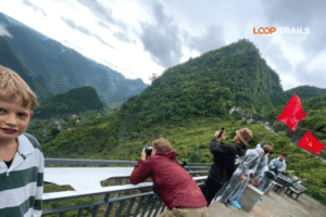
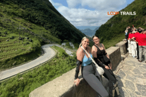
Ma Pi Leng is the most famous section of the Ha Giang Loop — a 20-kilometer mountain pass with sheer drops into the Nho Que River gorge below. Most people experience it from a motorbike seat. Walking it is a different proposition.
The classic route follows the road itself, which isn’t a dedicated hiking trail but is walkable in sections. The viewpoint above the river is about halfway along the pass and gives you the shot everyone takes — the sharp bend in the river, the cliffs, the sense of scale that photos never quite capture.
More interesting for trekkers, though, are the off-road sections that cut above the main road on older mule paths. These trails existed before the road was built and offer elevated views over the tarmac rather than along it. Access to these paths is easier with a local guide — they’re not signposted, and getting onto the wrong one in this terrain isn’t a great situation.
What to expect: The Ma Pi Leng ridge walk is not a casual stroll. You’re at altitude (the pass peaks above 1,500 meters), the terrain is rocky and sometimes loose, and in wet conditions it becomes significantly more challenging. The rewards — genuinely unobstructed views of the entire gorge system — are proportional to the effort.
Approximate difficulty: Moderate to challenging. Not a technical climb, but requires fitness, good footwear, and ideally a guide.

Learn more: Ha Giang Loop 4 Days 3 Nights
Best for: History and culture enthusiasts, those interested in ethnic minority communities, moderate hikers
Dong Van is the main town in the upper plateau region and one of the most atmospheric stops on the loop. The old quarter has French colonial-era shophouses alongside Hmong architecture, and the Sunday market draws people from villages across several districts.
From Dong Van, the road to Lung Cu (Vietnam’s northernmost point) is famous for its scenery. The flag tower at the summit sits at around 1,470 meters and is reachable by road — but there’s also a hiking trail option that cuts through the hillside above the town.
The trail up to Lung Cu is not a long one by distance, but it gains elevation steadily through rocky scrubland. At the top, you can see into China on clear days. The flag itself — a massive Vietnamese national flag — is visible from a long way off.
Around Dong Van town:
Approximate difficulty: Easy (town walks) to moderate (Lung Cu trail)
Best for: Those who want the most authentic, least-touristy trekking experience on the loop
Meo Vac sits at the far end of Ma Pi Leng and is notably less developed for tourism than Dong Van. This is partly what makes it interesting. The town itself is a market hub for H’mong, Dao, Giay, and Lo Lo communities from across the surrounding mountains, and the Sunday market here is considered one of the most genuine in northern Vietnam.
The Lung Cam valley, a few kilometers from Meo Vac, is where some of the best village trekking happens. The walking here is through agricultural land — cornfields, stone fences, low farmhouses — and into communities where interaction, even without shared language, tends to be warm and unhurried.
These routes benefit enormously from a local guide. Not because they’re dangerous, but because much of the value is in understanding what you’re seeing — which crops are which, which minority group you’re walking through, what the stone arrangements around houses mean. A good guide turns a pleasant walk into something you’ll actually remember.
Approximate difficulty: Easy to moderate. The valley floor is mostly flat; the climbs into surrounding villages vary.
Best for: Those at the start of the loop who want a quick leg-stretch hike with a big payoff
Quan Ba is the first significant stop on the Ha Giang Loop heading north from Ha Giang city. The “Fairy Bosom” twin peaks — two rounded limestone hills rising from flat valley floor — are visible from the Heaven Gate viewpoint, which most people reach by motorbike.
The short trail up to the viewpoint itself isn’t technically demanding, but the panorama it provides over the Quan Ba Valley is a legitimate wow moment and a good introduction to the scale of the landscape. Some travelers also walk from the highway down into the valley to get close to the twin peaks themselves — the path is rough but walkable in dry conditions.
Approximate difficulty: Easy. Good for all fitness levels.

Learn more: Ha Giang Cao Bang 5 Days 4 Nights
Here’s an honest summary table, because “moderate” means different things to different people:
| Trail | Distance (approx.) | Elevation Gain | Terrain | Fitness Level |
|---|---|---|---|---|
| Du Gia river trail | 5–15 km (flexible) | Low | Rocky path, riverbank | Beginner |
| Quan Ba viewpoint | 1–2 km | Low-medium | Paved + dirt track | Beginner |
| Dong Van to Lung Cu (trail) | ~10 km | Medium | Rocky scrubland | Intermediate |
| Ma Pi Leng ridge | 5–12 km (partial) | High | Rocky, exposed | Intermediate–Advanced |
| Lung Cam valley | 5–10 km | Low-medium | Farm paths, uneven | Beginner–Intermediate |
| Meo Vac hill villages | varies | Medium-high | Steep village paths | Intermediate |
Note: distances and terrain can change seasonally — trails that are easy in October can be slippery and hazardous in July. Always check conditions before setting out.

Learn more: Ha Giang Cao Bang Ba Be Lake 6 Days 5 Nights
Timing matters more for trekkers than it does for motorbike riders. Rain doesn’t just affect comfort — it affects trail safety.
October–November (Peak season for a reason) Buckwheat flowers bloom across the plateau, turning hillsides pink and white. Temperatures are cool and manageable. The dry spell after the monsoon means trails are in their best condition. This is the most popular window and for good reason, though guesthouses and tours do fill up.
March–April (Plum and peach blossom season) Less crowded than autumn. The fruit blossoms on the plateau are genuinely beautiful. Mornings can be cold and foggy, which creates atmospheric conditions for photography. Trail surfaces are generally good.
December–February Cold, sometimes very cold at altitude. Fog is frequent and can completely obscure views. Trails are passable but the experience is less comfortable. For hikers who don’t mind the cold and want fewer crowds, this window works.
May–September (Monsoon season) Some of the most dramatic landscapes — thunderstorms over the plateau, waterfalls running full, brilliant green rice terraces. But: landslides are a real risk on mountain trails, river trails can flood quickly, and some routes become impassable. If you trek during this period, stick to well-established routes, go with a local guide, and be prepared to turn back.
The short version: If you’re choosing for trekking specifically, aim for October–November or March–April.
")
Learn more: Ha Giang Motorbike Rental
This is the question most people don’t think to ask until they’re already planning: can you do the loop and trek, without it becoming a rushed mess?
Yes — but it requires a bit of intentional planning.
The standard Ha Giang Loop covers roughly 350 km in total and is typically done in 3–4 days at a brisk pace. To add meaningful trekking, you’re looking at a minimum of 4–5 days, ideally 5–6.
The most practical approach:
If you’re considering a guided option, Loop Trails runs Ha Giang Loop tours (Easy Rider, Self-Drive, and Jeep formats) with flexible itineraries that can accommodate trekking stops. It’s worth asking about this directly when you book — most guides on the loop have favorite walking routes they’re genuinely happy to include.
→ [See Ha Giang Loop Tour options here] — check the itinerary details and reach out if you want a custom trekking day added.

Learn more: Ha Giang Loop by Jeep for Families & Groups
Different travelers need different setups. Here’s a quick breakdown:
You want to trek but aren’t confident driving in the mountains: → Easy Rider tour with a local guide is ideal. Your guide handles navigation, language, and knows which trails are currently passable. You can spend an entire day trekking while they sort the logistics.
You’re an experienced rider who wants flexibility: → Self-drive motorbike rental gives you freedom to park wherever the trail looks interesting and go on foot. This works best if you’ve done some research in advance (or have this guide saved offline).
You’re traveling with a group, some of whom aren’t keen on motorbikes: → Jeep tour with a trekking add-on. Non-riders stay comfortable in the vehicle, everyone gets out for the walking sections that actually warrant it.
You want a focused multi-day trekking experience without the motorbike element: → Ha Giang is less set up for pure trekking itineraries than Sapa or Pu Luong, but it’s possible with the right local guide. Contact us directly — we can connect you with a specialist.
→ Not sure which format works for your group? Send a WhatsApp message and we’ll help you figure it out without any sales pressure.

Learn more: Ha Giang Packing list
This isn’t a Himalayan expedition, but it’s also not a walk in a city park. Pack accordingly.
Footwear (the most important thing) Trail runners or lightweight hiking boots with ankle support. The rocky limestone terrain is uneven and sometimes slippery. Do not attempt mountain trails in sandals or flat sneakers.
Clothing
Daypack essentials
What you can leave behind Heavy camera gear, unless you specifically want it. A phone camera performs well in the Ha Giang light conditions, and the weight difference matters on a full day of hiking.
")
Learn more: Ha Giang Loop Insurance
The permit situation Foreign visitors need a travel permit to enter Ha Giang province — specifically, to access the areas north of Ha Giang city along the loop route. This is typically arranged at the Ha Giang Police Department or through your accommodation or tour operator. Rules and processes around this can change, so check current requirements before your trip rather than relying on any single source (including this article).
Trail safety basics
Local etiquette on village trails
About local guides Hiring a local guide for mountain trails isn’t just a safety measure — it’s economically meaningful for communities that have limited income streams. A guide who grew up in a village near Meo Vac isn’t just navigation insurance; they’re the reason a walk becomes an actual experience.

Learn more: Ha Giang Loop Mistake to Avoid
Underestimating the altitude The Dong Van Karst Plateau sits mostly between 1,000 and 1,600 meters. That’s not Himalayan altitude, but it’s enough to affect energy levels, particularly combined with physical exertion. Don’t expect to hike all day on the same energy budget you’d have at sea level.
Treating it like a trail network when it isn’t There’s no ranger station, no official trail map, no distance markers. If you venture off obvious paths without local knowledge, you will get lost. This isn’t a reason not to hike — it’s a reason to either hire a guide or stick to routes you’ve researched properly.
Scheduling too many activities per day A common trip-planning mistake: ride 80 km of mountain roads in the morning, hike for three hours in the afternoon, and wonder why you’re exhausted by day two. Build actual rest into your itinerary. The loop isn’t a race.
Not checking road/trail conditions in advance Landslides are a genuine seasonal reality. Roads and trails that were fine last month may be blocked or washed out. Check with your guesthouse or tour operator the night before any planned trekking day.
Wearing the wrong shoes Mentioned in the packing section, worth repeating: this mistake accounts for a huge proportion of avoidable incidents on mountain trails. If you only pack one thing specifically for trekking, make it proper footwear.
Skipping the cultural context The ethnic minority communities in this region — H’mong, Dao, Lo Lo, Tay, Nung, Giay — have distinct histories, languages, and traditions. Trekking through their villages without any awareness of this is a missed opportunity. Even 30 minutes reading about the communities before your trip transforms what you see.
")
Learn more: Ha Giang Road Conditions 2026
The Ha Giang Loop has a way of surprising people who think they already know what it’s going to be. The roads are as dramatic as advertised. But the walks — down into the gorge, through the cornfields in October, up to a village above the morning fog — are the parts that tend to stay with people longest.
If you’ve been on the fence about adding trekking to your Ha Giang plans, add it. Even one full day on foot changes the texture of the whole trip.
Ready to plan? Loop Trails can build this into your itinerary — whether that’s a guided Easy Rider tour with trekking stops, a self-drive setup with recommended trail days, or a jeep option for groups of mixed fitness. [Browse Ha Giang Loop tours here] or reach out directly on WhatsApp to talk through what works for your group.
Not for the easier routes like Du Gia valley trails or the Quan Ba viewpoint walk. The more challenging options around Ma Pi Leng and Meo Vac hill villages are better suited to people with some trekking experience. Assess each route individually — the difficulty table in this guide is a starting point.
Technically yes, but the distances between major stops aren’t really practical for full-day walking. Most travelers combine motorbike transport for the long road sections with walking for specific trail days. A small number of very committed trekkers have done extended multi-day routes, but this requires serious advance planning and local guide support.
Easy village walks near major stops are generally fine alone in good weather. Mountain trails, particularly around Ma Pi Leng and in the hills above Meo Vac, are better with a guide — both for navigation and safety. Solo trekking in remote areas is inadvisable regardless of experience level.
The Du Gia river trail is the most accessible combination of scenery and walkability, and it fits easily into a standard loop itinerary. Even a two-hour walk from Du Gia guesthouse along the Nho Que riverbank gives a meaningful on-foot experience.
The general Ha Giang loop permit covers most of the areas discussed in this guide. Specific rules can change — confirm current requirements with your tour operator or guesthouse before your trip.
Yes, through guesthouses, tour operators, and local agencies. Quality varies considerably. If trekking is a priority, it’s worth arranging this through a reputable operator rather than ad-hoc at the roadside. Loop Trails can connect you with experienced local guides as part of a tour package.
October–November is widely considered the best trekking window. Temperatures are cool (roughly 15–25°C during the day, cooler at night and at altitude), skies are often clear, and the buckwheat flower bloom adds significant visual appeal. Trail conditions are at their best after the monsoon ends.
Yes, the Cao Bang region (including the area around Ban Gioc Waterfall and Phia Oac Mountain) has its own excellent trekking opportunities and is increasingly combined with Ha Giang into a longer northern Vietnam circuit. See our Ha Giang–Cao Bang combined tour guide for details.
For most routes, you’ll reach trailheads via motorbike (either your own rental or with an Easy Rider guide) and park up to start walking. There’s no public trail shuttle service. This is one practical reason why combining a tour with trekking days is more efficient than trying to organize trekking transport independently.
Some routes remain walkable in wet season — flat valley trails near Du Gia, for example. Mountain trails are significantly more dangerous due to slippery terrain and landslide risk. If you’re visiting in monsoon season, stick to lower-elevation routes, check conditions daily, and don’t attempt exposed ridge walks.
Ha Giang city has the main provincial hospital and is the practical reference point for medical care in the region. Dong Van and Meo Vac have smaller health stations. For anything serious, evacuation to Hanoi (around 320 km away) is the realistic scenario. This is another reason not to underestimate trail conditions or go into remote areas without preparation.
Yes. If standard tour formats don’t match your group’s interests, reach out on WhatsApp with your travel dates, group size, and priorities. Custom itineraries with specific trekking days can be arranged.
Contact information for Loop Trails
Website: Loop Trails Official Website
Email: looptrailshostel@gmail.com
Hotline & WhatSapp:
+84862379288
+84938988593
Social Media:
Facebook: Loop Trails Tours Ha Giang
Instagram: Loop Trails Tours Ha Giang
TikTok: Loop Trails
Office Address: 48 Nguyen Du, Ha Giang 1, Tuyen Quang
Address: 48 Nguyen Du, Ha Giang 1, Tuyen Quang
Facebook X Reddit Table of Contents Learn more: Ha Giang Loop Tours The first time I rode up the road to Tham
Facebook X Reddit Table of Contents Learn more: Ha Giang Loop Tours The Ha Giang Loop sits roughly 1,700 kilometers north of

Facebook X Reddit Table of Contents Learn more: Ha Giang Loop Tours The first time I slept in a Tay stilt house