
Cao Bang to Ban Gioc Waterfall: The Full Travel Guide
Facebook X Reddit Table of Contents Learn more: Ha Giang Loop Tours There’s a waterfall on the northern edge of Vietnam that

Thúy Kiều (Grace) is a travel blogger and content contributor for Loop Trails Tours Ha Giang. She holds a bachelor’s degree in Sustainable Tourism from Vietnam National University, Hanoi, and has a strong passion for exploring and promoting responsible travel experiences in Vietnam’s northern highlands.

Learn more: Ha Giang Loop Tours
Most travelers heading north from Hanoi already know about Ha Giang. The Ma Pi Leng Pass shots are all over Instagram. The Ha Giang Loop has a reputation that precedes it. But Cao Bang? It sits just to the east, shares the same dramatic karst geology, and gets a fraction of the foot traffic. That’s the entire appeal.
This guide is for travelers who want to go beyond the familiar and actually explore Northeast Vietnam properly. Whether you’re coming from Hanoi, connecting from Ha Giang, or planning a combined loop through both provinces, here’s everything you need to plan a real trip to Cao Bang.

Learn more: Ha Giang Loop 2 Days 1 Night
Cao Bang Province is part of the UNESCO Non Nuoc Cao Bang Geopark, one of only a handful of UNESCO Global Geoparks in Southeast Asia. That designation isn’t just administrative: it means the landscape here has genuine geological significance, with karst formations, ancient caves, and river systems that developed over hundreds of millions of years.
What you get as a traveler is one of Vietnam’s most dramatic and least-crowded provinces. The roads wind through limestone peaks. Villages appear suddenly between mountain folds. The Ban Gioc Waterfall, on the border with China, is the largest waterfall in Southeast Asia shared between two countries, and on a quiet morning in October you might have it almost to yourself.
Cao Bang also has serious cultural depth. It’s home to the Tay, Nung, Dao, and H’mong ethnic groups, and the landscapes around places like Trung Khanh and Bao Lam carry a different texture than the more-visited parts of northern Vietnam. For backpackers, couples on adventure trips, and anyone who’s already done the “standard” northern Vietnam circuit, Cao Bang is the natural next chapter.
")
Learn more: Ha Giang Loop 3 Days 2 Nights
Cao Bang is a province in the far northeast of Vietnam, bordering Guangxi Province in China to the north. The provincial capital, Cao Bang City, sits roughly 270 km from Hanoi by road, and around 150 km from Ha Giang City.
The most common route from Hanoi goes via Highway 3 through Thai Nguyen and Bac Kan. On a good day with your own transport, expect around 5 to 6 hours of driving. By sleeper bus, several operators run overnight services from Hanoi to Cao Bang City, which is a practical choice if you want to save daytime hours. Check current schedules at My Dinh Bus Station or Gia Lam, as timetables change seasonally.
If you’re renting a motorbike in Hanoi and riding up independently, the highway stretch to Bac Kan is straightforward and flat. Things get more interesting (and more technical) once you pass Thai Nguyen and start climbing into the karst zone. This is not a beginner ride from scratch: the approach roads require some comfort with mountain riding before the real mountain roads even begin.
This is the route that serious northern Vietnam travelers take, and it’s the one that makes the most logistical sense if you’re planning to combine both provinces. The road between Ha Giang and Cao Bang runs roughly 200 km depending on the specific route you take, passing through areas like Bao Lam, Bao Lac, and the Phia Oac mountain range.
This leg alone is worth a dedicated travel day. The road through Bao Lac and into Cao Bang Province passes through some of the most isolated terrain in northern Vietnam. If you’re on a Loop Trails combined tour, this section is included in the itinerary and your guide will know exactly which roads are worth the detour.
If you’re planning to combine Ha Giang and Cao Bang into one trip, check out our [Ha Giang + Cao Bang Combined Tour] page for current itinerary options and group departure dates.

Learn more: Ha Giang Loop 4 Days 3 Nights
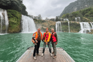
Ban Gioc is the headline attraction, and it earns the attention. The waterfall drops in three tiers into the Quay Son River, which marks the Vietnam–China border. The falls are widest during the rainy season (roughly July to October), when the water volume is at its peak and the mist carries for a hundred meters.
Getting there from Cao Bang City takes about 2.5 to 3 hours by motorbike, depending on the road you take and how many stops you make. The road through Trung Khanh is the standard route. The final approach has a small entrance fee, and you can hire a bamboo raft to paddle out onto the river for a closer look at the falls (costs check at the gate, as prices can be updated).
A few things to know: mornings are better than afternoons for light and for avoiding tour group traffic. The Chinese side of the falls has developed significantly in recent years and is visible from the Vietnamese bank. The Vietnamese side remains much quieter and more natural in feel.

Learn more: Ha Giang Cao Bang 5 Days 4 Nights
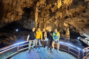
About 3 km from Ban Gioc, Nguom Ngao is a limestone cave system that has been partially developed for visitors. “Nguom Ngao” translates roughly to “tiger cave” in Tay. The interior has some genuinely impressive stalactite and stalagmite formations, and the cave runs for several kilometers in total, though only a portion is open to the public.
It pairs naturally with a Ban Gioc visit since they’re close together. Wear shoes with grip: cave floors are usually wet and uneven. Guided entry is required, and local guides are available at the entrance.
Phia Oac is one of the most underrated destinations in all of northern Vietnam. The national park sits in the western part of Cao Bang Province, and the peak of Phia Oac rises to around 1,930 meters, making it one of the highest points in the Northeast region.
The forests here are genuinely temperate: you’ll find rhododendrons, ancient trees with moss-covered trunks, and a mist that sits in the valleys most mornings. Wildlife sightings are uncommon but not impossible, including various bird species that make Phia Oac a draw for birders.
The old French silver mine at Tinh Tuc is also in this area, a remnant of the colonial era that adds a layer of history to the landscape. The roads into Phia Oac can be rough and are better suited to motorbikes or jeeps than standard cars.

Learn more: Ha Giang Cao Bang Ba Be Lake 6 Days 5 Nights
Not every stop on a Cao Bang itinerary needs to be purely scenic. Pac Bo, near the town of Ha Quang close to the Chinese border, is where Ho Chi Minh returned to Vietnam in 1941 after years in exile. The site includes the cave where he lived, the Lenin Stream (named by Ho Chi Minh himself), and a small museum.
For travelers interested in Vietnamese history, this is a genuinely meaningful site. For those less engaged with the historical angle, it’s still a pleasant half-day in a forested valley near the border. It works well as a stop on the route north toward Ban Gioc.
Thang Hen is a cluster of connected lakes in the karst plateau north of Cao Bang City, at altitude. The lakes appear and disappear with the seasons, making the landscape shift depending on when you visit. During dry season, some lakes shrink considerably; after heavy rain, they fill and spread.
The drive up to Thang Hen is steep and scenic, and the views from the plateau across the karst peaks are excellent. The Truc Lam Phuc Linh Pagoda nearby makes for a calm stop, particularly in the early morning when the mist is still sitting over the mountains.

Learn more: Explore just the Cao Bang Loop
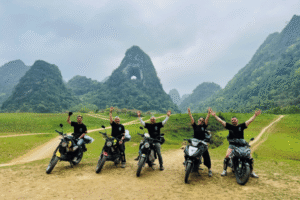
The Cao Bang Loop doesn’t have one fixed definition. In practical terms, it refers to a motorbike circuit that takes in the main highlights of Cao Bang Province, typically departing from Cao Bang City and making a loop through Trung Khanh (Ban Gioc), Phia Oac, Bao Lam, and back. Some versions of the loop extend into Ha Giang Province, connecting the two circuits into a bigger combined route.
A typical 3-day Cao Bang Loop covers:
This is a rough framework. Actual daily distances and overnight stops vary based on the tour operator, road conditions, and the size of your group. If you’re connecting from Ha Giang, add extra days accordingly.
The roads in Cao Bang are a mixed bag, and that’s part of the appeal.
The main highways (QL3, QL34) are paved and generally in reasonable condition, though maintenance quality varies. The smaller mountain roads, particularly into Phia Oac and through the Bao Lam area, can be rough, steep, and narrow. After heavy rain, mud and small landslides are possible on these sections.
For self-drive riders: you need genuine mountain riding experience. This is not a route for someone who learned to ride a week ago. Hairpin turns, wet roads, steep descents, and occasional road surface surprises are all part of the package.
For travelers who want to experience the landscape without the technical riding demands, guided options are the smarter choice.

Learn more: Ha Giang Motorbike tour
This is the question worth taking seriously before you book anything.
Self-drive is the right choice if you have confident mountain riding experience (not just city riding), you’re comfortable with navigation in areas with limited phone signal, and you genuinely want the freedom to set your own pace and choose your own stops.
Easy Rider or guided tour makes more sense if you’re new to northern Vietnam roads, you want someone who knows the local roads, villages, and can translate when needed, or if you’re traveling with a partner who doesn’t ride and will be a passenger.
Jeep tour is an option for those who want the scenery without being on a motorbike at all, and particularly useful for mixed groups where some riders and some non-riders are traveling together.
Loop Trails runs guided tours of the Cao Bang Loop with experienced local guides, small group sizes, and fixed departures. See the [Cao Bang Loop Tour] page for current dates and what’s included.

Learn more: Ha Giang Cao Bang Tour
Cao Bang has four distinct seasons, and each one changes the experience significantly.
September to November is generally considered the best window. The rice terraces around the karst valleys are at their most photogenic during harvest (late September to October). Waterfall levels are still high after the summer rains. Temperatures are comfortable, typically 18 to 25°C in the valleys. This is the peak season for a reason.
December to February brings cold temperatures, especially at altitude. Phia Oac and the higher passes can drop to near freezing. Some mornings bring fog and cloud cover that can make riding conditions difficult. That said, the off-season quiet is real: you’ll see far fewer tourists, and the landscape has a stark, atmospheric quality in winter light. Pack layers if you’re going in this period.
March to May is a good secondary window. Temperatures climb, the landscape greens up, and occasional flowering (including the Ban Gioc area’s yellow mustard flowers in some years) makes for striking photography. Rain starts to pick up from May onward.
June to August is the rainy season, and it’s the one window most guides suggest avoiding for motorbike travel. Landslides are more common, roads can become muddy or partially blocked, and the heat and humidity in the valleys is intense. If this is your only available window, it can still work, but go with a guided option and be flexible with your schedule.

Learn more: Ha Giang Loop by Jeep for Families & Groups
The honest answer: 4 to 5 days minimum if you’re coming from Hanoi and only doing Cao Bang. 6 to 8 days if you want to combine it properly with Ha Giang.
Here’s a practical breakdown:
| Itinerary | Days | Best For |
|---|---|---|
| Cao Bang highlights only (Ban Gioc + Nguom Ngao + Phia Oac) | 3–4 days | Short trip from Hanoi |
| Full Cao Bang Loop | 4–5 days | Motorbike / tour travelers |
| Ha Giang + Cao Bang Combined | 7–10 days | Serious northern Vietnam trip |
Trying to rush Cao Bang in 2 days from Hanoi means you’ll spend most of your time on the road and very little of it actually seeing things. If the schedule is tight, it’s better to cut a destination than to sprint through all of them.

Learn more: Ha Giang Food guide
Cao Bang City is the practical base. The city has a range of guesthouses and small hotels, most of them clustered around the Bang Giang River area. It’s a quiet provincial city by Vietnamese standards, nothing glamorous, but functional and with decent food options.
Near Ban Gioc: There are homestays and small guesthouses in the Trung Khanh area and directly near the waterfall. Staying near Ban Gioc lets you catch the falls in early morning light, which is worth the logistics.
Phia Oac area: Options here are very limited. Most travelers either stay in Tinh Tuc town or push through to Cao Bang City. If you’re on a guided tour, your operator will handle overnight arrangements.
General advice: book accommodation in advance during October and November. This is genuinely the peak season and the better places fill up. Outside of that window, same-day booking is usually fine.
")
Learn more: Phia Thap Insense Village
Giving exact prices here is tricky because costs change, and we’d rather give you useful ranges than numbers that might be outdated by the time you read this. Here’s a rough framework:
Getting there:
Accommodation:
Food:
Entrance fees:
Tour cost:
For a 4-day independent trip on a tight budget, plan for roughly $40–$70 USD per day covering accommodation, food, petrol, and entrance fees. Guided tours have all-in pricing that simplifies the calculation.

Learn more: Ha Giang Loop Easy Rider
If you’re trying to figure out how to structure your Cao Bang trip, here’s a straight read on which format works for which type of traveler:
You should book a guided Easy Rider or Jeep tour if:
You should consider self-drive if:
You should consider the Ha Giang + Cao Bang combined tour if:
Not sure which fits your trip? Send us a message on WhatsApp and we’ll help you figure out the right option. No commitment required, just honest advice.
")
Learn more: Ha Giang Safety Tips
Documents and permits: Regulations around the China border area can be specific. Some areas near the Vietnamese-Chinese border require visitors to stay on designated routes or check in at local authorities. Rules can and do change: check current requirements before you go, and if you’re on a guided tour, your operator should handle this briefing.
Phone signal and navigation: Signal is inconsistent in the mountains. Download offline maps (Maps.me or Google Maps offline) before leaving Cao Bang City. Viettel has the best rural coverage of Vietnamese SIM providers, though even that drops out in certain valleys.
Riding gear: Bring a proper helmet (not the thin shell ones). Gloves and a jacket matter more on mountain roads than they do in the city, especially in cooler months. If you’re on a guided tour, ask your operator what gear is provided and what you should bring.
Weather preparation: Check the forecast before you ride, especially for the Phia Oac section. Cloud cover can drop visibility quickly. Pack a lightweight rain layer regardless of the season.
Cash: ATMs in Cao Bang City work fine. In rural areas and near Ban Gioc, cash is essential. There are no card machines at the waterfall entrance or in most guesthouses outside the city. Take out enough before you leave town.
Scams and common mistakes: One common situation: unofficial “guides” offering tours at the Ban Gioc entrance area. Some are genuine, some will add charges or take you somewhere you didn’t agree to. If you haven’t pre-booked a tour, use the official ticket counter and confirmed services at the entrance. Don’t hand over money before confirming exactly what you’re getting.
Another one worth knowing: motorbike rental in smaller towns sometimes means poorly maintained bikes. If you’re renting locally rather than bringing a bike from Ha Giang or Hanoi, check brakes, tyres, and chain condition before you ride.

Learn more: Ha Giang Loop for Seniors
Yes, and especially so if you’ve already done Ha Giang. Cao Bang gets far fewer tourists, has the largest waterfall in the region (Ban Gioc), and the Phia Oac area has landscapes you won’t find anywhere else in Vietnam. For travelers willing to go a bit further northeast, it consistently over-delivers.
The most common routes are by bus (overnight sleeper from My Dinh or Gia Lam bus stations) or by motorbike along Highway 3 through Thai Nguyen and Bac Kan. The drive takes 5 to 6 hours depending on conditions and your pace.
Yes, and it works very well. The road connecting the two provinces runs through Bao Lac and Bao Lam, and it’s one of the more scenic legs in northern Vietnam. A combined trip realistically needs 7 to 10 days to avoid rushing. Loop Trails offers a combined itinerary if you’d prefer guided support for the full route.
The Cao Bang Loop is a motorbike circuit through the highlights of Cao Bang Province, typically covering Ban Gioc Waterfall, Nguom Ngao Cave, Phia Oac National Park, and the scenic mountain roads in between. It’s typically done over 3 to 5 days depending on pace and itinerary.
Licensing requirements for foreign nationals in Vietnam are a real and frequently updated topic. The general rule is that an international driving permit (IDP) endorsed for motorbikes is required, but rules can change and enforcement varies by location. Check with your home country’s licensing authority and confirm current requirements before you ride. Your tour operator or rental company should also brief you on this.
September to November, when water levels are still high from the rainy season and the weather is cooler and clearer. October is particularly good for the combination of full waterfall flow and pleasant riding temperatures.
Yes, generally. Cao Bang is a quiet province with low crime. The main safety considerations are road conditions (mountain roads require attention) and border area regulations. Travel with proper gear, let someone know your route, and use offline navigation.
Roughly 2.5 to 3 hours by motorbike, depending on road conditions and stops. The route through Trung Khanh is the main option and passes through some attractive limestone valley scenery.
Ha Giang is more famous and more visited, with iconic landmarks like Ma Pi Leng Pass, Lung Cu Flag Tower, and Dong Van Old Quarter. The Ha Giang Loop has a stronger reputation as a destination in itself. Cao Bang is quieter, has a different character (more forested, less arid than the Dong Van Plateau), and offers Ban Gioc and Phia Oac as its standout highlights. Both are excellent; they complement each other rather than being interchangeable.
Yes. Jeep tours are an option for those who don’t want to ride. You can also hire local transport in Cao Bang City for day trips to Ban Gioc. That said, a lot of the best roads and viewpoints in Cao Bang are best accessed by motorbike or 4WD, so if you’re relying on taxis or buses you’ll miss some sections.
If you’re doing a full Cao Bang Loop, yes. Phia Oac is the kind of destination that rewards travelers who are willing to get off the main road. The temperate forest, the altitude views, and the old French mine make it genuinely distinctive. It’s not a quick detour though: the roads are rough and it adds half a day minimum to the itinerary.
A proper helmet if you’re riding (not a thin shell), rain jacket, warm layer for evenings and higher elevations, comfortable hiking shoes (useful for caves and forest trails), cash in Vietnamese dong, downloaded offline maps, and sun protection for the open plateau sections.
Contact information for Loop Trails
Website: Loop Trails Official Website
Email: looptrailshostel@gmail.com
Hotline & WhatSapp:
+84862379288
+84938988593
Social Media:
Facebook: Loop Trails Tours Ha Giang
Instagram: Loop Trails Tours Ha Giang
TikTok: Loop Trails
Office Address: 48 Nguyen Du, Ha Giang 1, Tuyen Quang
Address: 48 Nguyen Du, Ha Giang 1, Tuyen Quang
Facebook X Reddit Table of Contents Learn more: Ha Giang Loop Tours There’s a waterfall on the northern edge of Vietnam that
Facebook X Reddit Table of Contents Learn more: Ha Giang Loop Tours Everyone talks about Ha Giang. The hairpin bends, the turquoise
Facebook X Reddit Table of Contents Learn more: Ha Giang Loop Tours Most travelers who make it to Ha Giang come back