

Thúy Kiều (Grace) is a travel blogger and content contributor for Loop Trails Tours Ha Giang. She holds a bachelor’s degree in Sustainable Tourism from Vietnam National University, Hanoi, and has a strong passion for exploring and promoting responsible travel experiences in Vietnam’s northern highlands.

Learn more: Ha Giang Loop Tours
Every few months, someone posts in a travel forum asking whether the Ha Giang Loop roads have improved yet. The answers they get are usually a mix of recent firsthand accounts, outdated information presented as current fact, and a fair amount of optimistic guesswork.
This guide tries to be more useful than that. It’s a section-by-section breakdown of the Ha Giang Loop roads as they currently stand — what’s paved and what isn’t, where conditions get difficult, how season changes everything, and what all of this means for deciding how to do the Loop.
One honest caveat upfront: road conditions in Ha Giang change. Construction projects finish and new ones start. Landslides alter routes. Wet seasons expose problems that dry-season travelers never see. The information here reflects conditions based on the most current available reporting — but always ask locally when you arrive, because the ground truth evolves faster than any blog post can.

Learn more: Ma Pi Leng Pass
The Ha Giang Loop covers roughly 350km of mountain roads through the northern highlands and the Dong Van Karst Geopark. That number makes it sound manageable — and in terms of daily distances, it is. What the number doesn’t tell you is that mountain roads don’t behave like flat roads. Speed is lower, concentration is higher, and the same 80km section that takes 90 minutes on the highway might take three to four hours on a winding highland pass.
Road quality on the Loop is genuinely uneven. The main circuit is predominantly paved, and the overall standard has improved significantly over the past decade as government investment in highway infrastructure has reached the province. But “paved” covers a wide spectrum — from freshly laid asphalt that’s smooth and well-marked, to old tarmac that’s been patched repeatedly, cracked by frost, undercut by water, and in places barely recognizable as the surface it once was.
What you’re dealing with on a given stretch depends on several factors: how recently it was built or resurfaced, how much traffic it takes, what the drainage is like, and whether the last rainy season was kind to it. Some sections have seen substantial improvement recently. Others are waiting for work that hasn’t arrived yet.
The Loop is not a highway. It’s a network of mountain roads with genuine character — and a rider or driver who understands what they’re getting into handles it much better than one who arrives expecting sealed surfaces and regular services throughout.

Learn more: Quan Ba Heaven Gate
The road north out of Ha Giang city toward Quan Ba is one of the better-maintained sections of the Loop — it’s the main artery into the highland circuit and gets more regular attention than remote back roads. The tarmac is generally solid through this stretch, though expect the usual Vietnamese road behaviors: motorbikes pulling out unexpectedly, construction vehicles when work is ongoing, and occasional sections where the surface has broken up near drainage channels.
Fairy Gate Pass (Cổng Trời) is the first dramatic section — tight bends, elevation gain, and the first real taste of mountain driving. The road surface here is mostly good, but it’s narrow and the corners are blind. This is where you first learn to slow right down before bends, regardless of what the theoretical speed limit says.
The stretch between Quan Ba and Yen Minh opens up into a mix of plateau driving and winding valley descents. Road quality is generally reasonable on this section — paved throughout, with the worst patches typically appearing around drainage areas and older bridge approaches.
Yen Minh town itself serves as a practical resupply stop and overnight base for many riders. The roads in and around town are straightforward. The approaches have seen some improvement but can have surface irregularities after rain.

Learn more: Ha Giang Loop for Seniors
This section contains some of the most varied road surfaces on the full circuit. The overall route is paved, but several stretches — particularly through remote valley sections and on climbs approaching the Dong Van Plateau — show their age. Patched tarmac, sections of rougher surface, and some areas where road edges have eroded are all possible.
The Dong Van Plateau approach is beautiful and, for the most part, rideable without drama for competent riders. Pay attention to road condition changes — the transition between newer and older tarmac can be abrupt, and loose gravel sometimes sits on sealed surface after rain or rockfall.
Lung Cu, accessed via a side road north of Dong Van, is reachable on a paved surface but the roads in this area can be rougher than the main circuit. Worth checking current conditions locally, particularly after any significant rain.
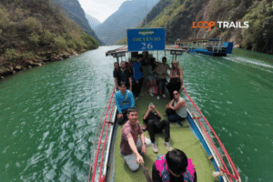
This is the section that gets the most attention — and rightfully so. Ma Pi Leng Pass is the most dramatic road on the Ha Giang Loop, carved into a cliff face above the Nho Que River with drops that don’t leave room for error.
The road surface on Ma Pi Leng itself is generally paved and in reasonable condition. The Vietnamese government has invested in this route given its significance as a tourist draw and a national heritage road. What makes it demanding isn’t primarily the surface — it’s the width (narrow enough that two vehicles passing requires care), the blind corners, and the psychological effect of the exposure. For experienced riders, it’s manageable and genuinely thrilling. For less experienced riders, it commands full concentration and slow speed.
The road between Dong Van town and the start of the pass has some rougher patches, and descending into Meo Vac from the pass involves a series of sharp hairpins. Take these slowly — the bends are tight enough that carrying too much speed into them is genuinely dangerous.

Learn more: Du Gia Waterfall
This section is often the most challenging of the main circuit for road conditions, and it’s the one where travelers most frequently encounter rough surfaces. The road between Meo Vac and Du Gia passes through remote terrain with limited infrastructure, and while the main route is paved, the condition of that paving varies considerably.
Expect: broken surface patches, sections where the road edge has degraded, water damage from drainage across the carriageway, and areas of loose debris. After sustained rain, some parts of this section can become genuinely slippery and difficult. This is also the area where landslide risk is highest following prolonged wet-season rain — not a constant hazard, but worth taking seriously.
It is one of the most beautiful sections of the Loop — deep valleys, remote villages, a sense of proper wilderness — and experienced riders handle it without major issue. Less experienced riders and anyone doing the Loop in wet season should be particularly cautious here and should not rush.
Du Gia Waterfall is a popular stop along this section. The roads immediately around Du Gia village are in acceptable condition for vehicles, though the tracks leading to the waterfall itself can be rougher.
The road back toward Ha Giang city from Du Gia follows river valleys and gradually improving infrastructure as you get closer to the provincial capital. Conditions are generally better than the Meo Vac–Du Gia stretch — this is lower elevation, more accessible terrain, and the main road toward the city gets more maintenance attention.
Some sections through the valley are genuinely good road. Others have the familiar mix of patched surface and repaired drainage crossings. Overall, this closing section is less technically demanding than what came before it and provides a gentle winding-down to the Loop.
Several side roads and alternative routes branch off the main circuit and are worth knowing about if you’re riding independently:
The back road from Meo Vac toward Bao Lac / Cao Bang: If you’re doing an extended route toward Cao Bang and Ban Gioc Waterfall, this is the direction. Road quality on this extension deteriorates further from the main circuit — beautiful, remote, but requires more riding confidence and ideally local knowledge. Ask locally before committing.
Routes around Can Cau toward Xin Man: This western detour is far less-traveled and significantly rougher than the main loop. Mostly for experienced off-road riders who specifically want the challenge.
Village access tracks: Throughout the Loop, small tracks lead off the main road to homestays and villages. These range from rough gravel to dirt trails and are best assessed in person before committing a loaded motorbike to them. Your guide (if you have one) will know which ones are passable.

Learn more: Cao Bang Loop Tours Vietnam best kept secret
The dry season is when Ha Giang road conditions are at their best and most predictable. The surfaces that were damaged by the previous wet season have usually dried out and, in many cases, been patched. Dust on unpaved sections is manageable. Drainage crossings have trickled down. Rockfall is less frequent.
This doesn’t mean the roads are without issue — old damage, poor repairs, and frost-cracked sections still exist. But the variables are fewer, and the road behaves more consistently. October through December is particularly good: recent wet-season work has dried, surfaces are stable, and you’re not dealing with frost yet.
January and February bring cold that can create new hazards — frost on exposed sections at high elevation, ice patches in very cold years on north-facing slopes, and fog that reduces visibility significantly on morning rides. These aren’t daily occurrences, but they happen. Starting later in the morning (letting frost clear) is simple and smart in these months.
March and April start to warm. Haze is common, but conditions are generally stable. The first rains of the approaching wet season can arrive in April — watch the weather.

Learn more: Ha Giang Loop Weather
Wet season changes the game. The roads that ride well in October can become genuinely treacherous after several days of sustained rain, and Ha Giang’s wet season delivers exactly that.
The specific hazards:
Slippery surfaces: Rain on old tarmac, particularly on corners and descents, reduces grip significantly. Clay patches that appear perfectly rideable when dry become skating rinks when wet. Riders who know the roads handle this by reading the surface — travelers discovering it for the first time often don’t react fast enough.
Water across the road: Mountain drainage channels cross road surfaces at regular intervals. In dry season these are trivial. In wet season they can carry significant flow — sometimes deep enough to require assessment before crossing on a motorbike.
Mud and debris: Sections that pass below unstable slopes — especially between Meo Vac and Du Gia, and on some Lung Cu approach roads — can accumulate mud and rock debris after rain. This may require riders to navigate around obstacles or wait for clearance.
Reduced visibility: Heavy rain and low cloud on passes like Ma Pi Leng and Fairy Gate significantly reduce the distance you can see ahead. Combined with wet roads, this mandates much slower speeds.
Landslides and rockfall are real hazards in Ha Giang, primarily during and immediately after heavy wet-season rain. They are not constant or inevitable — most years most sections remain open — but they do happen, and when they do, sections can close for hours to days while crews clear the road.
The most at-risk sections are those passing below steep, unstable slopes: parts of the Meo Vac–Du Gia road, some approaches to Dong Van, and sections of the Quan Ba–Yen Minh corridor that pass through active erosion zones.
What this means practically:

Learn more: Ha Giang Loop for Beginners
Ha Giang province receives ongoing infrastructure investment, and road construction is a regular feature of Loop travel. This is net positive — the roads are improving — but active construction creates its own temporary conditions to be aware of.
Active construction typically means:
As of available reporting for 2026, road improvement work has been ongoing on several sections of the Loop, with particular focus on the Yen Minh to Dong Van corridor and parts of the Meo Vac–Du Gia road. Sections that were rough in 2024 and 2025 may be improved; sections that were good may now have active construction.
This is exactly the kind of information that changes faster than a blog post. When you book with Loop Trails, we can tell you the current state of construction on specific sections based on what we’re seeing from our guides operating the routes week to week. [Reach out on WhatsApp] for the latest — this is genuinely useful intel that doesn’t exist anywhere on the internet as reliably as it does from operators on the ground.

Learn more: Ha Giang Loop Self-Drive & Motorbike Rental
The same road can be a very different experience depending on what you’re riding or sitting in. Vehicle choice matters more in Ha Giang than in most places.
A motorbike gives you the most access — you can go anywhere the road goes, including smaller tracks that a jeep can’t negotiate. The trade-off is that you feel everything the road does. Potholes, loose gravel, surface transitions — all of it comes through the handlebars.
What this demands:
The bike itself needs to be in good mechanical condition. Tyres with adequate tread are not optional on Ha Giang roads — worn tyres on wet tarmac going downhill is exactly as bad as it sounds. When renting, inspect tyres, brakes, and lights before you accept the bike.
Engine braking matters on long descents. Overusing the front brake on steep downhill sections with a loaded bike is how riders run into trouble. A manual gearbox bike (like the XR150) gives you the engine braking advantage; semi-auto bikes require more brake discipline on descents.
A trail bike or dual-sport handles rougher sections significantly better than a road-oriented semi-auto. If you’re planning to take any of the rougher back roads or are visiting in wet season, ask specifically about bike suitability when renting.

Learn more: Ha Giang Loop Easy Rider
The Easy Rider option doesn’t change the road surface — you’re on the same road on the same kind of bike. What it changes is who’s managing the variables. An experienced local guide who rides this circuit regularly knows:
This is a genuine advantage in variable conditions. If you’re uncertain about your own ability to read Ha Giang roads, an Easy Rider guide provides real-time expertise that no guide article can replicate.

Learn more: Ha Giang Jeep Tours
A jeep changes the experience of Ha Giang roads fundamentally. You’re in an enclosed, stable vehicle with significantly more mass and clearance than a motorbike. Rough patches that would require careful motorbike navigation become a mild bump. Wet road surfaces are less critical. Wind is irrelevant.
The roads of the main Ha Giang Loop circuit — including Ma Pi Leng Pass — are accessible by jeep. Some of the rougher back roads, narrow village tracks, and off-circuit routes are not. If your itinerary sticks to the main circuit, a jeep handles it without drama.
For families, older travelers, anyone with physical limitations, or anyone who simply doesn’t want the exposure of a motorbike on mountain roads, a jeep tour delivers the landscape and the experience without the riding challenge. This is a legitimate choice, not a compromise.
→ Not sure which vehicle suits your trip? [Browse our Ha Giang Loop tour options] to see how Easy Rider, jeep, and self-drive work in practice — or [message us on WhatsApp] for a straight conversation about what makes sense for your group.

Learn more: Ha Giang Loop route and itinerary
Given that conditions change, here’s a practical approach to staying informed:
Before your trip:
When you arrive in Ha Giang city:
During the Loop:

Learn more: Ha Giang Cao Bang 5 Days
Road conditions are only half the picture. The other half is the traffic and driving culture that shares the road with you.
Local vehicles: Trucks supplying highland towns, vans, local motorbikes, and occasional agricultural vehicles all use the Loop roads. Local drivers know the roads well and move with confidence — including confidence that they’ll be given room they might not technically have earned. They are not aggressive in a malicious sense; they’re simply operating in a driving culture with different rules about space and priority than most Western travelers are used to.
The practical response: give trucks and local vehicles room and don’t assume they’ll slow for you. On narrow sections, pull to the side and let large vehicles pass rather than trying to thread through.
Other travelers: The Loop attracts travelers with wildly varying riding experience. Some are accomplished bikers who’ve ridden mountain roads across Southeast Asia. Others rented a semi-auto that morning after minimal road experience and are figuring it out in real time. Both are on the same road as you. Don’t assume the rider ahead of you has assessed a section correctly — make your own assessment.
Blind corners: Standard mountain driving protocol applies here more urgently than almost anywhere. Slow before blind bends. Keep to your side. Never overtake near a corner. This isn’t optional advice; the roads are narrow enough that meeting an oncoming truck wide in a corner has serious consequences.
Night driving: As covered in our safety guide — don’t ride after dark. The roads, the lighting, the hazards, and the other vehicles all make this a category of risk without benefit. Plan your days so you arrive before sunset.
Livestock and animals: Cattle, buffalo, goats, and dogs appear on Ha Giang roads with no warning. Dogs are the most unpredictable — they often react to motorbikes by running toward them. On rural sections, maintain enough speed buffer to brake for animals in the road.

Learn more: Ha Giang Loop for Families & Groups
Road conditions are one of the most important factors in the self-drive vs. guided decision, so it’s worth mapping them directly.
| Your situation | Best option |
|---|---|
| Experienced mountain rider, dry season travel | Self-drive motorbike — full freedom, manageable roads |
| Experienced rider, wet season or uncertain conditions | Easy Rider — local knowledge navigates variable conditions |
| Beginner or limited mountain riding experience | Easy Rider — guides know the roads; you experience the Loop without the risk |
| Not a rider, any season | Jeep tour — same scenery, enclosed vehicle, road conditions matter much less |
| Small group, covering more ground, comfort priority | Jeep tour — covers the circuit efficiently without riding demands |
| Want rougher back roads / off-circuit exploration | Self-drive with a strong bike, or ask about custom Easy Rider routes |
Self-drive in wet season is the combination that most frequently leads to difficult experiences for travelers who underestimated what wet Ha Giang roads actually mean. If you’re set on self-driving, wait for dry season unless you have genuine wet-weather mountain riding experience.
Easy Rider in any season is genuinely versatile — your guide adapts to conditions, knows which sections are currently difficult, and makes the calls you’d otherwise need to make alone with less information.
Jeep is the most weather-resilient option. When the roads are at their most demanding, a jeep tour is the least affected.
→ Ready to figure out the specifics for your trip? [Browse Loop Trails Ha Giang Loop tour options] or [get in touch on WhatsApp] — we’ll give you honest current road condition intel and help you pick the right option.

Learn more: Loop Trails Tour Ha Giang website
The main circuit is predominantly paved, but road quality varies significantly by section. Some stretches are newly surfaced and smooth; others are old tarmac with patches and surface damage. The Meo Vac–Du Gia section tends to be the roughest on the main circuit. Conditions also change seasonally and with ongoing construction — check locally when you arrive.
Ma Pi Leng Pass gets the most attention for its dramatic exposure, but the road surface there is generally well-maintained. The Meo Vac to Du Gia section is usually the most challenging for actual road conditions — rougher surface, more water damage, higher landslide risk in wet season. Take it slowly and check conditions locally before setting out.
Yes. The main circuit is accessible by 4WD jeep, including Ma Pi Leng Pass. Some off-circuit back roads and narrow village tracks are not suitable for four-wheel vehicles. A jeep tour on the main loop is a fully viable and popular option, particularly for non-riders or small groups.
Significantly more challenging than dry season. Surfaces become slippery, water crosses roads, landslide risk increases on vulnerable sections, and visibility drops in rain and cloud. Self-drive in wet season is only appropriate for experienced riders with wet-weather mountain riding confidence. Guided options (Easy Rider or jeep) are more adaptable to variable conditions.
Yes — on older, damaged sections, particularly on the Meo Vac–Du Gia stretch and some back roads. The frequency and severity vary by section and season. Dry season is better; after wet season, new damage may appear on sections that were smooth before. Ride at a pace where you can respond to surface changes without sudden braking.
Local operators and guesthouse hosts will know and can advise on alternatives. Sometimes the closure is temporary (a few hours while debris is cleared); sometimes a detour is needed. Having buffer days in your schedule — not rushing the Loop on a fixed timeline — means closures are an inconvenience rather than a crisis. Guided tours are easier to adapt than self-drive in these situations.
Significantly with seasons, and continuously through construction work. A section that was rough six months ago may be newly paved; a section that was smooth last October may have taken wet-season damage. The most reliable current information comes from operators actively running the route, local guesthouse hosts, and riders who’ve just completed the circuit. Online forum posts over two or three months old should be treated as background context, not current fact.
Signal exists in towns and on sections close to inhabited areas, but it’s patchy in remote mountain sections. Download offline maps (Google Maps or Maps.me) before leaving Ha Giang city and don’t rely on real-time navigation on the road. Most sections follow a clear circuit, but offline maps are essential if you’re taking back roads or detours.
Not safely without prior mountain riding experience. The roads require the ability to manage speed on descents, handle poor surface patches without overreacting, and ride confidently on narrow roads with drop-offs. Beginners should choose Easy Rider — you’re on the same roads, experiencing the same views, with a local expert managing the riding.
October through December is the sweet spot — roads have dried from wet season, surfaces are stable, and the weather is generally clear. January and February can bring frost and fog at elevation. March and April are solid. May onwards sees increasing rain and deteriorating conditions on the more vulnerable sections.
On the main circuit, fuel is available in the main towns — Yen Minh, Dong Van, Meo Vac — and at roadside sellers in between. The sellers with jerrycans or bottles of fuel serve as informal stations in rural areas. On back roads or off-circuit routes, availability is less predictable. Know where the next reliable fuel stop is before you run low, particularly on the Meo Vac–Du Gia section.
Yes, when active. Construction vehicles on narrow roads add time and require patience. Short sections replaced by gravel bypasses while new tarmac is laid reduce speed. The net effect is usually a slower day than planned — factor in buffer time when construction is active on your route. Your guide or a local contact can tell you where active work is happening before you set out.
Contact information for Loop Trails
Website: Loop Trails Official Website
Email: looptrailshostel@gmail.com
Hotline & WhatSapp:
+84862379288
+84938988593
Social Media:
Facebook: Loop Trails Tours Ha Giang
Instagram: Loop Trails Tours Ha Giang
TikTok: Loop Trails
Office Address: 48 Nguyen Du, Ha Giang 1, Tuyen Quang
Address: 48 Nguyen Du, Ha Giang 1, Tuyen Quang

Facebook X Reddit Table of Contents They’re both in the north. They both involve dramatic limestone formations. And if you search “best

Facebook X Reddit Learn more: Ha Giang Loop Tours Table of Contents There’s a conversation that happens in every hostel common room