
Vietnam Trekking Guide: 5 Best Hikes for Every Fitness Level
Facebook X Reddit If you’re dreaming of high-altitude peaks, hidden waterfalls, and trails carved through limestone mountains, Vietnam needs to be on

Thúy Kiều (Grace) is a travel blogger and content contributor for Loop Trails Tours Ha Giang. She holds a bachelor’s degree in Sustainable Tourism from Vietnam National University, Hanoi, and has a strong passion for exploring and promoting responsible travel experiences in Vietnam’s northern highlands.

Learn more: Ha Giang Loop Tours
There’s something quietly powerful about standing at the geographic edge of a country. No border crossing, no passport stamp — just a flagpole, a wind-hammered hilltop, and the knowledge that the country you’ve been traveling through ends right here.
Lung Cu Flag Tower marks Vietnam’s northernmost point, sitting on the summit of Dragon Mountain (Núi Rồng) in Dong Van District, Ha Giang Province. It’s one of the most symbolically significant landmarks in northern Vietnam, and for most people doing the Ha Giang Loop, it’s a natural anchor point — a place you plan your route around rather than stumble across.
This guide covers everything that actually matters when visiting: how to get there, what the climb is like, which villages nearby are worth your time, when to go, and how to build it into your loop without rushing past the things that make the area genuinely interesting.

Learn more: Ha Giang Loop 2 Days 1 Night
The flag tower at Lung Cu has existed in various forms since the 18th century, though the current structure was significantly rebuilt and expanded in the early 2000s. The tower stands at the peak of Dragon Mountain, which sits at roughly 1,470 meters above sea level — the exact elevation varies slightly depending on your source, but the “northernmost point” designation is official and consistent.
The Vietnamese flag flying at the top is enormous — deliberately so. It’s meant to be visible from a distance, a statement of sovereignty at a point where Vietnam, China, and the region’s complex border history converge. The flag measures approximately 54 square meters, representing Vietnam’s 54 ethnic groups. That’s the kind of detail that sounds like a tourism-board talking point until you actually stand at the top and watch the thing thrash in the wind. Then it lands differently.
Getting to the tower requires climbing a staircase of several hundred steps carved into the hillside — more on that shortly. The site is officially maintained, has an entrance fee (verify the current amount on arrival), and is generally accessible year-round, though fog and rain can significantly affect the experience in certain seasons.

Learn more: Ha Giang Loop 3 Days 2 Nights
The Ha Giang Loop has no shortage of dramatic viewpoints. Ma Pi Leng Pass is more technically impressive. The Nho Que River seen from above is more photogenic in a pure landscape sense. Dong Van’s old quarter is more atmospheric after dark.
Lung Cu offers something those places don’t: context.
Standing at Vietnam’s northernmost point, looking north toward China and south over the karst plateau that you’ve been riding through, the scale of what you’re doing on the loop finally registers. You’re at the top — literally. Every road you’ve taken to get here, every pass and valley, was leading somewhere with actual geographic and historical weight.
The Lo Lo Chai village sitting in the valley directly below the tower adds to this. It’s one of the best-preserved ethnic minority villages in the entire Ha Giang region, and the visual contrast between the ancient stilt houses below and the flag tower above is one of those images that stays with you.
It’s also worth saying: Lung Cu is emotional for Vietnamese travelers in a way that foreign visitors sometimes don’t immediately clock. If you’re visiting alongside Vietnamese tourists — which you likely will be, especially on weekends and holidays — their response to the place is part of the experience. Respect that.

Learn more: Ha Giang Loop 4 Days 3 Nights
Most riders approaching from the south — starting in Ha Giang city and heading northeast — will pass through Yen Minh before continuing northwest toward Dong Van. From Dong Van, Lung Cu is approximately 24km north. The road from Dong Van to Lung Cu is among the more manageable sections of the loop: paved, clearly signed, and with scenery that keeps building as you approach.
The full Ha Giang to Lung Cu route typically takes the better part of a day when done properly — not because of distance, but because the roads between Yen Minh and Dong Van include enough viewpoints and villages that anyone with a functioning pair of eyes will stop repeatedly.
Dong Van is the natural base for visiting Lung Cu. The 24km road north from Dong Van winds through the plateau, past scattered minority villages and increasingly dramatic karst formations, before the final climb toward Dragon Mountain. This section of road is one of the most reliably good on the entire loop — relatively smooth, scenic, and not as traffic-heavy as the Yen Minh–Dong Van stretch.
Many riders stay overnight in Dong Van, visit Lung Cu as a morning ride, then continue south toward Meo Vac and Ma Pi Leng Pass the following day. That rhythm works well.
Ha Giang’s roads are genuinely beautiful and genuinely unpredictable. Conditions between Yen Minh and Dong Van involve mountain switchbacks with varying surface quality. The Dong Van to Lung Cu stretch is generally better maintained, but:
Road conditions change seasonally and after weather events — always check with local guesthouses or your tour guide the morning of your ride. No website can give you real-time road information.
Thinking about riding this route yourself? Take a look at Loop Trails’ motorbike rental options in Ha Giang — we can advise on the right bike for your experience level before you commit.

Learn more: Ha Giang Cao Bang 5 Days 4 Nights
From the parking area at the base, you climb a stone staircase to reach the tower. The number of steps varies slightly in different reports — somewhere in the range of 360–400 steps — set into the hillside with dragon sculptures lining the railings. It’s not a casual stroll, particularly in heat or if you’ve been riding all day, but it’s entirely doable for anyone in reasonable health. Allow 15–20 minutes up, similar down.
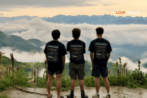
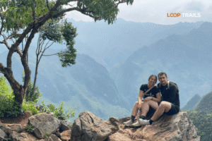
The tower itself is a multi-tiered structure you can enter. Climbing to the observation deck gives you a 360-degree view: karst mountains in every direction, the valley settlements below, the Chinese border territory visible to the north. On a clear day, the view is genuinely arresting. On a foggy day, you see maybe 50 meters in any direction and the tower disappears into white — which has its own atmosphere, though it’s not what you came for.
The flag at the top is the main event. In wind, which is most of the time at this altitude, it’s loud, dramatic, and completely photogenic. In still air, it hangs differently. Either way, you’re not leaving without photographing it.
There’s a small museum inside the tower base covering the history of the border region, the tower’s construction, and information about the ethnic groups in the area. Worth 10–15 minutes if you read slowly.
Looking down from the summit, you’ll see two villages sitting in the valley directly below: Lo Lo Chai and Pa Lo. They’re not just backdrop — they’re destinations in their own right, and the short ride or walk down to them is one of the better decisions you can make at Lung Cu.
Lo Lo Chai in particular is the kind of village that travel writing has been desperately trying to describe without overselling for years. It’s old. The wooden and stone houses have been here for generations. The Lo Lo ethnic minority people who live there have a distinct culture, dress, and calendar. There are a handful of homestays, which means you can actually sleep in the village if you want to extend your time.

Learn more: Ha Giang Cao Bang Ba Be Lake 6 Days 5 Nights
Lo Lo Chai is roughly 1–2km from the base of Lung Cu, easy to reach on a motorbike or on foot if you have the energy after the tower climb. The village has been recognized as a cultural heritage site, and despite that designation, it hasn’t been theme-parked. People live here. Chickens roam. The houses are a mix of traditional mud-brick structures and more recent builds, which is honest — no village is frozen in time.
The Lo Lo are one of Vietnam’s smaller ethnic minority groups, and their textile work — intricate embroidery and patchwork in strong geometric patterns — is distinctive and genuinely beautiful. If you’re buying textiles anywhere on the loop, Lo Lo Chai is one of the better places to do it from makers rather than resellers.
Spending an hour walking through the village is more interesting than most half-day “cultural experiences” elsewhere on the loop. Take your time. Ask your guide to make introductions if you have one.
Pa Lo sits further along the valley and has a slightly different character — quieter, less visited, and with views back toward Dragon Mountain that are excellent for photography in the right light. It’s worth the short detour if you have time, particularly in the early morning before the tour groups arrive at Lung Cu.
On the road between Dong Van and Lung Cu, the route passes through Sung La Valley — a wide, flat valley floor surrounded by vertical karst walls, with scattered Ha Nhi and Mong villages dotted across it. It’s one of those landscapes that makes you slow down without intending to. Stop here. Walk down to the valley floor if you can. The scale of the karst formations is more apparent at ground level than from the road above.
Sung La is also known as the filming location for parts of the Vietnamese film Chuyện của Pao — not essential knowledge, but it explains the cinematic quality of the place.

Learn more: Ha Giang in September & October
The timing question for Lung Cu is really the timing question for the Ha Giang Loop, with one specific consideration: the summit of Dragon Mountain creates its own microclimate, and fog and wind are more of a factor here than at lower points on the loop.
| Season | Months | Lung Cu Conditions |
|---|---|---|
| Buckwheat flower season | Oct–Nov | Peak crowds, stunning plateau colors, generally clear skies |
| Rice harvest | Sep–Oct | Golden terraces on the approach road, good weather window |
| Dry & cool | Nov–Mar | Clear visibility most days, cold at summit (bring layers), fewer tourists |
| Spring | Mar–May | Warming up, wildflowers on the plateau, manageable crowds |
| Rainy season | Jun–Aug | Lush green, significant fog risk, landslide risk on approach roads |
For the view specifically: clear mornings are the goal. Fog rolls in at Dragon Mountain’s altitude frequently, particularly in winter and during the rainy season. If you have flexibility, wait for a clear morning rather than riding up in fog. A guesthouse owner in Dong Van will tell you honestly whether the tower has been clear recently.
For the villages: any time the main tourist flow is lighter — early morning, weekdays outside major holidays — Lo Lo Chai feels more like itself. Weekend afternoons bring Vietnamese domestic tourists in volume, which changes the atmosphere significantly.

Learn more: Ha Giang Homestay Guide
Dong Van is the practical base for Lung Cu. It’s 24km south, has the widest selection of accommodation in the northern loop, and puts you within range of both Ma Pi Leng Pass (south) and Lung Cu (north). The Dong Van old quarter has several well-regarded guesthouses and small hotels with mountain views — book ahead during peak season (September–November).
Lo Lo Chai village has a small number of homestays, which allows you to stay inside the village itself. This is a genuinely different experience from town accommodation — simpler, quieter, and with early morning light on Dragon Mountain that’s hard to match from anywhere else. Facilities are basic. Worth it if you’re traveling for experience over comfort.
Lung Cu commune center has some accommodation options closer to the tower, but selection is limited compared to Dong Van. Good if you want to be right there and don’t need many options.
For all accommodation in this area, booking ahead during October and November is strongly recommended. Outside peak season, showing up without a reservation usually works, but calling ahead via translation apps is still smart.

Learn more: Ha Giang Motorbike Rental
Lung Cu is a fixed point on the Ha Giang Loop — every main route variant passes through or near Dong Van, which means every Loop Trails tour option reaches Lung Cu. The question is how you get there and what the experience looks like on the road.

Learn more: Ha Giang Loop Easy Rider
You’re on the back; your guide is driving. For a site with the specific cultural and historical significance of Lung Cu, a knowledgeable guide makes a significant difference. They’ll explain what you’re looking at from the tower, make introductions in Lo Lo Chai, know which homestay in the village is genuinely worth staying at, and tell you whether to push on or wait for the fog to clear.
The Easy Rider option on the Dong Van–Lung Cu stretch is particularly good because the scenery between those two points is dense enough that you want someone else managing the throttle while you look around.
Best for: First-time Ha Giang visitors, travelers who want context and local knowledge built into the experience, anyone who wants Lo Lo Chai to be more than a photo stop.

Learn more: Ha Giang Loop Self-Drive & hire a motorbike
The Dong Van to Lung Cu road is one of the more approachable sections of the loop for self-drivers — better surface quality than some sections further south, clear signage, and manageable traffic. If you’re an experienced rider who has already navigated the trickier parts of the loop, this final stretch to Lung Cu is a satisfying ride to do on your own terms.
The tradeoff: without a guide, Lo Lo Chai is a walk-through rather than an introduction. You’ll still see it and appreciate it; you’ll just get less out of it.
Best for: Experienced riders, repeat visitors to Ha Giang, travelers who prioritize freedom and have the riding confidence to handle mountain roads.

Learn more: Ha Giang Loop by Jeep for Families & Groups
The road to Lung Cu is jeep-accessible. You lose the riding experience but gain comfort, a better vantage point from a higher vehicle, and the ability to travel with people who can’t or don’t want to ride. The jeep option handles the steep road up toward Dragon Mountain without the physical demands of motorcycling.
Best for: Families, mixed groups where not everyone rides, travelers with mobility considerations, anyone who wants to see the landscape without the exertion.
Not sure which option fits your itinerary? Send us a message on WhatsApp — we put together a lot of custom routes that include Lung Cu and can help you figure out the right pacing based on your schedule.

Learn more: Ha Giang Loop Mistake to Avoid
Go early. The tower gets crowded by mid-morning, particularly on weekends and during peak season. Arriving before 8am means better photos, better light, and the summit more or less to yourself. Fog also tends to burn off in the morning, so early arrivals get better visibility.
The entrance fee is payable at the base. Verify the current amount — it’s modest, but carry cash. There’s no card reader at the ticket booth.
The steps are real exercise. Particularly if you’ve been on a motorbike for several hours, the climb will feel it. Take your time, drink water, and don’t underestimate it in heat. The descent can be slippery when wet.
Weather changes fast at this altitude. You can leave Dong Van in sunshine and arrive at the tower base in thick fog. Check sky conditions locally and, if fog is heavy, consider waiting it out at a nearby café for an hour or two before climbing.
Don’t skip Lo Lo Chai for the sake of time. A lot of riders tick Lung Cu and immediately head back south. The tower is the objective; the village is the experience. Give yourself at least 45 minutes in Lo Lo Chai after the climb.
Drone flying: Regulations around drone use near border areas in Vietnam are strict and can change. Do not assume it’s permitted — check current rules with local authorities or your tour operator before bringing one out.
Photography at the top: The flag and the view photograph beautifully, but be mindful of military presence at the site. There are occasional restrictions on what can be photographed — follow instructions from staff and signage on the day.
Packing checklist for Lung Cu day:
Ready to put the full loop together with Lung Cu as the centerpiece? Browse Loop Trails’ Ha Giang Loop tours — Easy Rider, self-drive, and jeep options available, with itineraries that build in proper time at Lung Cu and Lo Lo Chai rather than a quick photo stop.
")
Learn more: Ha Giang Loop for Couples
Lung Cu Flag Tower is located at Vietnam’s northernmost point, on Dragon Mountain (Núi Rồng) in Dong Van District, Ha Giang Province. It sits at approximately 1,470 meters above sea level near the Chinese border.
Reports vary slightly, but the staircase to the tower involves roughly 360–400 steps. Allow 15–20 minutes to climb at a steady pace. It’s manageable for most people in reasonable health, but steep enough to feel it if you’ve been riding all day.
Yes, there is an entrance fee payable at the base. The amount can change — verify the current fee on arrival and bring cash, as card payment is not available.
Approximately 24km north of Dong Van along a well-paved road through Sung La Valley. The drive typically takes 45 minutes to an hour, depending on how many stops you make
Clear weather mornings are best for the view. October–November (buckwheat flower season) and September–October (rice harvest) offer the most reliably good conditions and most photogenic surroundings. Avoid the peak rainy season if fog and landslide risk are concerns.
Technically possible but not recommended. Ha Giang to Lung Cu and back in a single day is a very long ride with little time to actually experience the area. Spending at least one night in Dong Van and visiting Lung Cu as a morning stop makes for a far better trip.
Yes Lung Cu is on the northern section of the main loop route, and virtually all Ha Giang Loop itineraries of 4 days or more include it. Shorter 3-day loops sometimes skip it to save time, but this is generally considered one of the less worthwhile shortcuts.
Lo Lo Chai village sits in the valley directly below the tower and is the main nearby village worth visiting. Pa Lo is further along the valley and quieter. Both are reachable by motorbike from the tower base.
The Dong Van to Lung Cu road is more manageable than the trickier mountain sections of the loop, but it’s still a mountain road in Ha Giang. First-time riders in the area should seriously consider an Easy Rider (guided) tour rather than self-driving.
Yes, Ha Giang and Cao Bang are geographically adjacent provinces, and combining them in an extended northern Vietnam loop is one of the better ways to see the region properly. Lung Cu fits naturally at the northern peak of that combined itinerary. Check out Loop Trails’ Ha Giang–Cao Bang combine tours for more.
Dong Van (24km south) is the main accommodation hub and has the widest selection. Lo Lo Chai village has a small number of homestays for those wanting to stay closer to the tower. Options at Lung Cu commune center itself are limited — book ahead during peak season regardless of where you stay.
Drone regulations near border areas in Vietnam are strict and subject to change. Do not assume it’s permitted — confirm current rules with local authorities or your tour operator before using any drone at or near the tower.
Contact information for Loop Trails
Website: Loop Trails Official Website
Email: looptrailshostel@gmail.com
Hotline & WhatSapp:
+84862379288
+84938988593
Social Media:
Facebook: Loop Trails Tours Ha Giang
Instagram: Loop Trails Tours Ha Giang
TikTok: Loop Trails
Office Address: 48 Nguyen Du, Ha Giang 1, Tuyen Quang
Address: 48 Nguyen Du, Ha Giang 1, Tuyen Quang
Facebook X Reddit If you’re dreaming of high-altitude peaks, hidden waterfalls, and trails carved through limestone mountains, Vietnam needs to be on

Facebook X Reddit Table of Contents Learn more: Ha Giang Loop Tours Vietnam looks manageable on a map. Then you drive it.
Facebook X Reddit Table of Contents Learn more: Ha Giang Loop Tours Most people ride Ha Giang the way you eat a