
Two UNESCO Geoparks in One Trip: Dong Van + Non Nuoc
Facebook X Reddit Table of Contents Learn more: Ha Giang Loop Tours If you’ve been dreaming about Vietnam’s limestone karst landscapes but

Thúy Kiều (Grace) is a travel blogger and content contributor for Loop Trails Tours Ha Giang. She holds a bachelor’s degree in Sustainable Tourism from Vietnam National University, Hanoi, and has a strong passion for exploring and promoting responsible travel experiences in Vietnam’s northern highlands.

Learn more: Ha Giang Loop Tours
If Day 1 of the Ha Giang Loop is the warm-up, Day 2 is where the trip announces itself. This is the day you push into the Dong Van Karst Plateau, reach the northernmost point in Vietnam at Lung Cu Flag Tower, walk through the courtyard of a H’mong king’s former palace, and end the evening in one of the most atmospheric small towns in the country.
It’s a big day. The road gets more serious, the distances feel further, and by the time you reach Dong Van’s old quarter at dusk, you’ll have a strong sense of how different this corner of Vietnam is from everywhere else you’ve been. That contrast — the scale of the mountains, the remoteness of the settlements, the mix of ethnic communities going about daily life on roads that tourists started discovering only recently — is exactly what makes Day 2 the one people remember longest.
This guide walks you through every stop, with honest notes on timing, road conditions, what’s worth your attention, and how to pace things without missing the highlights.
")
Learn more: Ha Giang Loop 2 Days 1 Night
Day 2 starts in Quan Ba and follows QL4C further north and east toward Dong Van district, with a significant detour to Lung Cu at Vietnam’s northern tip. Depending on your itinerary and pace, you’ll pass through Yen Minh town, enter the Dong Van Karst Plateau Geopark zone, push up to Lung Cu, double back to Sung La Valley for Vuong Palace, and arrive in Dong Van Old Quarter for the night.
The main stops in order:
This is a long day. Pacing matters.

Learn more: Ha Giang Loop 3 Days 2 Nights
| Detail | Info |
|---|---|
| Starting point | Quan Ba town |
| End point | Dong Van Old Quarter |
| Total distance | approximately 110 to 130 km (including Lung Cu detour) |
| Riding time (no stops) | roughly 3.5 to 4.5 hours |
| Realistic total time | 7 to 9 hours with stops |
The jump in numbers from Day 1 is real. Today covers more distance and the roads are more varied — some sections are excellent, others are narrow, winding, and shared with trucks carrying goods to border communities. The Lung Cu detour adds distance and climbing, and Vuong Palace requires a side road off the main highway.
What changes from Day 1 road-wise:
Heading out on the Loop and not sure which tour format fits your riding ability? Our [Ha Giang Loop tour page] covers all three formats easy rider, self-drive motorbike, and jeep with honest notes on who each option is best for.

Learn more: Ha Giang Loop 4 Days 3 Nights
Yen Minh sits about 45 to 50 km from Quan Ba and is the last proper town before the road dips into the Dong Van Geopark zone. It doesn’t make most traveler highlight lists and that’s fine its role on Day 2 is functional: fuel up, eat if you’re hungry, and keep moving.
That said, Yen Minh has a quiet charm if you arrive at the right time. The morning market is active with H’mong, Tay, and Lo Lo traders, and the town sits in a valley at a lower elevation than what’s ahead, so the weather is often clearer and warmer here than at Dong Van.
What to do in Yen Minh:
Don’t linger too long. The best part of the day is ahead, and Lung Cu deserves more than a rushed visit.
")
Learn more: Ha Giang Loop by Army Jeep Tours
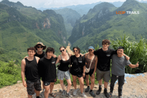
You won’t see a gate or a clear entry point when you cross into the Dong Van Karst Plateau Geopark — it announces itself through the landscape instead. The limestone formations get sharper and more dramatic, the valleys narrower, the rock faces more exposed. Villages begin to look different: stone houses instead of wood, fences made from stacked flat stones, terraces cut into impossibly steep slopes.
The Dong Van Karst Plateau was designated a UNESCO Global Geopark in 2010, one of only a handful in Southeast Asia. The designation recognises the geological significance of the area: these are some of the oldest rock formations in the region, more than 400 to 600 million years old, and the landscape holds traces of ancient sea floors, coral reefs, and tectonic activity visible in the cliff faces along the road.
The geopark covers a large area across four districts including Quan Ba, Yen Minh, Dong Van, and Meo Vac. By Day 2 of the Loop, you’ve already been inside it since yesterday — but the visual impact intensifies the further north you go.
What the geopark status means for travelers:
Take a moment somewhere in this section at a bend with a valley view, or beside a dry-stone village to appreciate the age of what you’re looking at. It’s one of those places where the scale of geological time genuinely lands if you let it.

Learn more: Ha Giang Cao Bang 5 Days 4 Nights
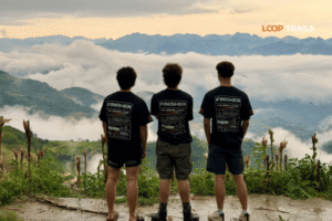
Lung Cu Flag Tower (Cột Cờ Lũng Cú) is the kind of place that earns its reputation. A 33-metre tower on the summit of Dragon Mountain (Núi Rồng) at roughly 1,700 metres above sea level, flying one of the largest Vietnamese flags you’ll see anywhere. Below it, the landscape drops into valleys on both the Vietnamese and Chinese sides of the border.
Getting here requires a detour off QL4C — the road to Lung Cu branches left (or right, depending on your direction) and climbs for several kilometres before reaching the parking area at the base. From the parking area, you climb approximately 250 stone steps to reach the tower itself. The climb takes 10 to 15 minutes at a reasonable pace and the steps are well-maintained, though exposed and windy at the top.

Lear more: Lung Cu Flag Tower
From Yen Minh or from the main QL4C heading north, follow signs to Lung Cu. The detour adds roughly 20 to 30 km round-trip to your day, but it’s non-negotiable for most travelers this is one of those landmarks that justifies the whole Loop.
A few practical notes:
The tower platform has views across the border zone you can see into Yunnan Province, China, on a clear day. Below you are H’mong villages, small reservoirs, and the patchwork of terraced fields that cover every slope that can support one.
The flag at the summit is enormous. It’s changed regularly and the size of it against the sky has a genuine impact that photos don’t fully capture. Most people spend 20 to 30 minutes at the top enough for photos, enough to absorb the geography.
One thing worth knowing: Lung Cu is close to an active border zone. Photography is generally permitted at the tower and viewpoints, but be aware of any restrictions posted rules can vary and are worth checking locally.
")
Learn more: Ha Giang Cao Bang Ba Be Lake 6 Days 5 Nights
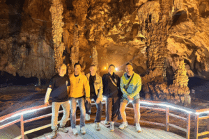
From Lung Cu, the route south and west toward Dong Van takes you through Sung La Valley, and here you’ll find Vuong Palace (Dinh Vuong, or officially Dinh Họ Vương). It sits in the valley floor surrounded by rock formations and terraced fields, which makes the approach genuinely cinematic — the palace appears suddenly as you round a corner, and it looks completely out of place in the best possible way.
Vuong Palace was built between 1898 and 1902 for Vuong Chi Sinh, the patriarch of the Vuong family — the most powerful H’mong clan in the region during the French colonial period. The Vuong family controlled the opium trade across the plateau for decades, accumulating wealth and political influence significant enough that the French largely left them to govern their own territory.
The palace was designed by Chinese architects and built by craftspeople from Yunnan, with a blend of traditional H’mong elements and southern Chinese Qing dynasty aesthetics. The result is a layered compound of courtyards, reception halls, living quarters, and a fortified outer wall — all built from stone quarried from the surrounding valley.
The family continued to live here until the 1950s. The palace is now maintained as a historical monument by local authorities.

Learn more: Hmong’s King Vuong Palace
Entry is paid (check the current fee on arrival). Inside:
Budget 45 minutes to an hour here. It’s not a quick in-and-out stop the layers of history are worth reading, and the courtyard architecture rewards a slower look.
The valley road around Vuong Palace is also worth a short wander on foot if time allows. The landscape here flat valley floor, vertical limestone walls, old stone farmhouses is among the quietest and most beautiful you’ll see on the Loop.

Learn more: Dong Van Old Quater at Night
Dong Van Old Quarter (Phố Cổ Đồng Văn) is the overnight stop for Day 2 and one of the best small towns in northern Vietnam. The old quarter is compact a few streets of stone and timber shophouses dating back to the late 19th and early 20th centuries but it punches well above its size in atmosphere.
The town sits in a small basin surrounded by limestone karst peaks on all sides. In the late afternoon, when the light softens and smoke from cooking fires drifts up, and motorbikes weave through the narrow lanes between the old houses, it feels genuinely remote in a way that most Vietnamese tourist towns don’t.
Options in Dong Van town have improved significantly over recent years as Loop tourism has grown. A few things to know:
If your tour is booked through Loop Trails, your guide will point you to reliable dinner options. If you’re self-driving, ask at your guesthouse.
Accommodation in Dong Van ranges from basic guesthouses in the old quarter to a small number of more comfortable lodge-style options on the hillsides above town. Guesthouses in the old quarter buildings give you the atmosphere; hillside options give you quieter rooms and better views.
")
Learn more: Ha Giang Cao Bang Ba Be Lake 6 Days 5 Nights
Day 2 is where transport choice starts to matter more than it did yesterday. The road is longer, the Lung Cu detour involves steep climbing, and the Sung La Valley road to Vuong Palace is a narrow single-lane in places.
Self-drive motorbike: If you handled Day 1 comfortably, Day 2 is manageable. The roads are more demanding in places particularly the Lung Cu approach and parts of the plateau but nothing technically extreme. The main challenge is pace: you need to start early and move efficiently to hit Lung Cu, Vuong Palace, and still reach Dong Van with daylight to spare. Self-drivers who enjoy flexibility will find Day 2 satisfying.
Easy rider (motorbike with local driver): Day 2 is where having a local guide earns its value most clearly. The stops are layered with history and context, and having someone who can explain the Vuong family legacy, point out H’mong village customs along the Sung La road, or navigate the Lung Cu route without hesitation makes the day substantially richer. Easy rider guides also set a realistic pace that self-drivers sometimes don’t manage without experience.
Jeep tour: The jeep covers all Day 2 stops with the same access. The road to Lung Cu and around Vuong Palace are both jeep-accessible. The elevated seating makes the landscape views through the geopark zone feel even more immersive, and the return from Lung Cu offers some long plateau views that are genuinely best experienced from a higher vantage point. Jeep is a strong option for Day 2 specifically because the distances and varied terrain play to the vehicle’s strengths.
Take a look at all our tour options: easy rider, self-drive, and jeep — on the [Ha Giang Loop tours page]. If you want to talk through which format fits your trip, send us a message on [WhatsApp] and we’ll help you figure it out.

Learn more: Ha Giang Motorbike Rental
Leave Quan Ba by 7:30 to 8:00 AM. Day 2 is the longest day of the Loop in most itineraries. If you leave late, you’ll be rushing Vuong Palace or skipping Lung Cu, and neither is a good trade.
A rough time guide (estimates only, dependent on your pace):
Total: around 7 to 8 hours with stops. Early departure is the single biggest factor in how relaxed or rushed this day feels.

Learn more: Ha Giang Loop Mistake to Avoid
Trucks and large vehicles are more present on this section than Day 1 because the road serves border communities and agricultural transport. Give them room on narrow sections.
Altitude and temperature shift. Dong Van sits higher than Quan Ba and can be noticeably cooler in the evening. If you’re arriving after sunset, have a warm layer accessible.
Timing at Lung Cu. Don’t rush the flag tower to “make time” elsewhere. It’s the highlight of Day 2 for most people. Budget it properly.
Road conditions after heavy rain. The geopark plateau roads are more susceptible to landslide debris than the QL4C sections you rode on Day 1. If there’s been significant rain in the days before you travel, ask your guide or guesthouse about the road status. Rules around closures can change — check local updates before heading out.
The Dong Van Saturday Market. If you’re arriving on a Friday night, be aware the town will be busier and louder than usual. If you want the market experience, plan for it. If you want quiet, plan around it.
")
Learn more: Cao Bang Loop 3 Days best kept secret
After two days, you’ve reached Dong Van roughly the midpoint of the classic Loop route. What’s ahead depends on your itinerary:
If you’re doing 3 days 2 nights: Day 3 heads south from Dong Van along the Ma Pi Leng Pass to Meo Vac and then loops back toward Ha Giang city via the southern route. This is the most dramatic road day of the entire Loop.
If you’re doing 4 days 3 nights: Day 3 stays around Dong Van and Meo Vac with more depth the Nho Que River boat section below Ma Pi Leng, the Meo Vac market (on Sundays), and possible side routes through Du Gia waterfall on the return. This format gives the trip breathing room and is worth the extra day if your schedule allows.
If you’re interested in extending into Cao Bang: after the Loop, a combined route continuing into Cao Bang province covers Ban Gioc Waterfall (one of the largest in Southeast Asia), Nguom Ngao Cave, and the Phia Oac mountain area. The Ha Giang and Cao Bang combined tour runs 5 days 4 nights and is the most complete northern Vietnam road trip available.
Take a look at how the full Loop itinerary maps out on our [Ha Giang Loop 3 days tour] and [Ha Giang Loop 4 days tour] pages. And if you’re considering the Cao Bang extension, the [Ha Giang and Cao Bang combined tour] page has the full day-by-day breakdown.
")
Learn more: Tu San Canyon & Nho Que River Boat Trip
The total distance for Day 2 including the Lung Cu detour is approximately 110 to 130 km. Without the Lung Cu side trip it’s shorter, but most itineraries include Lung Cu as a standard stop. Expect 7 to 9 hours total including stops.
Yes, for most travelers. It’s the northernmost accessible point in Vietnam, the views over the border landscape are unique, and the climb to the tower adds a physical element that makes arriving feel earned. If you’re extremely pressed for time on a short itinerary, it’s the one stop that could technically be skipped — but the majority of people who’ve done the Loop rate it as a highlight.
There is an entry fee at Lung Cu. The exact amount can change, so check on arrival rather than relying on a figure from a blog post. It’s a modest amount relative to the experience.
The architecture alone is worth the stop : the compound is visually striking regardless of historical context. That said, spending 15 to 20 minutes reading the information panels adds significant depth to the visit. It’s one of the few places on the Loop with a specific human story attached to the landscape around it.
If you can time your Day 2 arrival in Dong Van to coincide with the Saturday night market, it’s worth doing. Ethnic minority traders from surrounding villages gather here and it’s one of the most genuine market experiences in the north. Plan accommodation in advance if you’re coming that night — Dong Van fills up.
Local guides and guesthouse staff at main stops typically have some English. Deeper conversations about H’mong culture, family histories at sites like Vuong Palace, and local food contexts are significantly richer with a bilingual guide. If cultural depth matters to you, booking with a tour that includes an English-speaking guide is worth it.
It’s physically possible — Lung Cu is roughly 160 to 180 km from Ha Giang city — but doing it as a day trip means very long riding times and rushing the geopark. The Loop is designed to be done over multiple days for good reason. A day trip is doable by jeep if you have a specific reason to go, but it’s not the way most people would recommend experiencing it.
Day 2 is more demanding than Day 1, particularly the Lung Cu approach and sections through the geopark plateau. If you were comfortable on Day 1, you’ll likely manage Day 2. If Day 1 felt stressful, consider the easy rider option for Day 2 at minimum, or switch to a jeep for the full itinerary. Both options cover identical stops.
Day 2 passes through areas with significant H’mong populations (both Flower H’mong and Black H’mong), as well as Lo Lo communities near Lung Cu and mixed Tay and H’mong settlements in the valleys around Sung La. Dong Van Old Quarter itself reflects the history of Tay, H’mong, and Han Chinese traders who lived and worked there during the market town’s commercial peak.
October and November are the clearest months, with the best visibility at Lung Cu and the most dramatic light across the plateau. March and April bring buckwheat flowers to the geopark zone. The rainy season (May to September) is viable but fog can obscure Lung Cu views and road conditions deteriorate on some plateau sections. January and February are clear but cold — particularly at Dong Van’s elevation.
The 3 days 2 nights and 4 days 3 nights itineraries both include Lung Cu, Vuong Palace, and Dong Van as Day 2 stops. Check our [Ha Giang Loop tours page] for availability and format options, or send us a message via [WhatsApp] if you want to talk through what suits your travel dates and group.
The 2 days 1 night option covers Ha Giang to Dong Van and back via the southern route. This means Day 1 gets you to Quan Ba, and Day 2 goes directly to Dong Van (skipping or fast-tracking the stops covered in this guide) before a long return journey. It’s tight and most people who’ve done it wish they had an extra day. The 3 days 2 nights format is strongly recommended for a first Loop experience.
Contact information for Loop Trails
Website: Loop Trails Official Website
Email: looptrailshostel@gmail.com
Hotline & WhatSapp:
+84862379288
+84938988593
Social Media:
Facebook: Loop Trails Tours Ha Giang
Instagram: Loop Trails Tours Ha Giang
TikTok: Loop Trails
Office Address: 48 Nguyen Du, Ha Giang 1, Tuyen Quang
Address: 48 Nguyen Du, Ha Giang 1, Tuyen Quang
Facebook X Reddit Table of Contents Learn more: Ha Giang Loop Tours If you’ve been dreaming about Vietnam’s limestone karst landscapes but
Facebook X Reddit Table of Contents Learn more: Ha Giang Loop Tours When I first heard about Vietnam’s cave systems, I imagined
Facebook X Reddit Table of Contents Learn more: Ha Giang Loop Tours If you’re dreaming of high-altitude peaks, hidden waterfalls, and trails