
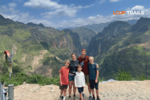
Ha Giang Loop with Toddlers & Very Young Children: Family Jeep Guide
Facebook X Reddit Table of Contents Learn more: Ha Giang Loop Tours Most people picture the Ha Giang Loop as a motorbike

Thúy Kiều (Grace) is a travel blogger and content contributor for Loop Trails Tours Ha Giang. She holds a bachelor’s degree in Sustainable Tourism from Vietnam National University, Hanoi, and has a strong passion for exploring and promoting responsible travel experiences in Vietnam’s northern highlands.

Learn more: Ha Giang Loop Tours
Most people doing the Ha Giang Loop have the same list: Ma Pi Leng Pass, Dong Van Old Quarter, the view from Lung Cu Flag Tower, maybe a bowl of thắng cố in Meo Vac. All great — genuinely. But there’s a village that keeps showing up in whispered recommendations among people who’ve done the loop more than once. A place where the road quiets down, the guesthouses are run by families rather than travel agencies, and the mornings smell like wood smoke and wet rice paddy.
That place is Du Gia.
It’s not unknown — nothing really is anymore — but it’s still operating at a different pace than most stops on the Ha Giang Loop. If you’ve been staring at the map wondering whether to take the longer route through Du Gia or just push straight to Dong Van, this guide is here to help you decide. (Spoiler: take the longer route.)

Learn more: Ha Giang Loop 2 Days 1 Night
Du Gia is a small commune in Bac Me District, Ha Giang Province, sitting in a river valley surrounded by karst mountains and dense forest. It’s part of the Du Gia Nature Reserve — one of the less-visited protected areas in northern Vietnam — and it sits along the Gam River, which gives the whole area a lush, green quality that feels different from the dramatic, stark landscapes further north near Dong Van.
The village is home mainly to Tay ethnic minority communities, along with Dao, Mong, and a few other groups in the surrounding hamlets. Life here revolves around rice farming, fishing, and small-scale agriculture. That’s not a tourism-board description — you’ll actually see it. People working the paddies in the morning. Kids walking home from school along the river road. Older women in traditional dress sitting outside their stilt houses.
What Du Gia isn’t: it’s not a polished destination with a visitor center and a menu of packaged experiences. The infrastructure is basic. That’s exactly why it’s worth going.

Learn more: Ha Giang Loop 3 Days 2 Nights
There’s a tendency on the Ha Giang Loop to chase the highlights — the passes, the viewpoints, the “top 10” photos — and move fast between them. That approach works, and if you only have 3–4 days, you’ll still come away with something memorable.
But Du Gia is the kind of place that rewards slowing down. Here’s why it keeps earning its spot on revised itineraries:
It’s genuinely less crowded. The main tourist flow on the loop tends to follow the northern route through Yen Minh and Dong Van. Du Gia sits on a different section of the road and doesn’t always appear on rushed 3-day schedules. That gap shows — in the guesthouses, on the trails, on the road itself.
The landscape is different. The northern part of the loop is all limestone karst, dramatic and bare. Du Gia is greener, more forested, with river valleys and terraced fields. It’s a visual counterpoint that makes your overall loop experience feel more varied.
It has actual trekking. Most stops on the Ha Giang Loop are scenic viewpoints you drive to. Du Gia lets you get off the bike and walk into something — forest trails, ethnic minority villages, riverside paths. It’s the most legitimately “trekking” destination on the loop.
The community feels intact. It hasn’t reached the point where every interaction is transactional. That changes over time everywhere, but for now, Du Gia still has it.

Learn more: Ha Giang Loop 4 Days 3 Nights
The most common approach from Ha Giang city is to head northeast toward Bac Me, then follow the road along the Gam River into Du Gia. The drive takes roughly 3–4 hours depending on stops, road conditions, and how many times you pull over for photos (answer: many times).
The road through this section is generally in decent condition but can be affected by rain, landslides, and seasonal maintenance work. Check conditions locally before you go — road situations in Ha Giang change faster than any website can track.
This route is a good option if you want to warm up on smoother roads before hitting the more intense northern sections of the loop. Many riders do Ha Giang → Du Gia on day one, then continue north toward Yen Minh, Dong Van, and Meo Vac over the following days.
If you’re coming from the north — having already done Ma Pi Leng Pass and the Nho Que River viewpoint — you can loop back south via Meo Vac and work your way toward Du Gia through the mountain roads of Bac Me District. This is a longer, more remote stretch of road. It’s also, frankly, some of the most beautiful and least-traveled riding on the entire loop.
Road quality varies significantly on this route. Some sections are well-paved; others have been damaged by weather and haven’t been fully repaired. If you’re a first-time rider in Ha Giang, this section is best done with a guide or after getting a real-time conditions update from locals.
A note on permits and documentation: Ha Giang requires a permit for foreign visitors entering the restricted zone. Rules and procedures can change — always verify the latest requirements at the Ha Giang Tourism Department or through your tour operator before your trip.

Learn more: Ha Giang Cao Bang 5 Days 4 Nights
The Du Gia Nature Reserve covers a significant stretch of forested mountain terrain and is home to a variety of wildlife, including primates and bird species rarely seen in more-visited parts of Vietnam. Most visitors don’t come specifically for wildlife spotting, but the trekking itself — even without seeing anything rare — is excellent.
There are trails ranging from easy half-day walks along the river to full-day hikes up into the hills toward neighboring minority villages. Going with a local guide is strongly recommended, not just for navigation (the trails aren’t well-marked) but because many of the most interesting routes pass through privately farmed land and ethnic minority hamlets where a local introduction makes a real difference to how you’re received.
Your guesthouse can usually arrange a guide, or ask around in the village. English may be limited, but gestures and Google Translate get you surprisingly far.
What to bring for a day trek:
")
Learn more: Ha Giang Cao Bang Ba Be Lake 6 Days 5 Nights
Du Gia’s river valley setting is one of its defining features. The Gam River runs through the commune and the surrounding landscape is layered with terraced rice fields that change color dramatically through the seasons — vivid green in early summer, gold in late September through October during harvest, and skeletal and flooded in the off-season.
There are several small waterfalls accessible from the village, some within easy walking distance. Locals can point you toward them — exact locations are best asked about on the ground since access routes change.
Swimming in the river is possible in some spots, but conditions vary by season and water levels. Use local knowledge on this one — don’t assume a calm-looking stretch is safe.
The Tay people are the primary community in Du Gia, with their characteristic wooden stilt houses, traditional textile work, and distinct cultural calendar. If your timing aligns with a local market day — Bac Me and surrounding communes hold periodic markets — it’s worth prioritizing.
These aren’t tourist markets. They’re functional trading events where people from multiple villages come to buy, sell, and socialize. You’ll see everything from livestock to homemade rice wine to handwoven fabrics. Bring cash, be respectful with your camera, and don’t try to bargain on food and staple goods — prices are already low.
Even outside market days, walking through the village in the early morning or late afternoon gives you genuine glimpses of daily life that feel more earned than anything you’d get at a ticketed cultural attraction.
If this kind of off-the-beaten-path riding is what you’re after, have a look at Loop Trails’ Ha Giang Loop tours — including options with local guides who know exactly how to build Du Gia into your route properly.

Learn more: Ha Giang Homestay Guide
Accommodation in Du Gia is basic by most standards and excellent by backpacker standards. You’ll find small family-run guesthouses and homestays, some of them inside traditional stilt houses — which is genuinely one of the better ways to experience the village.
What to expect:
Booking ahead is advisable during peak season (September–November and major Vietnamese holidays). Outside those windows, showing up and finding a room is usually fine, but calling ahead via a translation app never hurts.
Pricing is lower than Ha Giang city or Dong Van — expect to pay less per night for a clean, comfortable room with meals potentially included. Exact prices change seasonally and with the market, so check on arrival rather than relying on outdated figures online.
dapibus leo.

Learn more: Ha Giang Food guide
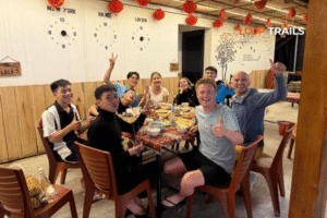
Du Gia doesn’t have a restaurant scene. What it has is better: guesthouse cooking.
Most homestays and family guesthouses will cook for you if you let them know in advance — typically a set dinner with multiple dishes, locally sourced, for a fixed price per person. This is some of the best eating you’ll do on the entire loop. The food leans toward Tay cooking: freshwater fish from the river, foraged vegetables, sticky rice, and various preserved or fermented items that you probably can’t identify but should absolutely try.
A few small eateries operate near the village center, serving pho, bun and basic rice dishes. Nothing fancy, all reliable.
Local food to look for:

Learn more: Ha Giang Buckwheat Flowers Season
Ha Giang’s seasons are distinct, and they affect the Du Gia experience significantly.
| Season | Months | What It’s Like |
|---|---|---|
| Buckwheat flower season | Oct–Nov | Iconic pink flowers bloom across the plateau; peak crowds in the north |
| Rice harvest | Sep–Oct | Golden terraces, best photography, ideal weather |
| Dry season | Nov–Apr | Cooler, clearer, fewer road hazards, less green |
| Rainy season | May–Aug | Lush and green, but landslide risk; some roads may close |
For Du Gia specifically: the September–October harvest window is the most visually rewarding time. The terraced fields turn golden, the weather is generally stable, and the forest is still full and green before the dry season strips it back.
Winter (December–February) brings cold fog and temperatures that can drop surprisingly low at night, especially at altitude. Pack accordingly; the “it’s Southeast Asia, it’ll be warm” assumption fails badly in Ha Giang in January.
Spring (March–May) sees the return of warmth and a secondary flower season, with plum and peach blossoms in some areas earlier in the year.
Avoid the height of the rainy season (July–August) if road conditions are a concern. Landslides are a real hazard, and some routes through Bac Me District can become impassable after heavy rain. Always check local conditions — weather in this region moves fast and road reports online can be days behind reality.

Learn more: Ha Giang Motorbike Rental
This is the part of the guide where you actually decide how you’re going to do this. Du Gia fits into the Ha Giang Loop as a whole, so how you travel the loop determines how you experience Du Gia.
Here’s how the main options break down:

Learn more: Ha Giang Loop Easy Rider
You ride on the back of a motorbike driven by a local guide. Your guide handles navigation, local introductions, restaurant choices, and all the stuff that requires local knowledge and language skills. This is the right option if you want to actually absorb the experience rather than spend mental energy managing logistics, or if you’re not confident on a motorbike in mountain terrain.
Easy Rider tours with a good guide are significantly better in places like Du Gia — your guide can take you to the family guesthouse they actually trust, introduce you to people in the village, and point out the trekking route that doesn’t appear on any map.
Best for: First-timers, solo travelers, couples who prefer to focus on the scenery, anyone who wants the cultural depth without the navigation stress.

Learn more: Ha Giang Loop Self-Drive & hire a motorbike
You ride your own bike. Maximum freedom, you set your own pace, you stop whenever you want. Du Gia is reachable on a self-drive loop, but the Bac Me District roads that lead to and from it are more technical than the main northern circuit. Not impossible — plenty of riders do it — but you should be an experienced rider who is comfortable on unpaved or damaged roads in mountain conditions.
Best for: Experienced riders, people who’ve done the northern loop before and want to explore the less-traveled routes, travelers who genuinely prioritize freedom over support.
")
Learn more: Ha Giang Loop by Jeep for Families & Groups
The jeep option covers similar routes but in a 4WD vehicle with a driver and guide. It’s more comfortable, better for people who want to see the landscape without riding at all, and handles rough roads better than a motorbike in wet conditions. Slower on mountain passes (you lose the visceral riding experience) but better for families, older travelers, or anyone with physical limitations that make riding uncomfortable.
Du Gia by jeep is entirely viable — the key sights are accessible — though some of the smaller trails and hamlet roads are bike-only.
Best for: Families, travelers with mobility considerations, anyone who wants the scenery without the riding.
Not sure which option suits your trip? Drop us a message on WhatsApp — we’ll help you figure out the right fit based on your experience level, group size, and how many days you have.

Learn more: Ha Giang Safety Tips
Cash is essential. There are no ATMs in Du Gia village. Bring enough cash from Ha Giang city or Bac Me town to cover accommodation, food, guide fees, and any incidentals. More than you think you need.
Mobile signal is limited. Viettel has the best coverage in remote Ha Giang; other networks can drop out entirely. Download offline maps (Maps.me or Google Maps offline) before you leave Ha Giang city.
Road conditions change. Particularly on the Bac Me routes, recent rain, construction, or landslides can affect the road. Ask locally before committing to a route — the people at your guesthouse the night before know more than any website.
Respect the villages. This one doesn’t need elaborate explanation: ask before photographing people, be aware when entering homes or communal spaces, and understand that “local color” for your Instagram is someone’s actual home and life.
Hire a local guide for trekking. Even if you consider yourself experienced in the mountains, this isn’t terrain where getting lost is a minor inconvenience. Trails aren’t marked, phone signal is unreliable, and the forest can close in quickly. A guide costs a small amount and is worth significantly more.
The permit situation: Foreign visitors need a permit for the Ha Giang restricted zone. This can usually be arranged through your accommodation in Ha Giang city or through a tour operator. Rules around permits and documentation can change — verify the current process before your trip rather than assuming what applied six months ago still applies today.
Packing checklist for Du Giaspecifically:
Planning a full Ha Giang Loop that includes Du Gia? Our Ha Giang Loop tours cover multiple route options — including the southern Bac Me / Du Gia variation that most travel agencies skip entirely.
")
Learn more: Ha Giang Loop Hidden Gems
Du Gia is a commune in Bac Me District, Ha Giang Province, northern Vietnam. It sits in the Gam River valley, within the Du Gia Nature Reserve, southeast of the main Ha Giang Loop tourist circuit.
It’s not on the most common express loop (Ha Giang → Yen Minh → Dong Van → Meo Vac → back). Du Gia typically requires adding 1–2 days to your itinerary, either as a first or last stop. It’s absolutely worth the extra time if your schedule allows.
The most direct route runs northeast through Bac Me District along the Gam River. Journey time is roughly 3–4 hours depending on road conditions and stops. Road conditions can vary significantly — check locally before you go.
Du Gia is within Ha Giang Province, and foreign visitors to the Ha Giang restricted zone generally require a permit. Requirements and procedures can change — confirm the current rules with your tour operator or the Ha Giang Tourism Department before your trip.
Comfortably: trekking into the nature reserve (half day to full day), visiting the Gam River and nearby waterfalls, exploring the village on foot, eating at your homestay, attending a local market if timing works, and simply doing very little in a very beautiful place. Two days doesn’t feel like too long.
The roads around Du Gia are less technical than Ma Pi Leng Pass or the northern loop highlights, but the Bac Me District routes are still mountain roads with unpaved sections, hairpin turns, and weather-related hazards. If you’re a first-time rider in Ha Giang, an Easy Rider (guided) option is a safer call.
September to November is generally ideal — harvest season brings golden rice terraces, weather is more stable, and the landscape is at its most photogenic. Spring (March–May) is also good. Peak rainy season (July–August) carries the highest risk of landslides and road closures.
No. Bring sufficient cash from Ha Giang city or Bac Me town. There are no ATMs in Du Gia village, and card payment is not available at guesthouses or local eateries.
The Tay people are the predominant community, with Dao, Mong, and other groups in surrounding hamlets. Each has distinct traditions, dress, and cultural practices — one of the genuine draws of spending time in the area versus simply passing through.
Yes Ha Giang and Cao Bang are geographically adjacent, and combining both into an extended northern Vietnam loop makes a lot of sense. Du Gia sits on a natural route between the two provinces. Check Loop Trails’ Ha Giang–Cao Bang combine tours if this interests you.
Prices are lower than Ha Giang city or Dong Van — guesthouses and homestays are generally budget-friendly, with meals often available at the same property. Exact prices fluctuate with seasons and demand; check on arrival rather than relying on outdated information.
Generally yes — the village is quiet and community-oriented, and crime directed at tourists is not a feature of this area. The main safety considerations are road conditions and trekking (use a guide). Exercise standard situational awareness, particularly on the road.
Contact information for Loop Trails
Website: Loop Trails Official Website
Email: looptrailshostel@gmail.com
Hotline & WhatSapp:
+84862379288
+84938988593
Social Media:
Facebook: Loop Trails Tours Ha Giang
Instagram: Loop Trails Tours Ha Giang
TikTok: Loop Trails
Office Address: 48 Nguyen Du, Ha Giang 1, Tuyen Quang
Address: 48 Nguyen Du, Ha Giang 1, Tuyen Quang
Facebook X Reddit Table of Contents Learn more: Ha Giang Loop Tours Most people picture the Ha Giang Loop as a motorbike

Facebook X Reddit Table of Contents Learn more: Ha Giang Loop Tours Riding the Ha Giang Loop during Tet is one of
Facebook X Reddit Table of Contents Learn more: Ha Giang Loop Tours Dong Van sits at the far northern tip of Vietnam,