
Ha Giang Cao Bang Packing List: 5-6 Days Adventure Essentials Guide
Facebook X Reddit Table of Contents Why Packing Right Changes Your Ha Giang-Cao Bang Experience Learn more: Ha Giang Loop Tours I’ve

Thúy Kiều (Grace) is a travel blogger and content contributor for Loop Trails Tours Ha Giang. She holds a bachelor’s degree in Sustainable Tourism from Vietnam National University, Hanoi, and has a strong passion for exploring and promoting responsible travel experiences in Vietnam’s northern highlands.

Learn more: Ha Giang Loop Tours
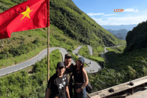
There’s a moment roughly an hour out of Ha Giang city when the road tilts sharply upward, the air cools, and the valley below suddenly drops away. You come around a bend and there it is — a stone arch framing a view so dramatic it almost feels theatrical. Two perfectly symmetrical green hills rise from a patchwork of terraced fields, mist drifting between the karst peaks beyond. This is Quan Ba Heaven Gate, and it’s the first proper “stop the bike” moment on the Ha Giang Loop.
If you’re planning the loop for the first time — or trying to figure out whether this stop is worth your time — this guide covers everything: what’s actually there, how long to spend, when to go, and how it fits into the bigger picture of a Ha Giang itinerary.

Learn more: Ha Giang Loop 2 Days 1 Night
Quan Ba Heaven Gate (Cổng Trời Quản Bạ in Vietnamese) is a mountain pass and viewpoint in Quan Ba District, Ha Giang Province. Sitting at roughly 1,500 metres above sea level, it marks the point where the road crosses into the high plateau karst landscape that defines the rest of the loop.
The “gate” part is literal — there’s an actual stone archway spanning the road, built to mark the transition between the lower valleys and the dramatic highland terrain ahead. Pass through it and you’ve entered a different world.

Learn more: Ha Giang Loop 3 Days 2 Nights
The real draw isn’t the arch. It’s the view from the platform above it: the Twin Mountains (Núi Đôi, also called the Fairy Bosom Mountains — Núi Cô Tiên). According to local H’mong legend, a fairy fell in love with a human man. When the gods forced her back to the heavens, her grief left behind two rounded hills in the valley below as a permanent mark of the story.
Whether you buy the legend or not, the visual is undeniably striking. The two hills are almost perfectly symmetrical, rising from the flat valley floor of Tam Son in a way that looks more like deliberate landscaping than geology. Pair that with the surrounding karst backdrop and you can understand why this spot has become the de facto “first photo stop” of any Ha Giang Loop itinerary.

Learn more: Ha Giang Loop 4 Days 3 Nights
Practically speaking, Quan Ba functions as a psychological threshold. You’ve left the outskirts of Ha Giang behind. The roads ahead are narrower, the villages more remote, the scenery increasingly surreal. First-time riders often say Quan Ba is where the trip “actually started” — where the elevated altitude and dramatic landscape confirmed that everything they’d read about this place was real.
It’s also the first point on the route where riders with no experience of mountain roads start to understand what they’ve signed up for.

Learn more: Ha Giang Cao Bang 5 Days 4 Nights
Quan Ba Heaven Gate sits approximately 46 kilometres north of Ha Giang city along National Route 4C (QL4C). On paper, that doesn’t sound far. In practice, allow at least 1.5 to 2 hours for this leg — longer if you stop, which you will.
The road out of Ha Giang starts flat and manageable. After the town of Vi Xuyen, it begins to rise. By the time you’re approaching the Quan Ba pass, you’re navigating a series of tight switchbacks with significant elevation gain. The road surface is generally paved, but sections can be affected by landslides, erosion, or repair work — conditions that shift with the seasons and after heavy rain.
A few things to know before you ride this stretch:
Riders who’ve done alpine roads elsewhere will find this manageable. For first-timers on Vietnamese semi-automatic bikes, it’s a genuine workout. The grades are steep enough that you’ll be in low gear for sustained stretches. On the way down from the viewpoint heading north, the same logic applies in reverse — engine braking is your friend; your brakes alone are not.
This is one of the reasons a lot of first-time Ha Giang visitors opt for a guided Easy Rider tour or a Jeep for at least the first loop. More on that below.

Learn more: Ha Giang Cao Bang Ba Be Lake 6 Days 5 Nights
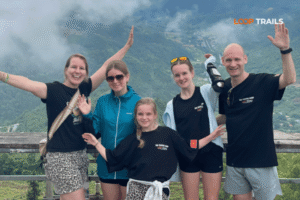
There’s a dedicated viewing area at the Heaven Gate summit — a paved terrace with railings overlooking the valley. It’s accessible directly from the roadside. You can park your bike (or step off the Jeep) and walk to the edge in about two minutes.
The view faces southwest, down into the Tam Son valley. On a clear day, the depth of field is remarkable — terraced rice fields in the immediate foreground, the Twin Mountains in the mid-ground, and wave after wave of karst limestone peaks extending to the horizon. On overcast days or when cloud is low, there’s a different kind of magic: the valley fills with mist and the peaks appear in layers, like a Chinese ink painting.
There are a few souvenir vendors and food stalls at the top. Nothing fancy, but you can get a coffee or a snack while you absorb the view.
Looking down, you can see Tam Son — the small market town at the base of the pass. It’s the administrative centre of Quan Ba District and a common overnight stop for riders doing a slower, more relaxed loop. The town sits in a broad valley and has a modest but functional set of guesthouses, restaurants, and a colourful weekly market (Sundays, though check locally for current schedule).
If you’re tight on time, you might bypass Tam Son. But if you want to spend a night somewhere quieter and more authentically local before hitting the busier Dong Van and Meo Vac stretch, it’s a solid option.
From the viewpoint, the Twin Mountains appear in the near distance. For a closer look, you need to descend into the valley — there’s no trail to the summits themselves that’s developed for tourists, but riding down and around them gives a totally different perspective. Seen from the valley floor, they’re even more impressive: two almost-perfect domes rising from flat agricultural land, with H’mong villages scattered at their base.

Learn more: Ha Giang Loop Weather
Ha Giang has two dominant seasons that define what you’ll see at Quan Ba:
Dry season (October–April): Clearer skies, better visibility from the viewpoint, cooler temperatures — especially at altitude. Late October through November is peak buckwheat flower season in the highlands, though the flowers are more concentrated further north around Dong Van. Still worth considering if colour is your priority.
Wet season (May–September): Rice terraces are lush and brilliantly green, which makes for spectacular landscape photography. The downside is rain, reduced visibility at altitude, and a higher risk of landslides on mountain roads. If you travel in this window, July and August carry the highest rainfall — not impossible, but you need flexibility and realistic expectations.
The single most popular time for the Ha Giang Loop overall is October to early December. The weather is clear, the temperatures are comfortable, and the landscape shifts between harvest gold and winter stark. Quan Ba in this window, on a clear morning, is genuinely stunning.
Early morning (7–9am) is the sweet spot. The valley holds morning mist, the light is soft and directional, and there’s almost nobody else at the viewpoint. By midday, tour groups have started arriving and the light is harsh.
Late afternoon (4–5pm) can also be beautiful — golden hour light on the valley — but you need to calculate your road time carefully. Riding mountain passes in fading light is not ideal.
If you’re staying in Tam Son town, you can time your visit to the viewpoint easily. If you’re day-riding from Ha Giang, leave early.

Learn more: Ha Giang Motorbike Rental
Realistically, the viewpoint itself warrants 30–45 minutes. That’s enough for photos, a short walk around the platform, and a quiet moment looking at the valley before moving on.
If you want to descend into Tam Son and get a look at the Twin Mountains from below, add another 30–60 minutes. And if you’re stopping for lunch in town or visiting the market, a two-hour block is comfortable.
Most guided Easy Rider and Jeep tours schedule Quan Ba as a mid-morning stop on Day 1, then continue to Yen Minh or Dong Van for the night. Self-drivers set their own pace, which is one of the genuine advantages of that option.

Learn more: Ha Giang Loop route and itinerary
The classic Ha Giang Loop runs roughly: Ha Giang City → Quan Ba → Yen Minh → Dong Van → Meo Vac → (Du Gia or direct return) → Ha Giang City. Quan Ba is the first stop — the opening scene of the whole journey.
This matters for pacing. Some riders rush through Quan Ba to “save time for Ma Pi Leng Pass” and reach Dong Van faster. That’s understandable, but it shortchanges one of the loop’s more accessible and genuinely photogenic stops. You don’t need to linger for hours, but the Heaven Gate viewpoint deserves more than a five-minute photo.
After Quan Ba, the road continues north through Yen Minh — a larger town with good food and accommodation options — before entering the Dong Van Karst Plateau Geopark. The landscape becomes progressively more dramatic: deeper gorges, higher passes, more isolated H’mong villages. The Ma Pi Leng Pass (between Dong Van and Meo Vac) is widely considered the highlight of the entire loop, and the Nho Que River gorge below it is one of the most photographed spots in northern Vietnam.
Quan Ba sets the tone for all of that. Think of it as the prologue.
Some riders extend the loop to include Lung Cu (Vietnam’s northernmost flag tower) and Pho Cao or combine the Ha Giang Loop with Cao Bang (Ban Gioc Waterfall, Nguom Ngao Cave, Phia Oac mountain). These combo routes add significant time but offer a genuinely complete picture of the far northeast. If that’s on your radar, worth checking out the Ha Giang–Cao Bang combined tours that cover both regions in one itinerary.

Learn more: Ha Giang Loop Easy Rider
Thinking about doing the Ha Giang Loop and figuring out which format works for you? Here’s an honest breakdown.
You sit on the back of a motorbike piloted by an experienced local guide. No driving licence required for passengers. Your guide handles navigation, explains the cultural context, knows the roads, and can communicate with locals. Ideal for travellers who want to absorb the scenery without the cognitive load of riding a new road in a foreign country.
Loop Trails’ Easy Rider option runs in small groups with English-speaking guides who know this route well. It’s the most popular option among first-time Ha Giang visitors for good reason.

Learn more: Ha Giang Loop Self-Drive & hire a motorbike
You ride your own bike (rented or yours). Full autonomy — you stop when you want, spend as long as you like at Quan Ba or anywhere else, and set your own daily pace. The trade-off is that you’re responsible for navigation, mechanical issues, and your own safety on mountain roads.
Ha Giang motorbike rental is straightforward if you book through a reputable provider. Loop Trails offers semi-auto and manual options including XR150s — check current availability and specifications directly, as stock and terms can vary.
Important: Driving licence requirements and regulations for foreigners riding in Vietnam can and do change. Check the current rules before you go — don’t rely on what was true a year ago.

Learn more: Ha Giang Loop by Jeep for Families & Groups
A private or small-group tour in a 4WD Jeep. More comfortable, weather-proof, and better suited for travellers who aren’t confident on two wheels but still want the loop experience. Also popular with couples, older travellers, and anyone with gear they don’t want to strap to a motorbike.
| Easy Rider | Self-Drive | Jeep | |
|---|---|---|---|
| Riding experience needed | None | Yes | None |
| Physical effort | Low | High | Low |
| Flexibility | Moderate | Full | Moderate |
| Cultural interaction | High (guide translates) | Variable | Moderate |
| Best for | First-timers, solo, curious travellers | Experienced riders, independent spirits | Couples, comfort-seekers, non-riders |
Not sure which fits your trip? [Get in touch via WhatsApp] and the Loop Trails team can help you figure it out based on your experience, timeline, and budget.

Learn more: Ha Giang Loop Photography
A few things that bear repeating for riders heading from Ha Giang to Quan Ba:
Lorem ipsum dolor sit amet, consectetur adipiscing elit. Ut
There’s no specific scam culture around Quan Ba compared to busier tourist sites, but a few general watch-points for the Ha Giang Loop overall:
elit tellus, luctus nec ullamcorper mattis, pulvinar dapibus leo.

Learn more: Ha Giang Safety Tips
The viewpoint itself has small vendors selling snacks and drinks — budget for loose change. For a proper meal, Tam Son town (a short descent from the pass) has several local restaurants serving standard Vietnamese fare: pho, com (rice dishes), noodle soups. Nothing fancy, but honest and affordable.
If you’re heading to Yen Minh on Day 1, that town has better dining variety. For those staying overnight in Tam Son, the food options are functional rather than adventurous — set expectations accordingly.
Tam Son has a handful of guesthouses and small hotels. Prices are generally low by any standard — this is deep rural Vietnam. The tradeoff is basic facilities. Hot water, WiFi, and clean rooms are usually available, but don’t expect boutique.
For specific current pricing and availability, check booking platforms closer to your travel date — availability and rates shift seasonally and with the volume of loop traffic.
This guide won’t quote specific admission or parking fees since these can change and vary by season. What’s consistently true: the Ha Giang Loop is one of Vietnam’s most affordable multi-day trips. Accommodation, food, and petrol costs are low. Your main spend is on transport (tour cost or rental fee) and any accommodation upgrades you choose.

Learn more: Ha Giang Loop Mistake to Avoid
Yes, especially if it’s your first time on the Ha Giang Loop. The Twin Mountain view is genuinely unlike anything else in Vietnam and it’s easy to access directly from the road. Budget at least 30–45 minutes.
Approximately 46 kilometres by road. Allow 1.5–2 hours depending on road conditions, your pace, and any stops along the way.
Technically yes, but it would be a short round-trip with not much time at the top. Most travellers use Quan Ba as the first stop of a multi-day loop rather than a standalone excursion. If the full loop isn’t possible, consider at least continuing to Yen Minh and returning.
As of recent reports, no entrance fee or permit is required for the viewpoint itself. Regulations can change — check locally before your trip.
October through early December offers the most reliable clear skies and comfortable temperatures. Late May through September brings lush greenery but also rain and potential road issues. Avoid peak summer months if mountain road safety is a concern.
The stretch from Ha Giang to Quan Ba includes significant switchbacks and elevation gain. Riders with no mountain road experience should seriously consider a guided Easy Rider tour or Jeep option rather than self-driving. This isn’t meant to discourage — it’s a practical assessment of the road.
Two symmetrical rounded hills rising from the Tam Son valley floor. They’re a geological feature with local H’mong legend attached and are the main photographic focal point from the Heaven Gate viewpoint.
There’s no developed tourist trail to the summits. You can drive down into the valley for a close ground-level view, and walk around their base through farmland, but organised trekking routes to the tops don’t exist in the same way as dedicated hiking trails elsewhere.
Heading north: Yen Minh (good overnight option), then Dong Van (historic H’mong quarter, Dong Van Karst Geopark), then the Ma Pi Leng Pass and Meo Vac. The route then either heads back via Du Gia or loops back directly to Ha Giang.
The viewpoint is at the top of the pass with no accommodation there. Tam Son town, a short distance down into the valley, is the nearest overnight option.
If you have 7+ days and a genuine interest in remote northern Vietnam, yes. The combination of the Ha Giang Loop with Cao Bang (Ban Gioc Waterfall, Nguom Ngao Cave, the road through Phia Oac) is one of the best overland routes in the country. Loop Trails offers combined itineraries for exactly this — worth exploring if you want to extend the trip.
Yes. All Loop Trails Ha Giang itineraries — Easy Rider, Self-Drive, and Jeep — pass through Quan Ba Heaven Gate as a standard stop on Day 1 of the loop.
Contact information for Loop Trails
Website: Loop Trails Official Website
Email: looptrailshostel@gmail.com
Hotline & WhatSapp:
+84862379288
+84938988593
Social Media:
Facebook: Loop Trails Tours Ha Giang
Instagram: Loop Trails Tours Ha Giang
TikTok: Loop Trails
Office Address: 48 Nguyen Du, Ha Giang 1, Tuyen Quang
Address: 48 Nguyen Du, Ha Giang 1, Tuyen Quang
Facebook X Reddit Table of Contents Why Packing Right Changes Your Ha Giang-Cao Bang Experience Learn more: Ha Giang Loop Tours I’ve
Facebook X Reddit Table of Contents Why Northern Vietnam Deserves Your 14 Days Learn more: Ha Giang Loop Tours Two weeks in
Facebook X Reddit Table of Contents Learn more: Ha Giang Loop Tours Deciding when to tackle the Ha Giang–Cao Bang combo isn’t