
Two UNESCO Geoparks in One Trip: Dong Van + Non Nuoc
Facebook X Reddit Table of Contents Learn more: Ha Giang Loop Tours If you’ve been dreaming about Vietnam’s limestone karst landscapes but

Thúy Kiều (Grace) is a travel blogger and content contributor for Loop Trails Tours Ha Giang. She holds a bachelor’s degree in Sustainable Tourism from Vietnam National University, Hanoi, and has a strong passion for exploring and promoting responsible travel experiences in Vietnam’s northern highlands.
")
Learn more: Ha Giang Loop Tours
The first morning of the Ha Giang Loop is a strange combination of excitement and nerves. You’ve heard about the road. You’ve seen the photos. And now you’re standing in Ha Giang city with a full tank, a backpack strapped down, and about 60 kilometres between you and tonight’s guesthouse in Quan Ba.
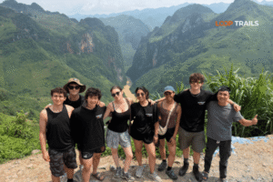
Day 1 is not the most dramatic day of the Loop — that crown belongs to the Ma Pi Leng section further north. But it is the day that tells you what kind of trip this is going to be. The road climbs quickly, the landscape shifts from lowland farmland to limestone karst almost immediately, and by the time you reach Heaven Gate, most people have already forgotten what they were stressed about.
This guide covers every major stop on the Ha Giang Loop Day 1 route, from the first mountain switchbacks at Bac Sum Pass to the quiet valley town of Quan Ba, with practical notes on timing, road conditions, food stops, and how to do this day well — whatever transport option you’ve chosen.
")
Learn more: Ha Giang Loop 2 Days 1 Night
The standard Day 1 route follows National Highway QL4C north from Ha Giang city toward Quan Ba, covering roughly 50 to 65 kilometres depending on how many side detours you take. Don’t let that distance fool you — this road takes longer than you think. The passes have switchbacks, the viewpoints beg you to stop, and if you’re doing it right, you’ll be pulling over every twenty minutes.
The three main landmarks are:
You’ll arrive in Quan Ba town in the late afternoon if you pace things reasonably, giving you time to explore on foot before dinner. Some groups push a little further on Day 1 — there are options — but Quan Ba is the natural and most logical overnight stop for the first night.

Learn more: Ha Giang Loop 3 Days 2 Nights
Starting point: Ha Giang city (most guesthouses / hotels are within a few minutes of the main road heading north) End point: Quan Ba town Total distance: approximately 50–65 km via QL4C Estimated riding time (excluding stops): 2 to 2.5 hours Realistic total time with stops: 4 to 6 hours
The road out of Ha Giang city is smooth and unremarkable for the first few kilometres. You’ll pass the city’s outskirts, cross the Lo River, and the road starts climbing within 15 minutes. Once you hit the first real switchbacks, you’re officially on the Loop.
Road quality on this section is generally good compared to further north QL4C was resurfaced in recent years and the Day 1 route is the least technical of the whole loop. That said:
Planning the full Loop from scratch? Check out our [Ha Giang Loop tours page] to see what’s included across our easy rider, self-drive, and jeep options and whether you’d rather ride your own bike or let someone else handle the driving.

Learn more: Ha Giang Loop 4 Days 3 Nights
Bac Sum Pass (locally written as Đèo Bắc Sum or sometimes spelled Bắc Sơn depending on the map) is the first major pass you hit on the Loop. It sits at around 1,200 metres above sea level and the road up is a series of tight, well-graded switchbacks that take you out of the valley quickly.
There’s no single dramatic viewpoint at Bac Sum the way there is at Heaven Gate — the reward here is the drive itself, and the sudden shift in landscape you notice as you reach the top. Below you was river valley and green farmland. Up here, the terrain turns rocky and the air has a different weight to it.
A few things worth noting at Bac Sum:
Don’t spend too long here Bac Sum is a warm-up, and Heaven Gate is 25 to 30 kilometres further.

Learn more: Ha Giang Cao Bang 5 Days 4 Nights
Heaven Gate, known in Vietnamese as Cổng Trời Quản Bạ (“Sky Gate” or “Gate to Heaven”), is arguably the single best viewpoint accessible on a day-1 itinerary. The name comes from a literal stone archway built into the mountainside that you drive through beyond it, the road dips and the valley of Quan Ba opens up beneath you.
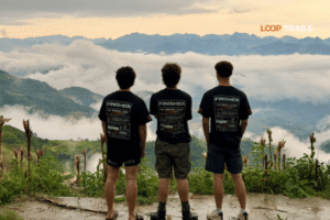
The viewpoint here faces south (looking back toward where you came from) and gives you a panorama of terraced paddy fields, small ethnic minority villages, and the karst peaks that define this landscape. In the right season October is particularly good, with harvested gold rice fields this is the kind of view that stops a conversation mid-sentence.
At the peak of the pass, there’s a formal observation area with a stone terrace. Entrance is paid, and it’s worth paying (the exact fee can change so check when you arrive it’s a small amount). The archway itself marks the official boundary between Ha Giang city and Quan Ba district.
What season are you visiting?
If Day 1 of the Ha Giang Loop produces one photograph you’ll actually print and hang somewhere, it comes from this spot.

Learn more: Ha Giang Cao Bang Ba Be Lake 6 Days 5 Nights
From Heaven Gate, the road descends into Quan Ba valley — and the descent is excellent. Well-surfaced switchbacks curve down through forest with the valley spreading out ahead of you as you go lower. The Twin Mountains appear as you get closer to town, and they’re immediately recognisable: two almost perfectly dome-shaped limestone karst hills rising from flat paddy fields, sitting side by side with startling symmetry.
The local H’mong name for these hills translates loosely to “Fairy Bosom Mountain” (Núi Đôi Cô Tiên), which is accurate and makes every conversation about them at least a little more memorable.
The story behind the name: a celestial fairy fell in love with a human man and the two had a child together. When she was summoned back to heaven, she was so heartbroken about leaving her baby that her milk transformed into these two hills — to forever nourish the valley and the people below. It’s one of those local legends that somehow makes the landscape feel even more specific.
Whether or not you’re into folklore, the hills are genuinely striking from the valley floor, especially in early morning light or at golden hour. There’s a viewpoint accessible by a short walk or jeep track from town that gives you a straight-on view of both peaks with the rice fields in the foreground ask your guide or guesthouse for directions.
Quan Ba town is small. Accommodation options are limited but functional there are a handful of guesthouses and small hotels that cater to Loop travelers. Expect clean rooms, basic amenities, and not much more. A few notes:
If your tour is arranged with Loop Trails, your accommodation on Day 1 is included and pre-arranged. If you’re self-driving independently, it’s worth confirming a room before you leave Ha Giang in the morning.

Learn more: Ha Giang Motorbike Rental
This is the question we get most often, and the honest answer is: it depends on you. Day 1 is a good test case because the road is manageable, the stops are clear, and the stakes for getting it wrong are lower than on the more technical sections further north.
Here’s a straightforward breakdown:
Self-drive motorbike: Best for experienced riders who are comfortable with mountain switchbacks. You control the pace completely, stop whenever you want, and the experience is immersive in a way nothing else matches. The Bac Sum and Heaven Gate passes are well within the ability of a competent rider. Hire a decent semi-automatic (XR150-type) rather than an automatic if you want more confidence on the climbs.
Easy rider (motorbike with local driver): You sit on the back, your driver handles everything. This is a great option if you’re not confident on mountain roads, if you want to just look around rather than focus on the road, or if this is your first experience in Vietnam traffic. Local easy rider guides know the stops, know the vendors, and often know things about the route that no travel blog covers.
Jeep tour: The jeep option covers the same stops and the same views. You’re in an open-air vehicle (or enclosed, depending on the jeep type), elevated above the road, with a guide and driver. On Day 1, the jeep is particularly comfortable because the road is good and you can genuinely sit back and take in the passing landscape. Couples, families, and travelers who have come specifically for the views rather than the riding experience tend to find this the right fit.
Not sure which format suits you? Take a look at our [Ha Giang Loop tour options] we offer all three formats (easy rider, self-drive, and jeep) and can help you choose based on your riding background and what you’re hoping to get from the trip. Drop us a message on WhatsApp if you want to talk it through first.

Learn more: Ha Giang Food guide
Recommended departure: 7:30 to 8:30 AM from Ha Giang city. Leaving earlier (6:30 AM) is possible and means cooler temperatures and lighter traffic, but fog at the passes is more likely. Leaving after 9 AM is fine but you’ll be at Heaven Gate during peak midday light, which is harsher for photos and hotter for riding.
Fill up completely in Ha Giang city before leaving. There are petrol stations in Quan Ba, but between the two towns, options are thin. Some small roadside shops sell petrol from plastic bottles usable in an emergency, but better to not need it.

Learn more: Ha Giang Loop Self-Drive
Road hazards: gravel on bends after rain, cattle and water buffalo on the road (common), trucks overtaking on blind corners (give them room, not a horn).
Weather changes fast at altitude. It can be warm in the valley and cold at the pass simultaneously. A light rain jacket in your day bag is not optional it’s standard kit for the Loop regardless of season.
Don’t rely on Google Maps for this route. Offline maps (Maps.me or downloaded Google Maps offline) are more reliable in areas with poor signal. Signal drops in and out on QL4C.
Photo stops: everyone wants the Heaven Gate photo, and if you’re in a group, someone will always need “one more shot.” Build this into your timing. Budget 30 to 45 minutes at Heaven Gate and don’t feel rushed.
Scams and hassle: Day 1 on the main QL4C is low-risk for scams. The occasional overpriced vendor at tourist viewpoints is the extent of it. Paying a reasonable amount for a coffee or snack at the Heaven Gate cafe is just how it works you don’t need to negotiate hard.

Learn more: Ha Giang Loop by Army Jeep Tours
Day 1 is just the beginning. The route continues through some of the most dramatic mountain road scenery in Southeast Asia Dong Van old quarter, the Ma Pi Leng Pass, Meo Vac and the Nho Que River gorge below it, and on longer itineraries, side routes through Du Gia or up to Lung Cu flag tower at Vietnam’s northernmost point.
If you’re doing the full Loop:
For travelers interested in extending further into Cao Bang province after the Loop (Ban Gioc Waterfall, Nguom Ngao Cave, the Phia Oac highlands), the Ha Giang and Cao Bang combined tour adds three days and is worth every one of them.
Take a look at the full [Ha Giang and Cao Bang combine tour] to see how the itinerary works and what’s included. It’s a longer commitment but one of the best road trips in northern Vietnam.

Learn more: Cao Bang Loop 3 Days best kept secret
Approximately 50 to 65 kilometres along QL4C, depending on the exact route taken. With stops at Bac Sum, Heaven Gate, and around Quan Ba, plan on 4 to 6 hours total including the viewpoint visits.
Day 1 is the most beginner-friendly section of the Loop. The passes have clear switchbacks with reasonable visibility and the road surface is generally well-maintained. That said, if you have little or no motorcycle experience, the easy rider or jeep option is the smarter choice — not because the road is dangerous, but because you’ll enjoy it more when you’re not focused entirely on the riding.
There is a small entrance fee to the observation terrace at Heaven Gate. The exact amount can change — check on arrival. It’s inexpensive and the viewpoint is worth it.
October is widely considered the best month: clear skies, golden rice terraces, and cooler riding temperatures. March and April are excellent for buckwheat flowers. The rainy season (May to September) brings mist and green landscapes but also unpredictable visibility at the passes.
Yes the route follows QL4C and is well-signed. Offline maps cover the route. However, having a local guide (easy rider format) adds context, inside knowledge about stops, and removes all the logistical thinking. First-time Vietnam riders often find the guide format significantly less stressful.
Bac Sum Pass is located roughly 15 to 20 km north of Ha Giang city on QL4C. It’s the first major mountain pass you hit after leaving the city, and it serves as a visual announcement that the Loop has begun.
There is limited banking infrastructure in Quan Ba. Withdraw cash in Ha Giang city before departing carrying enough for accommodation and meals in Quan Ba and the following day’s journey is strongly recommended. Card acceptance is rare in small towns on the Loop.
Some itineraries skip Quan Ba as an overnight and continue to Yen Minh, which adds another hour or more of riding. This is possible on good days with an early start, but it compresses the stops and means rushing through Heaven Gate. Most travelers find Quan Ba the right pace for Day 1
Day 1 is excellent by jeep. The road quality is good, all major viewpoints are accessible, and the elevation changes feel dramatic from the higher vantage point of a 4WD vehicle. The Twin Mountains viewpoint in Quan Ba is particularly striking from the jeep track approach.
Rain jacket, offline map downloaded, sun protection (the passes can be deceptively sunny), snacks for the road, and a power bank. Leave anything you don’t need for the day in your main bag — a small daypack or handlebar bag is easier than a fully loaded backpack for short touring days
The Quan Ba valley is home to several ethnic minority communities, primarily the H’mong (both Flower H’mong and White H’mong), Tay, and Dao people. Villages visible from the road are often traditional settlements. If you stop to photograph, ask before pointing a camera at people it’s respectful and usually appreciated.
The fastest way is to check availability on our [Ha Giang Loop tour page] and either book directly or send us a message on WhatsApp. We offer easy rider, self-drive, and jeep format across 2D1N, 3D2N, and 4D3N itineraries. Most guests book 1 to 3 months ahead, particularly for peak season (October and March/April).
Contact information for Loop Trails
Website: Loop Trails Official Website
Email: looptrailshostel@gmail.com
Hotline & WhatSapp:
+84862379288
+84938988593
Social Media:
Facebook: Loop Trails Tours Ha Giang
Instagram: Loop Trails Tours Ha Giang
TikTok: Loop Trails
Office Address: 48 Nguyen Du, Ha Giang 1, Tuyen Quang
Address: 48 Nguyen Du, Ha Giang 1, Tuyen Quang
Facebook X Reddit Table of Contents Learn more: Ha Giang Loop Tours If you’ve been dreaming about Vietnam’s limestone karst landscapes but
Facebook X Reddit Table of Contents Learn more: Ha Giang Loop Tours When I first heard about Vietnam’s cave systems, I imagined
Facebook X Reddit Table of Contents Learn more: Ha Giang Loop Tours If you’re dreaming of high-altitude peaks, hidden waterfalls, and trails