
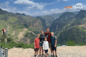
Ha Giang Loop with Toddlers & Very Young Children: Family Jeep Guide
Facebook X Reddit Table of Contents Learn more: Ha Giang Loop Tours Most people picture the Ha Giang Loop as a motorbike

Thúy Kiều (Grace) is a travel blogger and content contributor for Loop Trails Tours Ha Giang. She holds a bachelor’s degree in Sustainable Tourism from Vietnam National University, Hanoi, and has a strong passion for exploring and promoting responsible travel experiences in Vietnam’s northern highlands.

Learn more: Ha Giang Loop Tours
There’s a version of the Ha Giang Loop that most travelers experience from the back of a motorbike or crammed into a Jeep. And then there’s the version you get on a bicycle — slower, louder in your lungs, and completely different in a way that’s hard to explain until you’ve done it.
Cycling the Ha Giang Loop is not a casual weekend ride. The climbs are long, the roads demand attention, and some days you’ll cover barely 60 kilometers while burning through everything you have. But the payoff? You actually feel the landscape instead of just passing through it. You stop when you want. You earn every view.
This guide covers the full picture: the route, the elevation reality, what bike to use, when to go, how to stay safe, and whether you even need a support vehicle. No fluff, no padding — just what you actually need to know before you clip in (or strap on your panniers) and head north.
")
Learn more: Ha Giang Loop 2 Days 1 Night
Short answer: yes. People do it every year, from solo bikepacking travelers to small groups with a support van. It’s not a technical ride in the mountain biking sense — there’s no singletrack, no jumps, no technical descents requiring a full-suspension rig. What it is, is a long, relentless road cycling challenge through one of the most remote and spectacular regions in Southeast Asia.
The Ha Giang Loop covers roughly 350 kilometers of paved mountain road, depending on your exact route. Total elevation gain across the full loop sits somewhere in the range of 6,000 to 8,000 meters depending on your route variation and how accurately your GPS tracks the small rollers between major passes. The climbs are not technical, but they are sustained. Ma Pi Leng Pass, the most famous section, involves a long approach and a descent that rewards you with views of the Nho Que River far below.
The road surface is mostly paved and in reasonable condition, though sections deteriorate after heavy rain or during road construction seasons. You won’t be riding gravel or dirt for the majority of the loop — but you should expect patches of rough tarmac, narrow lanes, and occasional loose debris near cliff edges.
Most cyclists complete the loop in 4 to 6 days. Faster riders push it in 3. If you want to explore side routes, stop at villages, and actually enjoy the scenery without destroying your body, plan for 5 or 6 days minimum.
You’ll have a great time cycling the Ha Giang Loop if you:
You might want to reconsider (or at least plan more carefully) if:
None of this is meant to scare you off. It’s meant to help you prepare properly, because the loop rewards preparation and punishes people who underestimate it.
The classic Ha Giang Loop runs counterclockwise: Ha Giang city north to Quan Ba, then Yen Minh, Dong Van, Meo Vac, and back south through Du Gia and Bac Me. Some cyclists do it clockwise, but counterclockwise is more common because it puts the best scenery (Ma Pi Leng, Dong Van) in the middle of the trip rather than at the start.
Here’s a practical day-by-day breakdown based on a 4-day ride. Adjust stages to suit your pace.
")
Learn more: Ha Giang Loop 3 Days 2 Nights
Distance: approximately 100 km to Yen Minh, or shorter if you stop at Quan Ba Elevation: the first serious climb comes at Heaven’s Gate (Quan Ba), which gives you a preview of what’s ahead
The first day is your calibration day. The road out of Ha Giang city is straightforward and gives you time to settle into a rhythm before the climbing starts in earnest. Quan Ba offers the Twin Mountains viewpoint and a reasonable guesthouse scene if you want to break the stage early. Yen Minh is a small town with a few accommodation options and a decent night market — a good base if you’re pushing through on day one.
If you’re adding Du Gia to your loop (highly recommended), this is where you fork off. Du Gia is a quieter valley with a waterfall, minority villages, and a totally different feel from the rocky karst plateau you’ll hit on days 2 and 3. The road into Du Gia is narrower and more rural, which is part of the appeal.
Distance: approximately 50 to 60 km Elevation: long rolling climbs through plateau grasslands, more gradual than dramatic
This stage is scenic in a subtler way. The rocky plateau opens up between Yen Minh and Dong Van, and if you time it right you’ll be riding through fields of buckwheat flowers (October and November) or golden grass. The road quality on this stretch is generally good. Dong Van town itself is worth arriving at with some daylight left — the old quarter, the Sunday market, and the general atmosphere of being this deep in the mountains all hit differently when you’re not rushing.
Dong Van is the furthest point north on the loop. Lung Cu Flag Tower, the northernmost tip of Vietnam, is about 24 km from town and worth an out-and-back detour if your legs can handle it.
Distance: approximately 25 km between the towns, but plan for more time than the numbers suggest Elevation: this is the signature climb of the entire loop
This is the day most people talk about when they talk about Ha Giang. Ma Pi Leng Pass is a 20-kilometer-or-so ridge road carved into the cliff face above the Nho Que River gorge. The views are extraordinary — genuinely one of the most dramatic road landscapes in Southeast Asia. There are viewpoints where you can stop, look down at the green river hundreds of meters below, and feel very small and very grateful to be there.
On a bicycle, this stretch takes longer than it looks on a map. The ascent is sustained and the descent demands focus because of the exposure on the cliff-side sections. Take your time. The road has guardrails in most places but this is not a route for distracted riding.
Meo Vac is a lively market town with a distinct feel — different ethnic communities, a hillside layout, and a Sunday market that’s one of the most authentic in the region.
Distance: approximately 150 km via the southern route through Bac Me Elevation: significant climbing in sections, with long valley descents
The return leg is the longest day by distance and can feel relentless if you didn’t budget the time properly. The road through Bac Me is less dramatic visually than the northern section but has its own quiet beauty river valleys, forested hillsides, and almost no tourist traffic. Some cyclists split this into two days by staying in Bac Me overnight.
If you’re doing a combined Ha Giang and Cao Bang trip by bike, the eastern route from Meo Vac toward Bao Lac and eventually Ban Gioc Waterfall is another option worth considering though that’s a much bigger undertaking.

Learn more: Ha Giang Loop 4 Days 3 Nights
The Ha Giang Loop roads are not in perfect condition. That’s the reality. Most of the route is paved, and the major sections near Dong Van and Ma Pi Leng are generally well-maintained because of tourist traffic. But mountain roads in northern Vietnam experience ongoing wear from weather, heavy vehicles, and seasonal flooding.
What you’re likely to encounter:
The climbs are long. Several passes top out above 1,500 meters. The grades are not extreme by alpine standards, but they are unrelenting — you don’t get many flat recovery sections in between. If you’re climbing on a loaded bike, factor in more time than any distance calculator will suggest.
Road signage exists but is inconsistent. Download an offline map (Maps.me or OsmAnd work well in this area) before you leave Ha Giang, and note that GPS accuracy can be affected by the deep valley sections.

Learn more: Ha Giang Cao Bang 5 Days 4 Nights
Timing matters more for cyclists than it does for passengers in a Jeep or on a motorbike, simply because you’re more exposed to conditions and a bad weather day affects your schedule more significantly.
October and November are widely considered the best months. The buckwheat flowers bloom across the plateau, temperatures are cooler (which matters a lot when you’re climbing), and rainfall is lower. Visibility is generally excellent.
March and April offer the canola flower season — yellow fields across the valley floors — and are the second-best window for cycling. It can get hazy in March.
May to September is the rainy season. Roads can flood, landslides become a real risk, and riding conditions deteriorate significantly on wet cliff roads. Some sections can close. Experienced cyclists with flexible schedules do ride this period, but it requires more planning and more risk tolerance than most people account for.
December to February is cold at altitude — genuinely cold, not just chilly. Temperatures above 1,500 meters can drop below 5°C, and fog can sit on the passes for days. It’s doable with proper gear, but it’s a different experience than most people expect when they think “Vietnam.”

Learn more: Ha Giang Motorbike Rental
Most travelers cycle the Ha Giang Loop on rental bikes sourced in Ha Giang city. Bringing your own bike from home is absolutely possible (especially if you’re touring Vietnam on a longer itinerary) but involves the logistics of transport, airline fees, and having a repair setup that doesn’t depend on finding parts in a small mountain town.
For rentals in Ha Giang: the availability of quality road or touring bikes is limited compared to major cities. What you’ll more commonly find are basic mountain bikes, sometimes in variable condition. If cycling is the primary reason you’re doing the loop, spend time inspecting whatever bike you rent before you leave — brakes, gears, tires, and saddle height matter a lot over 350 kilometers.
At Loop Trails, we don’t currently offer dedicated cycling rentals, but we do run supported Ha Giang Loop tours where a vehicle accompanies your group — meaning you could bring a rental or your own bike and have luggage support, a mechanic on call, and accommodation pre-booked. If this kind of setup interests you, reach out via WhatsApp and we can talk through what’s possible for your dates.
Whether you rent locally or bring your own, you want:
If you’re renting locally, negotiate a test ride before committing. Check the brake pads, shift through all the gears, and make sure nothing rattles.
")
Learn more: Ha Giang Cao Bang Ba Be Lake 6 Days 5 Nights
Solo cycling is absolutely possible, and many people do it. You navigate independently, stop when you want, and carry all your own gear or ship it ahead. The freedom is real.
The tradeoffs are also real: if something goes wrong mechanically in a remote section, you’re relying on local help or your own repair skills. Language barriers exist. And if you want accommodation pre-booked (which matters during peak October/November season), you’ll need to do that coordination in advance.
A supported cycling tour changes the equation. A support vehicle carries your luggage, handles accommodation logistics, can provide mechanical help, and gives you someone to call if you hit a wall (literally or figuratively). You still ride the route yourself — the bike is still yours to pedal — but the safety net is real.
If you’re considering a supported setup for Ha Giang, take a look at our tour options and reach out to discuss customization. We run small groups and can often adjust pacing or add rest days based on your needs.
The main towns — Quan Ba, Yen Minh, Dong Van, and Meo Vac — all have guesthouses. Quality varies, and the best options in Dong Van especially fill up quickly in October and November. If you’re going solo and arriving without a reservation during peak season, you risk limited choices.
What to expect:
In smaller villages or on non-standard route sections (Du Gia, Bac Me), accommodation is more basic and less predictable. Research current options before you arrive in those areas, as things change.
You will not go hungry on the Ha Giang Loop, but you will sometimes have limited choices. Pho, com (rice dishes), and noodle soups are available at most stops. Local markets in the towns are good for fruit, snacks, and basic supplies.
Water: carry more than you think you need. On long climbing sections between towns, roadside vendors are sporadic. A 2-liter carrying capacity minimum is sensible, with purification options if you want to use local water sources.
Snacks: high-calorie road snacks (nuts, dried fruit, energy bars if you brought them from a city) are worth packing. The climbing burns through calories quickly and you don’t want to be underfueled on a sustained ascent.
")
Learn more: What to wear on Ha Giang Loop?
Packing for a multi-day bike tour in northern Vietnam is a balance between weight and preparedness. Here’s a practical list:
Clothing:
Bike gear:
Safety and navigation:
Personal:
Keep your daily kit accessible and your overnight gear in panniers or a frame bag if you’re going unsupported. If you have a support vehicle, you can pack more freely.
")
Learn more: Ha Giang Safety Tips
The Ha Giang Loop has traffic, but it’s generally manageable compared to Vietnam’s lowland roads. The main things to watch out for:
Trucks and buses use the loop roads, particularly the stretch from Ha Giang to Dong Van. They move fast on straight sections and take corners wide. Stay to the right, be predictable, and give them maximum space on switchbacks.
Tourist motorbikes are everywhere in peak season. Most riders are experienced enough, but you’ll also encounter first-time riders on rental bikes who don’t always have great road sense. Assume the motorbike ahead of you might brake suddenly or take a strange line through a corner.
Cliff edges on the Ma Pi Leng section have guardrails, but not everywhere. This is not a route to ride distracted, tired, or in deteriorating visibility. If you hit a section of fog or rain near the cliff edges, stop and wait.
Dogs in minority villages will sometimes chase cyclists. This is annoying rather than dangerous in most cases, but worth knowing about. A firm shout or slowing down usually works better than trying to outrun them.
Altitude and fatigue: the combination of sustained climbing, thin air at altitude, and multi-day exertion adds up faster than many cyclists expect. Recognise the signs of overexertion — headache, nausea, unusual fatigue — and be willing to cut a day short or rest if needed. The loop will still be there tomorrow.
On permits: Ha Giang requires a permit for foreign visitors to enter the restricted border zone. This is normally arranged through your accommodation or tour operator in Ha Giang city. Rules and requirements can change — verify the current process before you go, as relying on outdated information here can cause real problems.

Learn more: Ha Giang Loop by Jeep for Families & Groups
Not everyone who wants to cycle the Ha Giang Loop needs to do it the same way. Here’s a quick guide to help you figure out your setup:
You’re an experienced long-distance cyclist and want full independence: go solo, carry your own gear, do your own logistics. The route is doable without support if you’re prepared and have solid mechanical skills.
You want the cycling experience but don’t want to manage logistics: a supported cycling arrangement makes the most sense. You focus on pedaling, a vehicle handles gear and accommodation. Talk to us about building this kind of trip.
You’re fit but not a seasoned touring cyclist: consider a hybrid approach — do the ride in 5 or 6 days, stay in the main towns, pack light, and join a group tour framework that gives you route support without removing your independence.
You’re not sure cycling the full loop is realistic for your fitness level: that’s a fair and honest question to ask. There’s no shame in combining cycling on the most scenic sections (Ma Pi Leng, the plateau between Yen Minh and Dong Van) with motorbike or vehicle support for the longer connecting stretches. Talk to us and we can help design something that fits.
You can also explore our Ha Giang Loop tours if you’d like to compare the cycling option against guided motorbike or Jeep alternatives — sometimes seeing all the options helps clarify which one actually fits your trip.

Learn more: Ha Giang Loop Hidden Gems
No, but you do need a reasonable base level of fitness and some experience with multi-day riding. If you’ve done loaded day rides of 60+ km with hills, you have the foundation. First-timers to touring who are generally fit can do it — plan for 5 to 6 days and don’t underestimate the climbing.
Quality cycling rental options in Ha Giang city are limited and change frequently — check with local rental shops when you arrive or contact us to ask about current availability. If cycling is your priority, consider bringing your own bike or arranging a supported trip where logistics are pre-organised.
Generally yes, with the standard precautions you’d take on any mountain road tour. The main risks are traffic on busy sections, weather on cliff-edge roads, and mechanical issues in remote areas. Solo riders should have solid bike repair skills, offline maps, and a way to contact help in an emergency.
Most cyclists take 4 to 6 days. If you want to include the Du Gia side route or the Lung Cu detour, add at least one extra day. 4 days is tight but possible for strong riders. 6 days gives you breathing room and better scenery enjoyment.
Ma Pi Leng Pass (Dong Van to Meo Vac) is the most dramatic and requires the most focused riding due to cliff exposure. The return leg through Bac Me is the longest single day by distance. The first day’s climb toward Quan Ba is the hardest “surprise” for people who underestimated the opening stage.
Foreign visitors need a border zone permit to enter the restricted areas of Ha Giang province (Dong Van, Meo Vac, etc.). This is normally arranged in Ha Giang city through your accommodation or a local operator. Requirements can change — verify current rules before your trip.
Yes, though it’s a substantial undertaking. A combined Ha Giang and Cao Bang cycling route via the eastern corridor (through Bao Lac toward Ban Gioc and Phia Oac) is a multi-week trip. If this interests you, reach out to discuss logistics — it requires significant planning.
Local mechanics exist in the main towns and can handle basic repairs. For serious mechanical issues in between towns, you’ll need to flag down a vehicle or call for help. This is one of the strongest arguments for either having solid repair skills yourself or arranging a supported trip with a vehicle following your route.
Most cyclists go counterclockwise (north via Yen Minh, return via Meo Vac and Bac Me). This puts Ma Pi Leng Pass as a mid-trip highlight rather than the first or last challenge. Counterclockwise also puts you on the mountain-side (rather than cliff-edge side) on the more exposed sections of the ascent.
Significantly cooler than Ha Giang city, especially in the morning. Even in October and November you’ll want an extra layer at the top. In winter (December to February), temperatures can drop near or below freezing at altitude. Always carry a wind layer regardless of the season.
Yes. Cycling only the northern section (Ha Giang to Meo Vac via Dong Van, returned by vehicle) is a popular option for people who want the best scenery without the full multi-day commitment. Talk to us about arranging transport logistics if you want to do a partial route.
The route is increasingly popular among touring cyclists, and you’ll often encounter other cyclists in the main towns during peak season. Facebook groups focused on cycling Vietnam are active and can be a useful source of current road condition reports before your trip.
Contact information for Loop Trails
Website: Loop Trails Official Website
Email: looptrailshostel@gmail.com
Hotline & WhatSapp:
+84862379288
+84938988593
Social Media:
Facebook: Loop Trails Tours Ha Giang
Instagram: Loop Trails Tours Ha Giang
TikTok: Loop Trails
Office Address: 48 Nguyen Du, Ha Giang 1, Tuyen Quang
Address: 48 Nguyen Du, Ha Giang 1, Tuyen Quang
Facebook X Reddit Table of Contents Learn more: Ha Giang Loop Tours Most people picture the Ha Giang Loop as a motorbike

Facebook X Reddit Table of Contents Learn more: Ha Giang Loop Tours Riding the Ha Giang Loop during Tet is one of
Facebook X Reddit Table of Contents Learn more: Ha Giang Loop Tours Dong Van sits at the far northern tip of Vietnam,