
Ha Giang Loop with Toddlers & Very Young Children: Family Jeep Guide
Facebook X Reddit Table of Contents Learn more: Ha Giang Loop Tours Most people picture the Ha Giang Loop as a motorbike

Thúy Kiều (Grace) is a travel blogger and content contributor for Loop Trails Tours Ha Giang. She holds a bachelor’s degree in Sustainable Tourism from Vietnam National University, Hanoi, and has a strong passion for exploring and promoting responsible travel experiences in Vietnam’s northern highlands.

Learn more: Ha Giang Loop Tours
Most people who research the Ha Giang Loop spend hours reading about the scenery, the homestays, and whether to go easy rider or self-drive. Almost nobody thinks about altitude until they are already on the road, somewhere above Dong Van, with a headache that came out of nowhere and legs that feel like concrete.
That is what this guide is for.
The Ha Giang Loop is not a high-altitude trek in the Himalayan sense. You are not going to Everest base camp. But you are spending multiple days at elevations that genuinely affect some people, and the combination of physical exertion, changing weather, and remote roads means you want to go in prepared rather than curious.
Here is everything you actually need to know.
")
Learn more: Ha Giang Loop 2 Days 1 Night
Ha Giang city sits at roughly 110 metres above sea level. By the time you reach the Dong Van Karst Plateau Geopark on day two or three of the loop, you are somewhere between 1,000 and 1,600 metres, depending on exactly where you are riding. The passes push higher than that.
Ma Pi Leng Pass, the most famous and dramatic stretch of the entire route, sits at approximately 1,200 to 1,500 metres, though the surrounding peaks climb considerably higher. Lung Cu Flag Tower, Vietnam’s northernmost point, sits at around 1,470 metres. The Tham Ma Pass area and sections of the Dong Van plateau regularly put you above 1,000 metres.
For comparison, that is similar to elevations in parts of the Alps that are considered “mountain terrain.” Not extreme by global standards, but enough to matter — especially if you are coming from sea-level cities like Hanoi, Ho Chi Minh City, Bangkok, or most Western coastal cities.
The ascent is also fast. You gain most of that elevation over the course of a single riding day, starting from near sea level in Ha Giang city and climbing steadily through the Bac Sum Pass and then further into the karst plateau. Your body does not always keep up with how quickly the road climbs.

Learn more: Ha Giang Loop 3 Days 2 Nights
Honest answer: mild symptoms affect some riders. Full altitude sickness (the kind that requires evacuation) is very rare at these elevations and would be unusual for a healthy adult. But “altitude sickness” covers a wide spectrum, and the lighter version — often called Acute Mountain Sickness (AMS) at its mildest — does show up on the loop more often than people expect.
What riders commonly report:
None of these are dangerous at this elevation for most people. They are your body asking for a bit more time to adjust. The key is knowing the difference between “this is just my body adapting” and “I need to descend and see someone.”
If you experience confusion, loss of coordination, a very severe headache that does not respond to paracetamol, or difficulty breathing at rest — those are signals to take seriously. In that situation, descending is the right move and loop guides can help arrange transport.
")
Learn more: Ha Giang Loop 4 Days 3 Nights
Here is a rough elevation guide for the main stops on the 4-day loop, so you know what you are riding into:
| Location | Approximate Elevation |
|---|---|
| Ha Giang City | ~110 m |
| Bac Sum Pass (Heaven Gate area) | ~1,050 m |
| Tam Son / Quan Ba | ~900–1,000 m |
| Lung Khuy Cave area | ~1,000 m |
| Yen Minh | ~900 m |
| Tham Ma Pass | ~1,200 m |
| Vuong Palace (Sung La) | ~1,000 m |
| Lung Cu Flag Tower | ~1,470 m |
| Dong Van | ~1,000–1,100 m |
| Ma Pi Leng Pass | ~1,200–1,500 m |
| Nho Que River (Tu San Canyon) | ~400 m (the descent is dramatic) |
| Meo Vac | ~800 m |
| Du Gia | ~300 m |
Note: These are approximate figures — exact elevations vary by the specific road section and viewpoint. Use them as a guide, not GPS data.
What this table shows you is that the loop is not a flat plateau. You are constantly gaining and losing elevation. The descent from Ma Pi Leng down toward Nho Que River is one of the most dramatic elevation drops of the whole route — which is part of why that section feels so extraordinary.
")
Learn more: Ha Giang Cao Bang 5 Days 4 Nights
Most healthy adults will do the loop with zero altitude-related issues. But a few groups genuinely benefit from extra preparation:
Travelers coming from sea-level cities with no acclimatisation time. If you fly into Hanoi, jump on a night bus the same day, and start riding the next morning, your body is at its least prepared. Even a single day of rest in Ha Giang city before the loop starts makes a measurable difference.
People with heart or respiratory conditions. If you have a history of heart problems, asthma, or chronic respiratory issues, talk to your doctor before the trip and carry any relevant medication. This is not a reason to skip the loop — it is a reason to plan.
Travelers who plan to drink heavily the night before big riding days. Alcohol and altitude are a genuinely bad combination. The popular “happy water” at homestays is part of the loop experience, and that is completely fine. But pacing yourself makes the next morning much more manageable.
Anyone who has experienced altitude sickness before. If you have had AMS symptoms in the past — even mild ones — at similar elevations, mention this to your guide before you leave. They have handled this before and can help you monitor how you are feeling.
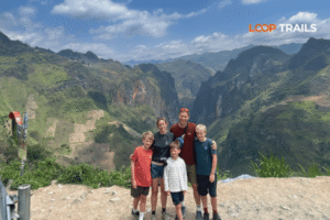
Children and elderly travelers. The Ha Giang Loop in a jeep is increasingly popular with families and older travelers, and the elevation is generally fine. Just plan for more breaks, more water, and less rushing.
Thinking about which tour format makes the most sense for your group? Loop Trails runs jeep tours designed specifically for families, couples, and small groups who want the full Ha Giang Loop experience with more comfort and safety built in. [Check the jeep tour options →]

Learn more: Ha Giang Cao Bang Ba Be Lake 6 Days 5 Nights
You do not need to train like an athlete to do the Ha Giang Loop. But a few simple habits in the days before your trip genuinely change how you feel on the road.
Hydrate more than you think you need to. Dehydration and mild altitude symptoms feel almost identical — headache, fatigue, difficulty concentrating. On the loop, you are often so caught up in the riding that you forget to drink water. Carry a minimum of two litres per riding day and actually finish it.
Sleep well before you start. A night bus from Hanoi means you arrive in Ha Giang already short on proper rest. If you can, arrive the night before and sleep in a real bed. Even one extra night of good sleep before the loop begins makes a noticeable difference in how your body handles the climb.
Ease into the riding pace. Day one of the loop is typically the gentlest in terms of elevation gain. Use that day to settle into the rhythm — do not try to prove anything. There is a reason guides build the itinerary the way they do.
Pack paracetamol (acetaminophen). This is the standard first response to a mild altitude headache. It works. Keep it accessible in your day bag, not buried in your luggage.
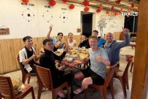
Eat properly. Homestay meals on the loop are genuinely good — local food, fresh ingredients, filling. Eat them. Skipping meals to keep pace with the itinerary leaves you running on empty at the worst possible time.
Avoid ibuprofen on heavy riding days. Some travelers take ibuprofen prophylactically for altitude — this is a practice with mixed evidence and some risks, particularly for your stomach. Paracetamol is safer and equally effective for symptom relief at these elevations. Always check with your own doctor.
Consider Diamox only if advised by a doctor. Acetazolamide (Diamox) is a prescription medication used to prevent altitude sickness. At Ha Giang’s elevations it is rarely necessary, but if your doctor recommends it based on your medical history, follow their guidance.

Learn more: Ha Giang Loop Mistake to Avoid
The single most important thing you can do if altitude symptoms start: tell your guide immediately.
This sounds obvious but many travelers try to push through it quietly, not wanting to slow the group down or seem like they cannot handle the route. Loop guides have dealt with this situation many times. They know the route, they know which stops offer good rest opportunities, and they can adjust the pace or the plan if needed.
Practical steps when symptoms appear:
The good news: in most cases, a proper rest stop, hydration, and a bit of food is all it takes. The loop itinerary has natural rest points built into every day. Use them.

Learn more: Ha Giang Loop by Jeep for Families & Groups
If altitude or physical exertion is a real concern — for health reasons, age, traveling with children, or personal preference — the jeep tour is genuinely worth considering. Not because the loop is dangerous on a motorbike, but because the jeep removes the physical demand of riding at elevation for five to seven hours a day.
On the jeep tour, you still stop at every major viewpoint. You still walk to Lung Khuy Cave, trek along the Ma Pi Leng Skywalk, and take the boat tour on the Nho Que River. You still stay in local homestays and share meals with the group. The experience is not diluted — the vehicle is just different.
For families with young children, couples where one person is less confident on motorbikes, or travelers managing a health condition, the jeep format often delivers a more relaxed and equally rewarding version of the loop.
Loop Trails runs jeep tours in small groups. The 3-day/2-night and 4-day/3-night Ha Giang Loop and the 5-day/4-night Ha Giang to Cao Bang route are all available in jeep format. [See jeep tour itineraries and pricing →]

Learn more: Ha Giang Motorbike Rental
If you are riding by motorbike — either as an easy rider passenger or self-driving — here are a few things that specifically relate to riding at altitude that most guides do not spell out clearly.
The cold hits harder than you expect. Wind chill at speed drops the perceived temperature significantly. At 1,000–1,500 metres, even on a sunny day, riding at 40–50 km/h can feel genuinely cold. Pack a proper base layer and a windproof jacket, not just a light hoodie.
Your bike performs slightly differently at elevation. Motorbike engines are less efficient at altitude — the air is thinner, combustion is slightly weaker. For self-drive riders, this means climbs feel harder than they would at sea level. Take them steady. There is no rush and the road is not going anywhere.
Eye protection matters. The plateau roads can be dusty, and wind at speed at high elevation is harsh on unprotected eyes. Goggles or good-quality sunglasses are not optional.
Breaks are not weakness. The Ha Giang Loop is famous for its views and its road, not for how fast you can complete it. Every stop on the itinerary is there because it is worth stopping for. Use the time to walk around, breathe properly, and let your body recover between riding stretches.
For self-drive riders: make sure your documentation is correct before you start. You need your passport, your home driving licence, and an International Driving Permit (IDP) — specifically IDP 1968 format. IDP 1949 is not valid in Vietnam. Riding without the correct documentation can result in fines of 2,000,000 to 6,000,000 VND. If you are on a guided easy rider tour, your guide handles local navigation and can assist with any traffic stops.

Learn more: Ha Giang Loop Weather
Altitude symptoms and cold symptoms overlap in ways that can confuse even experienced travelers. If you wake up at a Dong Van homestay at 5am feeling rough, here is a quick mental checklist.
Could it be cold? The plateau gets genuinely cold at night, particularly from October through March. Night temperatures can drop below 10°C, and homestay bedding is not always equal to that. If you are cold and your gear is inadequate, warmth and extra blankets solve the problem. This is not altitude — it is just cold.
Could it be the food or water? Stomach problems are more common in rural homestay settings than altitude sickness is. If the main symptom is digestive rather than a headache or breathing issue, treat it accordingly.
Could it be exhaustion? An eight-hour riding day through mountain roads, combined with a celebration dinner and some happy water the night before, explains a lot of morning-after suffering that has nothing to do with altitude.
Is it actually altitude? Persistent headache that paracetamol barely touches, unusual breathlessness at rest, confusion or loss of coordination — these are the signals to take seriously.
The best prevention for all of the above is the same: sleep enough, eat properly, drink water, and pace yourself. These are boring pieces of advice that genuinely work.

Learn more: Ha Giang Loop Easy Rider
Here is a straightforward breakdown based on who you are and what you want.
Ha Giang Loop 3 Days / 2 Nights — best for travelers with limited time who still want the core experience: Dong Van, Ma Pi Leng Pass, and Du Gia. Available as easy rider, self-drive, or jeep.
Ha Giang Loop 4 Days / 3 Nights — the most complete loop experience. Adds Lung Cu Flag Tower, Lo Lo Chai village, the boat tour on Nho Que River, and a full morning at Du Gia waterfall. Recommended for first-timers who want to do the loop properly.
Ha Giang to Cao Bang 5 Days / 4 Nights — for travelers who want to go beyond the loop and keep moving northeast. This route adds Bao Lac, Ban Gioc Waterfall, Nguom Ngao Cave, and ends in Cao Bang city. One of the most spectacular overland routes in northern Vietnam.
Motorbike options: Easy rider (you ride pillion with an experienced local guide driver) or self-drive (you drive your own rented bike, guide leads the way). Self-drive requires correct documentation.
Jeep option: Available for the loop and the Cao Bang extension. Private vehicle for your group, same itinerary, same homestays, more physical comfort. Especially suited to families, couples, and travelers with health considerations.
[View all Ha Giang Loop tours →] | [Ask via WhatsApp →]
Not sure which option fits your situation? Drop us a message on WhatsApp with your travel dates, group size, and any health or experience questions. We answer quickly and we will give you a straight recommendation, not a sales pitch.

Learn more: Ha Giang in September & October
The Ha Giang Loop changes significantly by season, and that interacts with altitude in important ways.
September to November is widely considered the best time. The rice terraces are golden, the weather is generally stable, the air is clear enough to see the limestone ridges for kilometres, and the temperatures are cool but manageable.
December to February is cold at elevation — genuinely cold, not just “bring a light jacket” cold. Some travelers love this period for the quiet roads and misty landscapes. Go prepared with proper winter layers, particularly for the plateau and the higher passes.
March to May brings warmer temperatures and the buckwheat flower season, which turns the plateau into something that looks like a film set. Roads can be dusty. It is increasingly popular and worth considering if you are flexible on timing.
June to August is rainy season. Roads can be slippery, mist reduces visibility on the passes, and some routes become challenging. Not impossible, but requiring more caution. Check conditions before you go and listen to your guide’s advice on road safety.
Altitude amplifies whatever the season is doing. A rainy day at 1,400 metres is significantly less pleasant than a rainy day at sea level. A cold night on the Dong Van plateau in January is properly cold. Factor the season into your packing and your expectations.
")
Learn more: Ha Giang Loop Hidden Gems
Mild symptoms: headache, fatigue, slightly disrupted sleep — affect some riders, particularly those who arrive in Ha Giang and start the loop the same day without any acclimatisation time. Serious altitude sickness requiring evacuation is very rare at these elevations for healthy adults.
Lung Cu Flag Tower sits at approximately 1,470 metres and is one of the highest points most riders reach. The area around Ma Pi Leng Pass also reaches 1,200–1,500 metres depending on the specific section of road.
Many travelers with mild asthma complete the loop without issues. Bring your inhaler, make sure your guide knows, and consider the jeep option if motorbike riding might aggravate your breathing. Consult your doctor before the trip.
The itinerary covers the same key stops — the passes, the viewpoints, the villages, the homestays. The jeep format removes the physical demand of riding and is better suited to families, older travelers, and those with health considerations. The landscapes are identical.
A windproof jacket, a thermal base layer, and gloves are essential for riding days, even in the warmer months. From October through March, add a proper mid-layer and warm socks. Homestays typically have blankets but quality varies.
Yes. You need your home driving licence plus an International Driving Permit (IDP) in the 1968 format. IDP 1949 is not valid in Vietnam. Riding without the correct documents can result in a fine of 2,000,000 to 6,000,000 VND. Rules can change — check local updates before your trip.
The jeep tour makes the loop very accessible for families. Children do well on the route, the stops are varied enough to hold attention, and there is plenty of outdoor activity. The altitude at these levels is generally fine for healthy children.
Tell your guide immediately. Rest, hydrate, take paracetamol for headache, and do not push on to a higher elevation until you feel better. Guides are experienced with this and can adjust the day’s plan if needed.
September to November is the most popular and generally the most comfortable window. The weather is stable, the scenery is at its most photogenic, and the roads are in better condition than during rainy season.
Yes. The 2-day/1-night loop covers the main highlights of day one and a condensed version of the Ma Pi Leng section on day two. It is a taster, not the full experience. If you have time, the 3-day or 4-day version is significantly more rewarding.
Happy water is local rice wine, shared at homestays as part of the cultural experience. Alcohol dehydrates you and can amplify mild altitude symptoms the next morning. Drinking in moderation and compensating with extra water before bed makes the difference between a rough morning and a good one.
For most healthy travelers, no. The elevations involved are manageable without medication. If you have a history of altitude sickness or a relevant medical condition, discuss Diamox with your doctor before the trip — but do not self-prescribe it based on general advice.
Contact information for Loop Trails
Website: Loop Trails Official Website
Email: looptrailshostel@gmail.com
Hotline & WhatSapp:
+84862379288
+84938988593
Social Media:
Facebook: Loop Trails Tours Ha Giang
Instagram: Loop Trails Tours Ha Giang
TikTok: Loop Trails
Office Address: 48 Nguyen Du, Ha Giang 1, Tuyen Quang
Address: 48 Nguyen Du, Ha Giang 1, Tuyen Quang
Facebook X Reddit Table of Contents Learn more: Ha Giang Loop Tours Most people picture the Ha Giang Loop as a motorbike

Facebook X Reddit Table of Contents Learn more: Ha Giang Loop Tours Riding the Ha Giang Loop during Tet is one of
Facebook X Reddit Table of Contents Learn more: Ha Giang Loop Tours Dong Van sits at the far northern tip of Vietnam,